
Ficheiro:DETAIL OF MASONRY ARCH APPROACH SPAN ON THE MANHATTAN SIDE - Washington Bridge, Spanning Harlem River at One-hundred-eighty-first, New York, New York County, NY HAER NY,31-NEYO,162-5.tif

Tamaño desta vista previa en JPG do ficheiro en formato TIF: 771 × 599 píxeles. Outras resolucións: 309 × 240 píxeles | 618 × 480 píxeles | 988 × 768 píxeles | 1.280 × 995 píxeles | 2.560 × 1.990 píxeles | 5.000 × 3.887 píxeles.
Ficheiro orixinal (5.000 × 3.887 píxeles; tamaño do ficheiro: 18,54 MB; tipo MIME: image/tiff)
| Este ficheiro procede de Wikimedia Commons. A continuación móstrase a información da súa páxina de descrición. Commons é un repositorio libre de ficheiros multimedia. Pode contribuír alí cargando as súas imaxes. |
Resumo
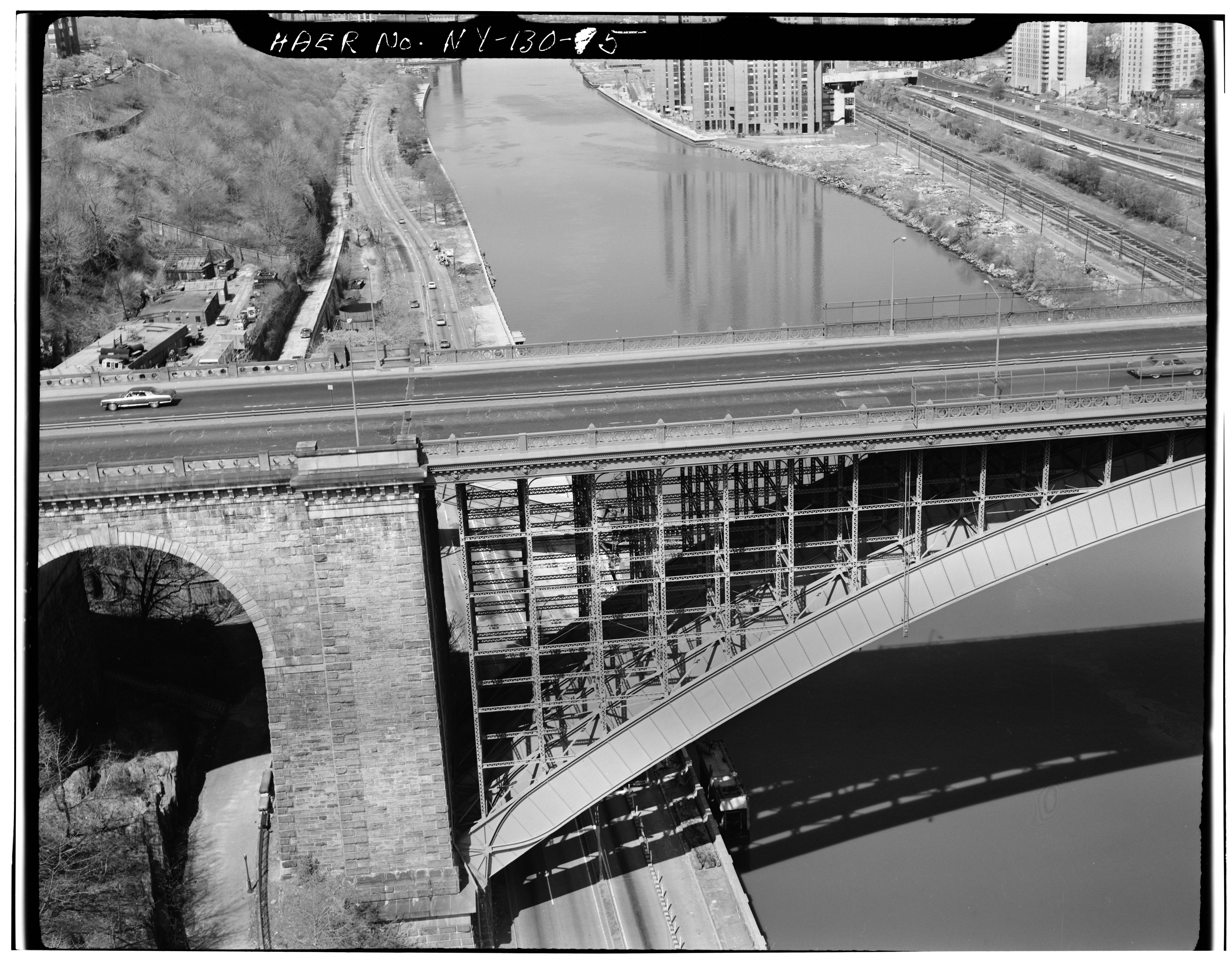
| DETAIL OF MASONRY ARCH APPROACH SPAN ON THE MANHATTAN SIDE - Washington Bridge, Spanning Harlem River at One-hundred-eighty-first, New York, New York County, NY | ||||
|---|---|---|---|---|
| Fotógrafo |
Related names:
|
|||
| Título |
DETAIL OF MASONRY ARCH APPROACH SPAN ON THE MANHATTAN SIDE - Washington Bridge, Spanning Harlem River at One-hundred-eighty-first, New York, New York County, NY |
|||
| Lugar representado | New York; New York County; New York | |||
| Data | Documentation compiled after 1968 | |||
| Dimensións | 4 x 5 in. | |||
| Localización |
Library of Congress Prints and Photographs Division Washington, D.C. 20540 USA http://hdl.loc.gov/loc.pnp/pp.print |
|||
| Número de acceso |
HAER NY,31-NEYO,162-5 |
|||
| Adquisición |
|
|||
| Notas |
|
|||
| Orixe | https://www.loc.gov/pictures/item/ny0979.photos.119115p | |||
| Licenza (Reuso deste ficheiro) |
|
|||

| Localización do obxectivo | | Esta e outras imaxes na súa localización en: OpenStreetMap |
|---|
Historial do ficheiro
Prema nunha data/hora para ver o ficheiro tal e como estaba nese momento.
| Data/Hora | Miniatura | Dimensións | Usuario | Comentario | |
|---|---|---|---|---|---|
| actual | 29 de xullo de 2014 ás 13:18 |  | 5.000 × 3.887 (18,54 MB) | Fæ | GWToolset: Creating mediafile for Fæ. HABS 24 July 2014 (2301:2600) |
Uso do ficheiro
A seguinte páxina usa este ficheiro:
Uso global do ficheiro
Os seguintes wikis empregan esta imaxe:
- Uso en ar.wikipedia.org
- Uso en bn.wikipedia.org
- Uso en en.wikipedia.org
- Uso en id.wikipedia.org