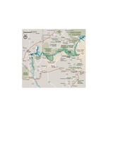
Ficheiro:NPS grand-canyon-regional-map.jpg

Tamaño desta vista previa: 649 × 600 píxeles. Outras resolucións: 260 × 240 píxeles | 520 × 480 píxeles | 831 × 768 píxeles | 1.196 × 1.105 píxeles.
Ficheiro orixinal (1.196 × 1.105 píxeles; tamaño do ficheiro: 207 kB; tipo MIME: image/jpeg)
Historial do ficheiro
Prema nunha data/hora para ver o ficheiro tal e como estaba nese momento.
| Data/Hora | Miniatura | Dimensións | Usuario | Comentario | |
|---|---|---|---|---|---|
| actual | 16 de maio de 2017 ás 23:15 |  | 1.196 × 1.105 (207 kB) | RKBot | =={{int:filedesc}}== {{Information |description= {{en|1=Need to zoom out? Here’s a map of roads near Grand Canyon, showing driving directions between the rims or to Las Vegas.}} |date= 2013-10-25 |source= U.S. National Park Service (http://npmaps.com... |
Uso do ficheiro
A seguinte páxina usa este ficheiro:
Uso global do ficheiro
Os seguintes wikis empregan esta imaxe:
- Uso en en.wikipedia.org
- Uso en is.wikipedia.org
- Uso en mr.wikipedia.org
- Uso en vi.wikipedia.org


