
Ficheiro:Huygens shoreline.jpg

Non se pode ver nunha resolución meirande.
Huygens_shoreline.jpg (305 × 261 píxeles; tamaño do ficheiro: 24 kB; tipo MIME: image/jpeg)
| Este ficheiro procede de Wikimedia Commons. A continuación móstrase a información da súa páxina de descrición. Commons é un repositorio libre de ficheiros multimedia. Pode contribuír alí cargando as súas imaxes. |
Resumo
| Descrición |
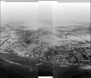
English: This composite was produced from images returned yesterday, January 14, 2005, by the European Space Agency's Huygens probe during its successful descent to land on Titan. It shows the boundary between the lighter-colored uplifted terrain, marked with what appear to be drainage channels, and darker lower areas. These images were taken from an altitude of about 8 kilometers (about 5 miles) and a resolution of about 20 meters (about 65 feet) per pixel. The images were taken by the Descent Imager/Spectral Radiometer, one of two NASA instruments on the probe.
Deutsch: Fotografie der Titanoberfläche während des Landeanflugs von Huygens. Man erkennt Hügel und topographische Merkmale, die einer Küstenregion mit Abflussgräben gleichen, 2005. |
| Data | |
| Orixe | http://photojournal.jpl.nasa.gov/catalog/PIA07231 (image link) |
| Autoría | NASA/JPL/ESA/University of Arizona |
Este ficheiro foi catalogado por Jet Propulsion Lab da Administración Nacional para a Aeronáutica e o Espazo (NASA) dos Estados Unidos de América baixo o identificador de fotografía: PIA07231.Esta etiqueta non indica o estado dos dereitos de autoría da obra adxunta. Segue sendo necesaria unha etiqueta sobre os dereitos de autoría. Pódese atopar máis información en Commons:Licenzas. Outras linguas:
|
Licenza
| Este ficheiro está no dominio público porque foi creado pola NASA. A política do copyright da NASA declara que "o material da NASA non está protexido polos dereitos de autor a non ser que se indique o contrario". (Páxina de políticas do copyright da NASA ou política de uso de imaxes JPL). | ||
 |
Avisos:
|
Rexistro de cargas orixinal
(All user names refer to en.wikipedia)
- 2005-01-15 18:17 The Singing Badger 305×261×8 (25004 bytes) Descent image of Titan taken during Huygens' landing, showing an apparent shoreline with hills and drainage channels {{PD-USGov-NASA}}
Historial do ficheiro
Prema nunha data/hora para ver o ficheiro tal e como estaba nese momento.
| Data/Hora | Miniatura | Dimensións | Usuario | Comentario | |
|---|---|---|---|---|---|
| actual | 14 de novembro de 2007 ás 17:31 | | 305 × 261 (24 kB) | File Upload Bot (Magnus Manske) | {{BotMoveToCommons|en.wikipedia}} {{Information |Description={{en|Image of Titan taken during Huygens' descent, showing hills and topographical features that resemble a shoreline and drainage channels Credit: [ |
Uso do ficheiro
A seguinte páxina usa este ficheiro:
Uso global do ficheiro
Os seguintes wikis empregan esta imaxe:
- Uso en als.wikipedia.org
- Uso en ar.wikipedia.org
- Uso en de.wikipedia.org
- Uso en en.wikipedia.org
- Uso en fr.wikipedia.org
- Uso en id.wikipedia.org
- Uso en io.wikipedia.org
- Uso en it.wikipedia.org
- Uso en ja.wikipedia.org
- Uso en lb.wikipedia.org
- Uso en nl.wikipedia.org
- Uso en no.wikipedia.org
- Uso en ru.wikipedia.org
- Uso en simple.wikipedia.org
- Uso en sr.wikipedia.org
- Uso en sv.wikipedia.org
- Uso en zh.wikipedia.org