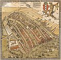
Ficheiro:De Groote Kaart van Amsterdam in 1544 (The Big Map of Amsterdam in 1544) by Cornelis Anthonisz.jpg

Os contidos da páxina non están dispoñibles noutras linguas.
Na Galipedia, a Wikipedia en galego.

Ficheiro orixinal(8.738 × 8.595 píxeles; tamaño do ficheiro: 20,92 MB; tipo MIME: image/jpeg)

Resumo

Artista
Cornelis Anthonisz.  (entre 1505
date QS:P,+1505–00–00T00:00:00Z/9,P1480,Q5727902
–1553)  wikidata:Q2761474
 
Cornelis Anthonisz.
Nomes alternativos
Cornelis Anthoniszoon, Cornelis Anthonisz. Teunissen, Cornelis Anthonisz. Teunisz., Cornelis Anthonisz. Theunissen, Cornelis Anthonisz. Thonisz.
Descrición pintor,

cartógrafo, gravador e

projetista neerlandés
Datas de nacemento e morte entre 1505
date QS:P,+1505-00-00T00:00:00Z/9,P1480,Q5727902
1553 Editar isso no Wikidata
Lugares de nacemento e morte Ámsterdam Ámsterdam
Lugar de traballo
Control de autoridade
artist QS:P170,Q2761474
Título
Nederlands: De Groote kaart van Amsterdam in 1544 van Kornelis Antoniszoon... behoorende bij het vijfde deel der geschiedenis van Amsterdam / door J. Ter Gouw, naar het oorspronkelijke gephotographeerd...
English: The Big Map of Amsterdam in 1544 by Kornelis Antoniszoon... belonging to the fifth part of the history of Amsterdam / by J. Ter Gouw, photographed after the original...
Descrición
Français : Sujet : Amsterdam. Couverture : Pays-Bas. Langue : néerlandais. Éditeur : T. Van Holkema (Amsterdam).
English: Subject: Amsterdam. Coverage: Netherlands. Language: Dutch. Publisher: T. Van Holkema (Amsterdam). This is the full map. Extra info: "A bird's eye view of Amsterdam looking south. This is the city before the construction of the semi-circular ring of canals. It is bordered by the IJ, the Singel in the west, and the Kloveniersburgwal/Gelderse Kade in the east. The waterway in the middle (connecting the Dam with the IJ) is known as the Damrak. Ships were unloaded on the west bank of the Damrak, indicated on the map as ‘Opt Waeter’ (on the water). Woodcut by Cornelis Anthonisz. dated 1544. This version is a reprint published around 1885."
Data 1885 (the original version is from 1544)
Dimensións altura: 30 cm; ancho: 36 cm
dimensions QS:P2048,30U174728
dimensions QS:P2049,36U174728
institution QS:P195,Q193563
Inscricións

Legenda no topo direito:

De vermaerde koopstadt / van Amstelredam, gheconterfeyt met alle / sijn Wateren, Bruggen, Straten, kercken, kloo- / steren, Huysen, Toorens, Poorten ende Mueren, / ende omleggende situatie, gemaekt ter eeren K. M. / ende oock den Eersamen Raedt der selver Stadt, / ende alle Liefhebberen der Konste, etc. // Wtgegeven by Cornelis Anthonizoon Schil- / der, met Octroye der K. M. onsen ghenadighsten Heere van 't selfde niet te / moghen nae-drucken noch verkoopen binnen den tijdt van ses Jaren lanck / gheduerende, ende ghedateert van den Jare duysent vijf-honderd drie-en- / veertigh, op seeckere penen int selvde Octroye begrepen, op dat hem een yege- / lijck voor schade verhoede mach. // Dese afbeeldinghe vindtmen te koop in die ver- / maerde koopstadt van Amstelredam achter de Nieuwe Kerck / by den voorsz Cornelis Anthoniszoon, Schilder / inde Schrijvende handt.
Referencias
Français : Notice du catalogue : http://catalogue.bnf.fr/ark:/12148/cb40719984d
Orixe/Fotógrafo
Français : Bibliothèque nationale de France, département Cartes et plans, GE DD-2763
Bibliothèque nationale de France
(25/28)
English: Bibliothèque nationale de France, Maps and plans department, GE DD-2763
Licenza
(Reuso deste ficheiro)
Previous public domain rationale, no longer applicable
Public domain
Esta imaxe da Biblioteca Nacional de Francia (BNF) é unha reprodución dixital dunha obra bidimensional que está arestora no dominio público ({{PD-scan}}). Por este motivo, considérase obra de dominio público. A imaxe pódese consultar tamén na Gallica: btv1b525134777 (id.)

العربية  Deutsch  English  español  français  galego  italiano  日本語  македонски  Nederlands  português  русский  sicilianu  slovenščina  українська  +/−

Licenza

Esta é unha reproducción fotográfica fiel dunha obra de arte bidimensional no dominio público. A obra de arte en si mesma atópase no dominio público polo seguinte motivo:
Public domain

Este material está no dominio público nos demais países onde os dereitos de autor se estenden por 100 anos (ou menos) trala morte do autor.


Este arquivo está no dominio público nos Estados Unidos xa que foi publicado antes do 1 de xaneiro de 1929.

A posición oficial da Fundación Wikimedia é que "as reproducións fieis de obras de arte bidimensionais no dominio público atópanse en si mesmas no dominio público".
Esta reprodución fotográfica considérase polo tanto no dominio público.
Noutras xurisdicións a reutilización deste contido pode estar rextrinxida; vexa Reutilización de fotografías PD-Art para máis información.

Pés de foto

Engada unha explicación dunha liña do representa este ficheiro

Elementos retratados neste ficheiro

representa a

Historial do ficheiro

Prema nunha data/hora para ver o ficheiro tal e como estaba nese momento.

Data/HoraMiniaturaDimensiónsUsuarioComentario
actual9 de abril de 2023 ás 02:46Miniatura da versión ás 02:46 do 9 de abril de 20238.738 × 8.595 (20,92 MB)ArtanisenImproved alignment of the sections, reduced grid lines (same source)
7 de abril de 2023 ás 19:34Miniatura da versión ás 19:34 do 7 de abril de 20238.857 × 8.787 (22,31 MB)ArtanisenImproved spacing of the artwork sections (same source)
7 de abril de 2023 ás 07:00Miniatura da versión ás 07:00 do 7 de abril de 20238.955 × 8.857 (22,76 MB)ArtanisenUploaded a work by Cornelis Anthonisz. (circa 1505-1553). Auteur du texte from Bibliothèque nationale de France, département Cartes et plans, GE DD-2763 Bibliothèque nationale de France (25/28) - http://gallica.bnf.fr/ark:/12148/btv1b525134777/ with UploadWizard

A seguinte páxina usa este ficheiro:

Uso global do ficheiro

Metadatos