
Ficheiro:Chongqing, China ESA23338300.jpeg

Ficheiro orixinal (2.126 × 2.126 píxeles; tamaño do ficheiro: 1,56 MB; tipo MIME: image/jpeg)
| Este ficheiro procede de Wikimedia Commons. A continuación móstrase a información da súa páxina de descrición. Commons é un repositorio libre de ficheiros multimedia. Pode contribuír alí cargando as súas imaxes. |
Resumo
| Descrición |
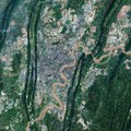
English: Chongqing, the largest municipality in China, is featured in this Copernicus Sentinel-2 image. Covering an area of over 80 000 sq km, around the size of Austria, Chongqing is located in southwest-central China. Chongqing covers a large area crisscrossed by rivers and mountains. These are the Daba Mountains in the north, the Wu Mountains in the east, the Wuling Mountains in the southeast and the Dalou Mountains in the south. The city of Chongqing, one of the most important economic centres in China, is known as a ‘mountain city’ owing to its rugged terrain and steep gorges. Chongqing is a major manufacturing and transportation centre, and has become the biggest automobile manufacturing base in China. The city lies at the confluence of the Yangtze and Jialing rivers, where the clashing colours of the rivers meet. The Yangtze river is visible in brown in the right of the image, while the green waters of the Jialing can be seen in the left. The rivers make Chongqing China's biggest port city in the southwest region. With a length of 6300 km, the Yangtze is the longest river in both China and Asia and the third longest river in the world. The Jialing River, rises in the Qin Mountains, and joins the Yangtze after a course of around 1190 km. Copernicus Sentinel-2 is a two-satellite mission. Each satellite carries a high-resolution camera that images Earth’s surface in 13 spectral bands. The mission is mostly used to track changes in the way land is being used and to monitor the health of our vegetation. This image is also featured on the Earth from Space video programme. |
| Data | 11 de xuño de 2021 (data do carregamento) |
| Orixe | Chongqing, China |
| Autoría | European Space Agency |
| Outras versións |
|
| Activity | Observing the Earth |
| Mission | Sentinel-2 |
| Set | Earth observation image of the week |
| System | Copernicus |
Licenza

|
This image contains data from a satellite in the Copernicus Programme, such as Sentinel-1, Sentinel-2 or Sentinel-3. Attribution is required when using this image.
Recoñecemento: Contains modified Copernicus Sentinel data 2018
The use of Copernicus Sentinel Data is regulated under EU law (Commission Delegated Regulation (EU) No 1159/2013 and Regulation (EU) No 377/2014). Relevant excerpts:
Free access shall be given to GMES dedicated data [...] made available through GMES dissemination platforms [...].
Access to GMES dedicated data [...] shall be given for the purpose of the following use in so far as it is lawful:
GMES dedicated data [...] may be used worldwide without limitations in time.
GMES dedicated data and GMES service information are provided to users without any express or implied warranty, including as regards quality and suitability for any purpose. |
This media was created by the European Space Agency (ESA).
Where expressly so stated, images or videos are covered by the Creative Commons Attribution-ShareAlike 3.0 IGO (CC BY-SA 3.0 IGO) licence, ESA being an Intergovernmental Organisation (IGO), as defined by the CC BY-SA 3.0 IGO licence. The user is allowed under the terms and conditions of the CC BY-SA 3.0 IGO license to Reproduce, Distribute and Publicly Perform the ESA images and videos released under CC BY-SA 3.0 IGO licence and the Adaptations thereof, without further explicit permission being necessary, for as long as the user complies with the conditions and restrictions set forth in the CC BY-SA 3.0 IGO licence, these including that:
See the ESA Creative Commons copyright notice for complete information, and this article for additional details.
|
 | |
Este ficheiro está licenciado baixo a licenza Creative Commons recoñecemento compartir igual 3.0 IGO. Recoñecemento: ESA, CC BY-SA IGO 3.0
| ||
Historial do ficheiro
Prema nunha data/hora para ver o ficheiro tal e como estaba nese momento.
| Data/Hora | Miniatura | Dimensións | Usuario | Comentario | |
|---|---|---|---|---|---|
| actual | 11 de xuño de 2021 ás 10:28 | | 2.126 × 2.126 (1,56 MB) | OptimusPrimeBot | #Spacemedia - Upload of https://www.esa.int/var/esa/storage/images/esa_multimedia/images/2021/06/chongqing_china/23338289-1-eng-GB/Chongqing_China.jpg via Commons:Spacemedia |
Uso do ficheiro
A seguinte páxina usa este ficheiro:
Uso global do ficheiro
Os seguintes wikis empregan esta imaxe:
- Uso en arz.wikipedia.org
- Uso en ast.wikipedia.org
- Uso en ba.wikipedia.org
- Uso en ca.wikipedia.org
- Uso en ce.wikipedia.org
- Uso en cy.wikipedia.org
- Uso en de.wikivoyage.org
- Uso en el.wikipedia.org
- Uso en en.wikivoyage.org
- Uso en eo.wikinews.org
- Uso en fr.wikivoyage.org
- Uso en ga.wikipedia.org
- Uso en ha.wikipedia.org
- Uso en he.wikivoyage.org
- Uso en hy.wikipedia.org
- Uso en ia.wikipedia.org
- Uso en incubator.wikimedia.org
- Uso en it.wikivoyage.org
- Uso en mhr.wikipedia.org
- Uso en no.wikipedia.org
- Uso en qu.wikipedia.org
- Uso en ru.wikinews.org
- Uso en sr.wikipedia.org
- Uso en tt.wikipedia.org
- Uso en vec.wikipedia.org
- Uso en www.wikidata.org