
Ficheiro:Types of offshore oil and gas structures.jpg
Non se pode ver nunha resolución meirande.
Types_of_offshore_oil_and_gas_structures.jpg (600 × 236 píxeles; tamaño do ficheiro: 97 kB; tipo MIME: image/jpeg)
| Este ficheiro procede de Wikimedia Commons. A continuación móstrase a información da súa páxina de descrición. Commons é un repositorio libre de ficheiros multimedia. Pode contribuír alí cargando as súas imaxes. |
Resumo
| Descrición |
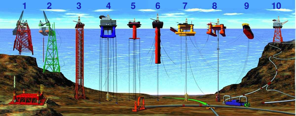
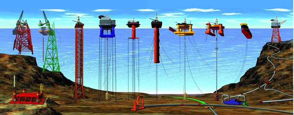
English: Types of Offshore Oil and Gas Structures
Deutsch: Arten von Öl- und Gasbohrinseln
|
| Data | Revised at 15 de decembro de 2008 |
| Orixe | |
| Autoría |
|
| Outras versións |
|

Licenza
Esta imagem está em domínio público pois ela contém material que vieram originalmente da National Oceanic and Atmospheric Administration dos EUA, tirada ou feita durante o trajeto de um funcionário em obrigações oficiais.
|
Historial do ficheiro
Prema nunha data/hora para ver o ficheiro tal e como estaba nese momento.
| Data/Hora | Miniatura | Dimensións | Usuario | Comentario | |
|---|---|---|---|---|---|
| actual | 25 de outubro de 2013 ás 19:44 | 600 × 236 (97 kB) | Jaybear | Numbers added; | |
| 23 de maio de 2010 ás 17:56 | 600 × 236 (72 kB) | Emerson7 | {{Information |Description = Types of offshore oil and gas structures incude: 1, 2) conventional fixed platforms (deepest: Shell’s Bullwinkle in 1991 at 412 m/1,353 ft GOM); 3) compliant tower (deepest: ChevronTexaco’s Petronius in 1998 at 534 m / |
Uso do ficheiro
A seguinte páxina usa este ficheiro:
Uso global do ficheiro
Os seguintes wikis empregan esta imaxe:
- Uso en ar.wikipedia.org
- Uso en cs.wikipedia.org
- Uso en de.wikipedia.org
- Uso en en.wikipedia.org
- Uso en eo.wikipedia.org
- Uso en es.wikipedia.org
- Uso en fr.wikipedia.org
- Uso en fy.wikipedia.org
- Uso en ha.wikipedia.org
- Uso en he.wikipedia.org
- Uso en it.wikipedia.org
- Uso en ja.wikipedia.org
- Uso en nl.wikipedia.org
- Uso en pl.wikipedia.org
- Uso en pt.wikipedia.org
- Uso en ru.wikipedia.org
- Uso en sh.wikipedia.org
- Uso en sk.wikipedia.org
- Uso en sl.wikipedia.org
- Uso en tr.wikipedia.org
- Uso en uk.wikipedia.org
- Uso en vi.wikipedia.org
- Uso en zh-yue.wikipedia.org
- Uso en zh.wikipedia.org