
Ficheiro:The Portuguese Empire.png

Tamaño desta vista previa: 800 × 407 píxeles. Outras resolucións: 320 × 163 píxeles | 640 × 325 píxeles | 1.024 × 521 píxeles | 1.280 × 651 píxeles | 2.753 × 1.400 píxeles.
Ficheiro orixinal (2.753 × 1.400 píxeles; tamaño do ficheiro: 232 kB; tipo MIME: image/png)
| Este ficheiro procede de Wikimedia Commons. A continuación móstrase a información da súa páxina de descrición. Commons é un repositorio libre de ficheiros multimedia. Pode contribuír alí cargando as súas imaxes. |

|
Esta imaxe (ou todas as imaxes deste artigo ou categoría) deberían volverse crear como imaxes vectoriais SVG. Isto proporciona moitas vantaxes, véxase Commons:Media for cleanup (en inglés) para máis información. Se xa hai unha versión SVG desta imaxe dispoñible, por favor, cárguea en Commons. Tras subila, substitúa este modelo polo modelo {{vector version available|novo nome da imaxe.svg}} nesta imaxe.
|
Resumo
| Descrición |
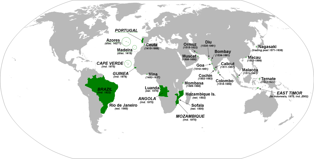
English: The principal forts, trading posts and colonies of the Portuguese Empire (1415-1999).
Abbreviations: disc: date of discovery est: date of establishment ind: date of independence Present-day Portuguese territory is underlined in green. |
| Data | |
| Orixe | Obra propia |
| Autoría | The Red Hat of Pat Ferrick |
Licenza
| Eu, como posuidor dos dereitos de autor desta obra, libéroa para que pertenza ao dominio público. Isto é válido en todo o mundo. Nalgúns países, isto pode non ser legalmente posible; entón: Concedo a calquera o dereito de empregar esta obra para o propósito que considere oportuno, sen condicións, agás aquelas que sexan requiridas pola lei. |
Historial do ficheiro
Prema nunha data/hora para ver o ficheiro tal e como estaba nese momento.
| Data/Hora | Miniatura | Dimensións | Usuario | Comentario | |
|---|---|---|---|---|---|
| actual | 3 de febreiro de 2018 ás 01:46 | | 2.753 × 1.400 (232 kB) | 42800141 | Removed the state of Acre from the rest of Brazil and the border between Brazil and Uruguay |
| 8 de xaneiro de 2009 ás 02:02 |  | 2.753 × 1.400 (214 kB) | The Red Hat of Pat Ferrick | lose a few arrows | |
| 5 de xaneiro de 2009 ás 02:16 |  | 2.753 × 1.400 (223 kB) | The Red Hat of Pat Ferrick | forgot E. Timor | |
| 5 de xaneiro de 2009 ás 01:09 |  | 2.753 × 1.400 (214 kB) | The Red Hat of Pat Ferrick | Underlines for present day Portuguese territory | |
| 5 de xaneiro de 2009 ás 00:49 |  | 2.753 × 1.400 (214 kB) | The Red Hat of Pat Ferrick | Arrow for Ceuta | |
| 5 de xaneiro de 2009 ás 00:46 |  | 2.753 × 1.400 (213 kB) | The Red Hat of Pat Ferrick | {{Information |Description={{en|1=The principle forts, trading posts and colonies of the Portuguese Empire (1415-1999). Abbreviations: est: date of establishment ind: date of independence }} |Source=Own work |Author=[[User:The Red Hat of Pat Ferrick|The |
Uso do ficheiro
As seguintes 2 páxinas usan este ficheiro:
Uso global do ficheiro
Os seguintes wikis empregan esta imaxe:
- Uso en ar.wikipedia.org
- Uso en ca.wikipedia.org
- Uso en de.wikipedia.org
- Uso en el.wikipedia.org
- Uso en en.wikipedia.org
- Uso en en.wikibooks.org
- Uso en et.wikipedia.org
- Uso en fa.wikipedia.org
- Uso en id.wikipedia.org
- Uso en incubator.wikimedia.org
- Uso en it.wikipedia.org
- Uso en pl.wikipedia.org
- Uso en pt.wikibooks.org
- Uso en qu.wikipedia.org
- Uso en sc.wikipedia.org
- Uso en uk.wikipedia.org
- Uso en zh.wikibooks.org