
Ficheiro:Sweden's Siljan Ring.jpeg

Ficheiro orixinal (3.808 × 4.003 píxeles; tamaño do ficheiro: 4,65 MB; tipo MIME: image/jpeg)
| Este ficheiro procede de Wikimedia Commons. A continuación móstrase a información da súa páxina de descrición. Commons é un repositorio libre de ficheiros multimedia. Pode contribuír alí cargando as súas imaxes. |
Resumo
| Descrición |
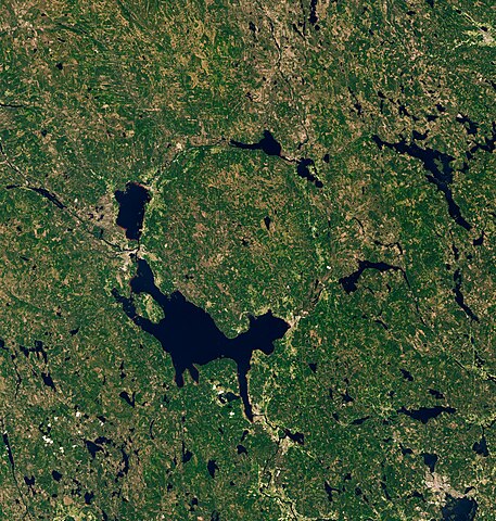
Covered with lakes, forests, and mountains, Dalarna County has been called “Sweden in miniature.” But the same region that today draws people to its idyllic lakeside villages and midsummer celebrations was also the site of an ancient, catastrophic impact. Around 380 million years ago, in the Late Devonian period, an asteroid slammed into the land that is now south-central Sweden. The impact left quite a mark. Even after hundreds of millions of years of erosion, the scar is still recognizable. It is especially apparent when viewed from above. The Siljan impact structure, or “Siljan Ring,” is visible in this image, acquired on June 24, 2020, with the Operational Land Imager (OLI) on Landsat 8. Measuring more than 50 kilometers (30 miles) across, Siljan is the largest-known impact structure in Europe and among the top-20 largest on Earth. Surveys of the structure have shown that the ground is slightly raised up across parts of the crater’s center. It is surrounded by a ring-like graben, or depression, which today is partially filled with water. Lake Siljan, on the crater’s southwest side, is the largest lake; it connects to Lake Orsa via a small river. People have lived for millennia near the crater without knowing its cosmic origin. In the late 1960s, scientists used drill cores to uncover the complex and ancient geology deep below the ground. Research at Siljan is ongoing today. In a 2019 study, scientists described how they used drill cores to find that the deep, fractured rocks in the crater were suitable for ancient life. A subsequent paper in 2021 described the fossilized remains of fungi discovered at a depth of more than 500 meters. |
| Data | 24 June 2020 |
| Orixe | https://earthobservatory.nasa.gov/images/148577/swedens-siljan-ring |
| Autoría | NASA Earth Observatory images by Lauren Dauphin, using Landsat data from the U.S. Geological Survey. Story by Kathryn Hansen. |
Licenza
| Este ficheiro está no dominio público porque foi creado pola NASA. A política do copyright da NASA declara que "o material da NASA non está protexido polos dereitos de autor a non ser que se indique o contrario". (Páxina de políticas do copyright da NASA ou política de uso de imaxes JPL). | ||
 |
Avisos:
|
Historial do ficheiro
Prema nunha data/hora para ver o ficheiro tal e como estaba nese momento.
| Data/Hora | Miniatura | Dimensións | Usuario | Comentario | |
|---|---|---|---|---|---|
| actual | 16 de novembro de 2022 ás 04:24 | | 3.808 × 4.003 (4,65 MB) | StellarHalo | {{Information |Description=Covered with lakes, forests, and mountains, Dalarna County has been called “Sweden in miniature.” But the same region that today draws people to its idyllic lakeside villages and midsummer celebrations was also the site of an ancient, catastrophic impact. Around 380 million years ago, in the Late Devonian period, an asteroid slammed into the land that is now south-central Sweden. The impact left quite a mark. Even after hundreds of millions of years of erosion, the... |
Uso do ficheiro
A seguinte páxina usa este ficheiro:
Uso global do ficheiro
Os seguintes wikis empregan esta imaxe:
- Uso en en.wikipedia.org
- Uso en fr.wikipedia.org