
Ficheiro:South Island.jpg

Ficheiro orixinal (2.618 × 2.926 píxeles; tamaño do ficheiro: 1,26 MB; tipo MIME: image/jpeg)
| Este ficheiro procede de Wikimedia Commons. A continuación móstrase a información da súa páxina de descrición. Commons é un repositorio libre de ficheiros multimedia. Pode contribuír alí cargando as súas imaxes. |
Resumo
| Descrición |
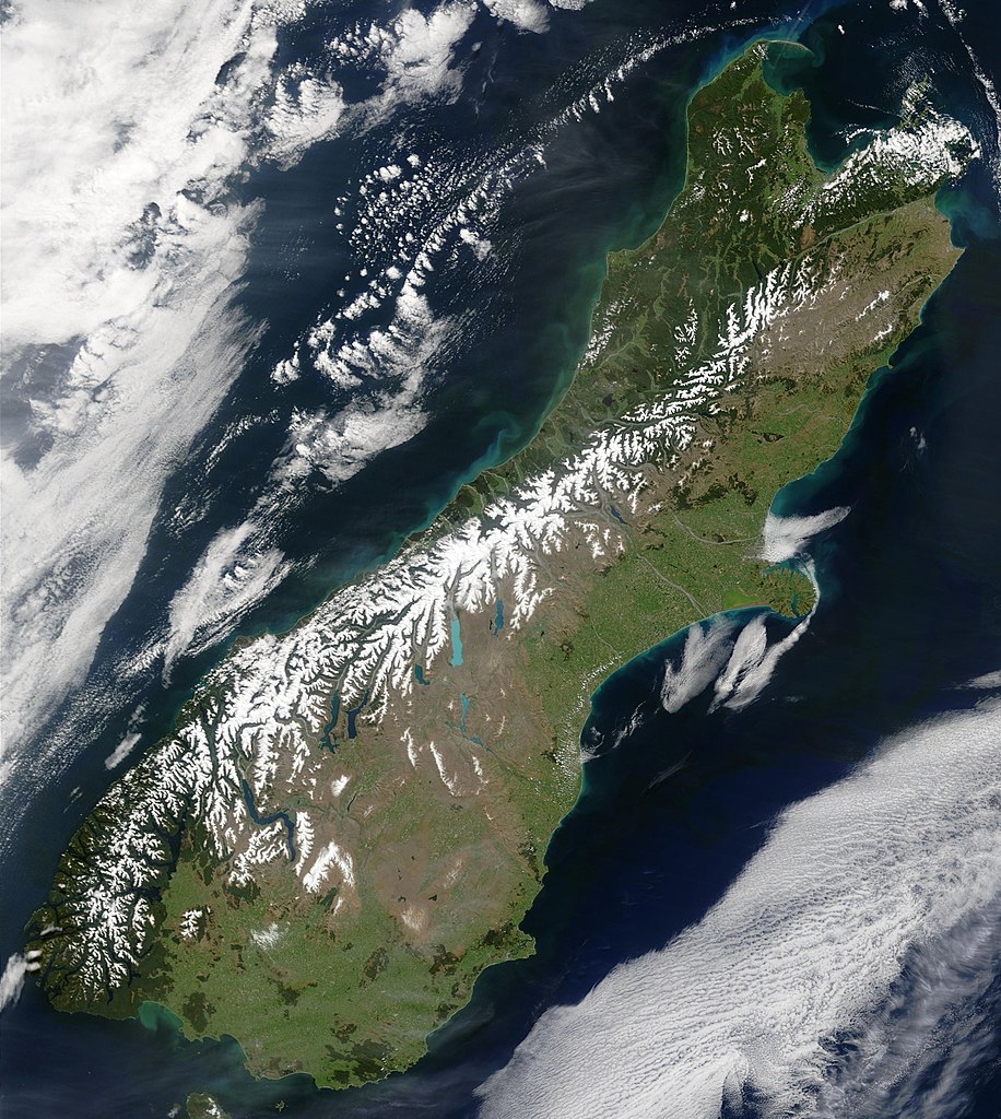
English: This true-color image provides a nearly cloud-free look at the South Island of New Zealand, from NASA’s Terra satellite.
Українська: Сніг виділяє гірські хребти Південних Альп (супутниковий знімок НАСА), Нова Зеландія. |
| Data | |
| Orixe | NASA's Earth Observatory |
| Autoría | Jacques Descloitres, MODIS Land Rapid Response Team at NASA GSFC |
| Licenza (Reuso deste ficheiro) |
Public domain - original work of NASA |
| Outras versións | Image:South.island.arp.750pix.jpg is lower resolution, more tightly cropped |
This true-color image provides a nearly cloud-free look at the South Island of New Zealand. The scene was acquired by NASA’s Terra satellite, on October 23, 2002.
Forested areas are clearly indicated by the very dark green, particularly in the northwest and southwest. The braided Waimakariri and Rakaia rivers can also clearly be seen as they make their way to the east coast on either side of Banks Peninsula.
Image courtesy Jacques Descloitres, MODIS Land Rapid Response Team at NASA GSFC.
SOURCE: http://earthobservatory.nasa.gov/Newsroom/NewImages/images.php3?img_id=10881
”The purpose of NASA's Earth Observatory is to provide a freely-accessible publication on the Internet where the public can obtain new satellite imagery and scientific information about our home planet. The focus is on Earth's climate and environmental change. In particular, we hope our site is useful to public media and educators. Any and all materials published on the Earth Observatory are freely available for re-publication or re-use, except where copyright is indicated. We ask that NASA's Earth Observatory be given credit for its original materials.”
Licenza
| Este ficheiro está no dominio público porque foi creado pola NASA. A política do copyright da NASA declara que "o material da NASA non está protexido polos dereitos de autor a non ser que se indique o contrario". (Páxina de políticas do copyright da NASA ou política de uso de imaxes JPL). | ||
 |
Avisos:
|
Historial do ficheiro
Prema nunha data/hora para ver o ficheiro tal e como estaba nese momento.
| Data/Hora | Miniatura | Dimensións | Usuario | Comentario | |
|---|---|---|---|---|---|
| actual | 18 de maio de 2006 ás 00:48 | | 2.618 × 2.926 (1,26 MB) | Avenue | {{Information| |Description=This true-color image provides a nearly cloud-free look at the South Island of New Zealand, from NASA’s Terra satellite. |Source=[http://earthobservatory.nasa.gov/Newsroom/NewImages/images.php3?img_id=10881 NASA's Earth Obser |
Uso do ficheiro
A seguinte páxina usa este ficheiro:
Uso global do ficheiro
Os seguintes wikis empregan esta imaxe:
- Uso en af.wikipedia.org
- Uso en ang.wikipedia.org
- Uso en an.wikipedia.org
- Uso en ar.wikipedia.org
- Uso en bh.wikipedia.org
- Uso en ceb.wikipedia.org
- Uso en cs.wikipedia.org
- Uso en da.wikipedia.org
- Uso en de.wikipedia.org
- Uso en de.wikivoyage.org
- Uso en el.wikipedia.org
- Uso en en.wikipedia.org
- Uso en en.wikiversity.org
- Uso en eo.wikipedia.org
- Uso en et.wikipedia.org
- Uso en fa.wikipedia.org
- Uso en fi.wikipedia.org
- Uso en fr.wikipedia.org
- Uso en he.wikipedia.org
- Uso en hi.wikipedia.org
- Uso en hr.wikipedia.org
- Uso en hu.wikipedia.org
- Uso en is.wikipedia.org
- Uso en it.wikipedia.org
- Uso en ja.wikipedia.org
- Uso en mi.wikipedia.org
- Uso en mk.wikipedia.org
- Uso en ml.wikipedia.org
- Uso en mn.wikipedia.org
- Uso en nl.wikipedia.org
- Uso en nn.wikipedia.org
- Uso en no.wikipedia.org
- Uso en oc.wikipedia.org
- Uso en pnb.wikipedia.org
- Uso en pt.wikipedia.org
- Uso en sh.wikipedia.org
- Uso en sk.wikipedia.org
- Uso en sl.wikipedia.org
- Uso en sr.wikipedia.org
- Uso en sv.wikipedia.org
- Uso en tpi.wikipedia.org
- Uso en tr.wikipedia.org
- Uso en zh-min-nan.wikipedia.org
Ollar o uso global deste ficheiro.