
Ficheiro:Dampier Mosquito.gif
Dampier_Mosquito.gif (500 × 375 píxeles; tamaño do ficheiro: 14 kB; tipo MIME: image/gif)
| Este ficheiro procede de Wikimedia Commons. A continuación móstrase a información da súa páxina de descrición. Commons é un repositorio libre de ficheiros multimedia. Pode contribuír alí cargando as súas imaxes. |
| Descrición |
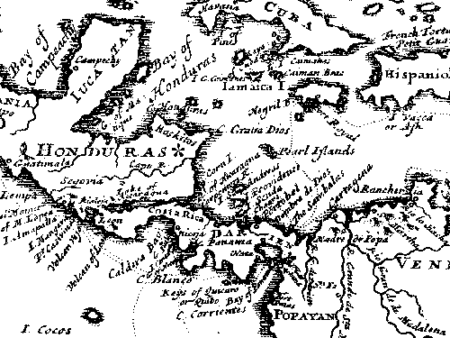
English: This map is from "A New Voyage Round the World", published in 1697 by William Dampier, the English sea captain, naturalist, and occasional pirate.
The Miskito coast is marked with a star. Dampier and his associate, the surgeon Lionel Wafer describe the Miskito peoples in the period 1690-1700. These tribal groups, often mixed with runaway slaves, formed a distinct culture in the coastal region, sometimes forming alliances with pirates against Spanish authorities in the 16th-18th centuries. |
| Orixe | |
| Autoría |
Licenza
|
Este material está no dominio público nos demais países onde os dereitos de autor se estenden por 70 anos (ou menos) trala morte do autor.
| |
| Este ficheiro foi identificado como libre de restricións baixo as leis de dereitos de autor, incluídos todos os dereitos relacionados. | |
Rexistro de cargas orixinal
All following user names refer to en.wikipedia.
- 2007-06-29 02:41 Victor falk 500×375× (13914 bytes) This map is from "A New Voyage Round the World", published in 1697 by William Dampier, the English sea captain, naturalist, and occasional pirate. The Miskito coast is marked with a star. Dampier and his associate, the surgeon Lionel Wafer describe the
Historial do ficheiro
Prema nunha data/hora para ver o ficheiro tal e como estaba nese momento.
| Data/Hora | Miniatura | Dimensións | Usuario | Comentario | |
|---|---|---|---|---|---|
| actual | 16 de outubro de 2009 ás 09:42 | | 500 × 375 (14 kB) | Urdangaray | {{Information |Description={{en|This map is from "A New Voyage Round the World", published in 1697 by William Dampier, the English sea captain, naturalist, and occasional pirate. The Miskito coast is marked with a star. Dampier and his associate, the su |
Uso do ficheiro
A seguinte páxina usa este ficheiro:
Uso global do ficheiro
Os seguintes wikis empregan esta imaxe:
- Uso en az.wikipedia.org
- Uso en en.wikipedia.org
- Uso en es.wikipedia.org
- Uso en he.wikipedia.org
- Uso en id.wikipedia.org
- Uso en tr.wikipedia.org
- Uso en uk.wikipedia.org
- Uso en zh.wikipedia.org