Ficheiro:Knowledge of English EU map.svg

Os contidos da páxina non están dispoñibles noutras linguas.
Na Galipedia, a Wikipedia en galego.

Ficheiro orixinal(ficheiro SVG; resolución de 590 × 603 píxeles; tamaño do ficheiro: 671 kB)

This image is an information graphic created by a computer program from data sets or formulas that have not been fully provided on this page. In order to allow other editors to improve or build such images, and to ensure compliance with free content licenses such as the GFDL, the following should be provided:
  • Software package(s) used
  • Data sets used (if any), including pre-processing instructions
  • Sequence of commands used to create the graphic
  • Short description of any post-processing stages
Once all the above are included in the image's description page(s), please remove this template.

Deutsch  English  français  magyar  Nederlands  Plattdüütsch  suomi  македонски  русский  日本語  中文  中文(简体)‎  +/−

Resumo

Descrición
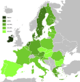
English: Map, in English of the knowledge of English language in EU.
Deutsch: Karte, die auf Englisch Kenntnisse der englischen Sprache in der EU zeigt.
Français : Carte des connaissances de l'anglais, en anglais, dans l'Union européenne.
Data (UTC)
Orixe
Autoría
Outras versións


Esta é unha imaxe retocada,en o que significa que a súa versión orixinal foi alterada dixitalmente. Modificacións: Hybridised to make vector version of English map. A orixinal pódese ver aquí: Knowledge English EU map.png. As modificacións realizounas Alphathon.

w:gl:Creative Commons
recoñecemento compartir igual
Este ficheiro está licenciado baixo a licenza Creative Commons recoñecemento compartir igual 3.0 sen adaptar.
Vostede é libre de:
  • compartir – copiar, distribuír e difundir a obra
  • facer obras derivadas – adaptar a obra
Baixo as seguintes condicións:
  • recoñecemento – Debe indicar a debida atribución de autoría, fornecer unha ligazón á licenza e indicar se se realizaron cambios. Pode facer isto de calquera forma razoable, mais non nunha forma que indique que quen posúe a licenza apoia ou subscribe o seu uso da obra.
  • compartir igual – Se altera, transforma ou amplía este contido, debe publicar as súas contribucións baixo a mesma licenza ou outra compatible á orixinal.

Rexistro de cargas orixinal

This image is a derivative work of the following images:

  • File:Knowledge_of_German_EU_map.png licensed with PD-self
    • 2009-05-23T22:36:14Z HernauMan 1218x1245 (56214 Bytes) {{Information |Description={{en|1=Knowledge of German language in EU with Croatia, Bosnia and Herzegovina, Switzerland and Turkey. }} |Source=Own work by uploader |Author=[[User:HernauMan|HernauMan]] |Date=2009-05-15 |Permiss
  • File:Knowledge_English_EU_map.png licensed with PD-self
    • 2010-08-13T09:57:14Z RoseAphro 1218x1245 (78412 Bytes) Reverted to version as of 11:13, 2 January 2009 See Discussion
    • 2009-11-10T09:34:49Z Scooter20 1218x1245 (85789 Bytes) Reverted to version as of 10:56, 13 March 2009
    • 2009-07-07T03:55:09Z Kombie2 1218x1245 (61153 Bytes) Corrected wrong text colour in the "NA" in the legend; in an informational map, text colours should be consistent to maximize readability. Also, customarily, a forward slash is entered between the letter 'N' and the letter
    • 2009-03-13T10:56:15Z MacedonianBoy 1218x1245 (85789 Bytes) Since Croatia and Turkey are not part of the EU and they shown, and Macedonia should be since it is candidate
    • 2009-01-02T11:13:54Z The Duke of Waltham 1218x1245 (78412 Bytes) Reverted to version as of 23:47, 15 February 2008 (FYROM is not in the EU)
    • 2008-12-11T12:35:26Z MacedonianBoy 1218x1245 (85789 Bytes)
    • 2008-02-15T23:47:46Z RedCoat 1218x1245 (78412 Bytes) Add Gibraltar.
    • 2006-12-19T09:56:40Z Hoshie 1218x1245 (85776 Bytes) Added Montenegro. Under same license as orginal
    • 2006-11-12T13:50:19Z Aaker 1218x1245 (85716 Bytes) Knowledge of English in the European Union, according to: "Special Eurobarometer 243" of the European Commission with the title "Europeans and their Languages" Made by myself

Carregada com derivativeFX

Pés de foto

Engada unha explicación dunha liña do representa este ficheiro

Elementos retratados neste ficheiro

representa a

Historial do ficheiro

Prema nunha data/hora para ver o ficheiro tal e como estaba nese momento.

Data/HoraMiniaturaDimensiónsUsuarioComentario
actual3 de febreiro de 2020 ás 10:36Miniatura da versión ás 10:36 do 3 de febreiro de 2020590 × 603 (671 kB)DarrancUpdate since UK left the EU
15 de febreiro de 2015 ás 23:30Miniatura da versión ás 23:30 do 15 de febreiro de 2015590 × 603 (671 kB)LeftcryUpdate layout and information
17 de outubro de 2011 ás 11:49Miniatura da versión ás 11:49 do 17 de outubro de 20111.212 × 1.242 (552 kB)Treehilldeletion of Turkey, I let only candidate country with an accession date planned (Croatia and Iceland).
7 de setembro de 2011 ás 06:34Miniatura da versión ás 06:34 do 7 de setembro de 20111.212 × 1.242 (552 kB)Treehill(norway was not deleted before, maybe an error)
6 de setembro de 2011 ás 20:58Miniatura da versión ás 20:58 do 6 de setembro de 20111.212 × 1.242 (552 kB)Treehilldeletion of Norway, as explained previously. Not an EU country (note that the name of the file is "Knowledge_of_English_EU_map.svg").
6 de setembro de 2011 ás 19:50Miniatura da versión ás 19:50 do 6 de setembro de 20111.212 × 1.242 (552 kB)TreehillI deleted Switzerland which is neither in the EU nor a candidate country.
12 de xullo de 2011 ás 11:12Miniatura da versión ás 11:12 do 12 de xullo de 20111.212 × 1.242 (552 kB)J intelaAdded Norway and Switzerland http://en.wikipedia.org/wiki/List_of_countries_by_English-speaking_population
8 de abril de 2011 ás 19:08Miniatura da versión ás 19:08 do 8 de abril de 20111.212 × 1.242 (552 kB)AlphathonImproved British Isles
27 de agosto de 2010 ás 17:42Miniatura da versión ás 17:42 do 27 de agosto de 20101.212 × 1.242 (520 kB)Alphathon{{Information |Description={{en|1=Knowledge of English language in EU}} |Source=*File:Knowledge_of_German_EU_map.png *File:Knowledge_English_EU_map.png |Date=2010-08-27 17:41 (UTC) |Author=*File:Knowledge_of_German_EU_map.png: [[User:Her

Non hai páxinas que usen este ficheiro.

Uso global do ficheiro

Os seguintes wikis empregan esta imaxe:

Ollar o uso global deste ficheiro.

Metadatos