
Ficheiro:Tabula hungariae.jpg

Tamaño desta vista previa: 421 × 600 píxeles. Outras resolucións: 168 × 240 píxeles | 337 × 480 píxeles | 539 × 768 píxeles | 719 × 1.024 píxeles | 1.438 × 2.048 píxeles | 3.236 × 4.609 píxeles.
Ficheiro orixinal (3.236 × 4.609 píxeles; tamaño do ficheiro: 3,27 MB; tipo MIME: image/jpeg)
| Este ficheiro procede de Wikimedia Commons. A continuación móstrase a información da súa páxina de descrición. Commons é un repositorio libre de ficheiros multimedia. Pode contribuír alí cargando as súas imaxes. |
Resumo
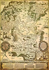
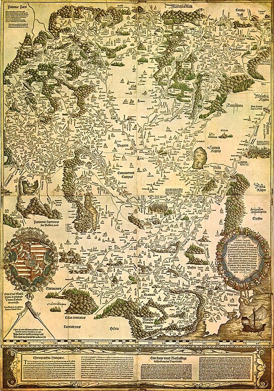
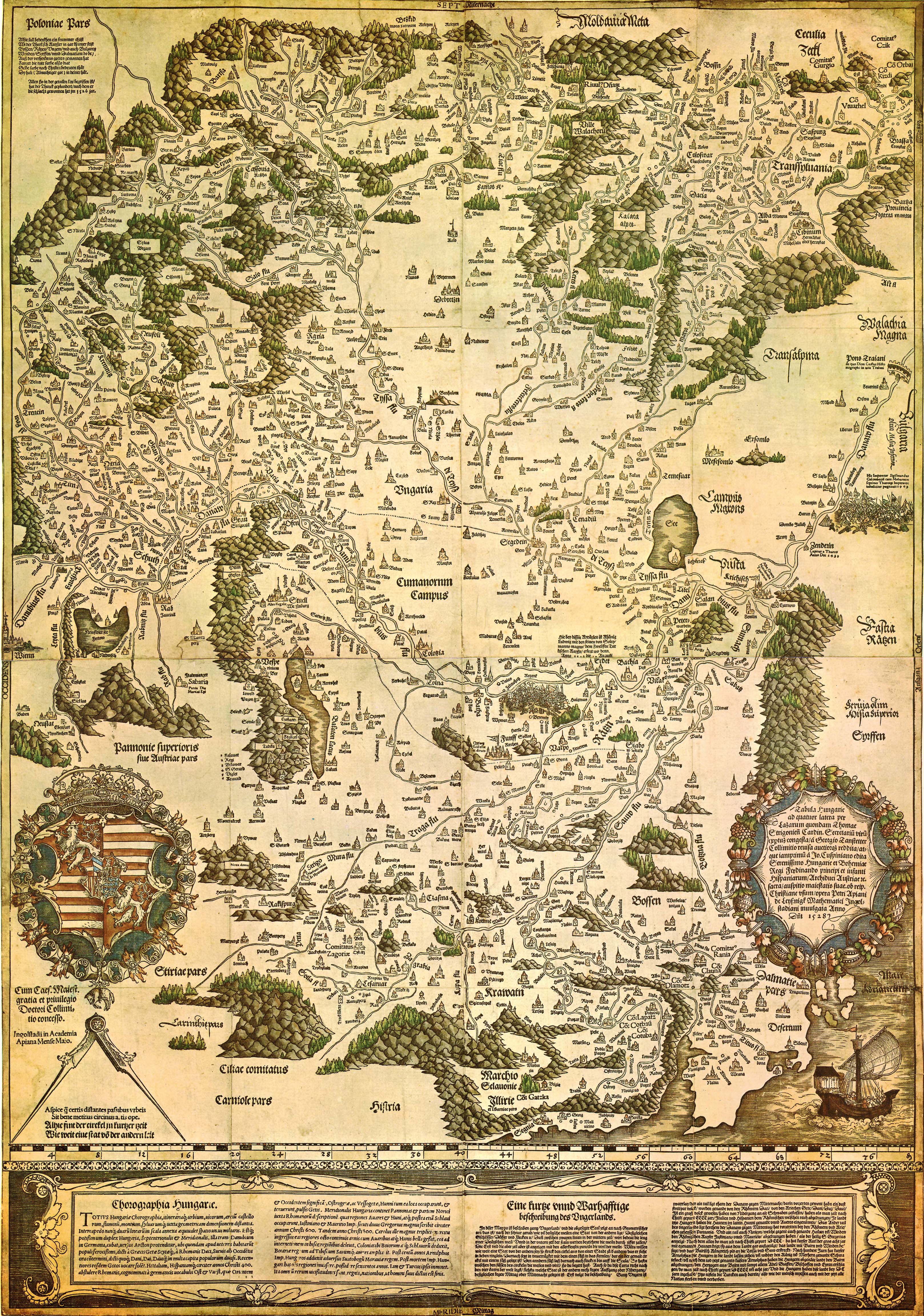
| Tabula Hungariae
|
||
|---|---|---|
| Autoría |
Lázár deák (Lazarus secretarius) |
 |
| Título |
latín: Tabula Hungarie ad quatuor latera Tabula Hungariae |
|
| Impresor | ||
| Tipo de objecto |
mapa antigo |
|
| Descrición |
Magyar: A Tabula Hungariae vagy Lázár térképe Magyarország első nyomtatott térképe, amelyet a feltehetően a magyar Lázár deák készített Српски / srpski: Lazarusova karta Ugarske iz 1528. godine na kojoj je na mestu današnjeg Novog Sada ubeleženo naselje Bistritz (Bistrica) |
|
| Data | entre 1526 e 1528 | |
| Data de publicación |
1528 |
|
| Colección | ||
| Referencias | ||
| Control de autoridade | ||
| Orixe/Fotógrafo | http://lazarus.elte.hu/hun/maps/lazar150.jpg | |
| Outras versións |
|
|


Licenza
|
Este material está no dominio público nos demais países onde os dereitos de autor se estenden por 100 anos (ou menos) trala morte do autor. Este arquivo está no dominio público nos Estados Unidos xa que foi publicado antes do 1 de xaneiro de 1929. | |
| Este ficheiro foi identificado como libre de restricións baixo as leis de dereitos de autor, incluídos todos os dereitos relacionados. | |
Historial do ficheiro
Prema nunha data/hora para ver o ficheiro tal e como estaba nese momento.
| Data/Hora | Miniatura | Dimensións | Usuario | Comentario | |
|---|---|---|---|---|---|
| actual | 29 de agosto de 2009 ás 23:02 | | 3.236 × 4.609 (3,27 MB) | Qorilla | {{Information |Description={{en|1=Tabula Hungariae, first printed map of Hungary}} |Source=Hungarian Wikipedia |Author=Lázár deák (Lazarus secretarius) |Date=somewhere between 1526-1528 |Permission= |other_versions= }} Category:Old maps of Hungary |
Uso do ficheiro
Non hai páxinas que usen este ficheiro.
Uso global do ficheiro
Os seguintes wikis empregan esta imaxe:
- Uso en ar.wikipedia.org
- Uso en bn.wikipedia.org
- Uso en bs.wikipedia.org
- Uso en ca.wikipedia.org
- Uso en de.wikipedia.org
- Uso en el.wikipedia.org
- Uso en en.wikipedia.org
- Pannonia
- Treaty of Trianon
- Hungarian Revolution of 1956
- Austro-Hungarian Compromise of 1867
- Military Frontier
- Hungarian nobility
- History of Hungary before the Hungarian conquest
- Hungarian prehistory
- Kingdom of Hungary (1526–1867)
- History of geography
- Georg Tannstetter
- Upper Hungary
- History of the Jews in Hungary
- Music history of Hungary
- Bistrica, Novi Sad
- Lands of the Crown of Saint Stephen
- History of Transylvania
- Template:History of Hungary
- Hungarian People's Republic
- Principality of Transylvania (1570–1711)
- Military history of Hungary
- First Hungarian Republic
- Ottoman Hungary
- Hungary between the World Wars
- Principality of Hungary
- Hungarian Revolution of 1848
- Rákóczi's War of Independence
- Eastern Hungarian Kingdom
- Kingdom of Hungary (1920–1946)
- Hungary in World War I
- Second Hungarian Republic
Ollar o uso global deste ficheiro.