
Ficheiro:Sud Italia nel 1112.jpg
Tamaño desta vista previa: 529 × 600 píxeles. Outras resolucións: 212 × 240 píxeles | 423 × 480 píxeles | 712 × 807 píxeles.
Ficheiro orixinal (712 × 807 píxeles; tamaño do ficheiro: 94 kB; tipo MIME: image/jpeg)
| Este ficheiro procede de Wikimedia Commons. A continuación móstrase a información da súa páxina de descrición. Commons é un repositorio libre de ficheiros multimedia. Pode contribuír alí cargando as súas imaxes. |
Resumo
| Descrición |
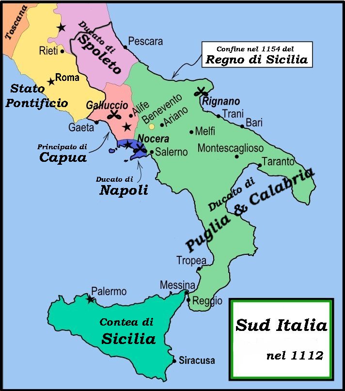
English: This is a political map of southern Italy in 1112 AD/CE, the date when Roger II of Sicily reached his age of majority, also showing the border of the Kingdom of Sicily in 1154, on his death.
"The rarity of surviving records makes it impossible to draw a map of comital [counts'] responsibiities in southern Italy at the beginning of the twelth century." Matthew, p. 23. As noted by Matthew, the political situation in southern Italy is much more complex than this map shows. There were numerous counts and semi-independent cities throughout the region. Moreover, the near-constant rebellions and conquests continually re-arranged the map. |
| Data | |
| Orixe | File:Southern Italy 1112.svg MapMaster |
| Autoría | MapMaster |
| Outras versións |
[]
|


References
- Bjorklund, Oddvar; Holmboe, Haakon; Rohr, Anders (1970) Historical Atlas of the World, Barnes & Noble, NY, SBN: 389-00253-4.
- Houben, Hubert (translated by Graham A. Loud and Diane Milburn), (2002) Roger II of Sicily: Ruler between East and West, Cambridge University Press.
- Konstam, Angus (2000) Atlas of Medieval Europe, Checkmark Books, New York.
- Matthew, Donald (1992) The Norman Kingdom of Sicily Cambridge Medieval Textbooks.
Licenza
Eu, como posuidor dos dereitos de autor desta obra, pola presente publícoa baixo as seguintes licenzas:

|
Autorízase a copia, distribución e/ou modificación deste documento baixo os termos da licenza de documentación libre GNU, versión 1.2 ou calquera outra que posteriormente publique a Free Software Foundation; sen seccións invariables, textos de portada, nin textos de contraportada. Inclúese unha copia da devandita licenza na sección titulada GNU Free Documentation License. |
This file is licensed under the Creative Commons Attribution-Share Alike 4.0 International, 3.0 Unported, 2.5 Generic, 2.0 Generic and 1.0 Generic license.
- Vostede é libre de:
- compartir – copiar, distribuír e difundir a obra
- facer obras derivadas – adaptar a obra
- Baixo as seguintes condicións:
- recoñecemento – Debe indicar a debida atribución de autoría, fornecer unha ligazón á licenza e indicar se se realizaron cambios. Pode facer isto de calquera forma razoable, mais non nunha forma que indique que quen posúe a licenza apoia ou subscribe o seu uso da obra.
- compartir igual – Se altera, transforma ou amplía este contido, debe publicar as súas contribucións baixo a mesma licenza ou outra compatible á orixinal.
Pode seleccionar a licenza que desexe.
Historial do ficheiro
Prema nunha data/hora para ver o ficheiro tal e como estaba nese momento.
| Data/Hora | Miniatura | Dimensións | Usuario | Comentario | |
|---|---|---|---|---|---|
| actual | 1 de marzo de 2008 ás 18:59 | | 712 × 807 (94 kB) | Franco aq | {{Information |Description= |Source=Wikimedia Commons |Date=01 03 2008 |Author=User:MapMaster |other_versions=Image:Southern Italy 1112.svg }} |
Uso do ficheiro
As seguintes 2 páxinas usan este ficheiro:
Uso global do ficheiro
Os seguintes wikis empregan esta imaxe:
- Uso en arz.wikipedia.org
- Uso en bg.wikipedia.org
- Uso en br.wikipedia.org
- Uso en ca.wikipedia.org
- Uso en co.wikipedia.org
- Uso en de.wikipedia.org
- Uso en el.wikipedia.org
- Uso en fr.wikipedia.org
- Uso en hu.wikipedia.org
- Uso en it.wikipedia.org
- Napoli
- Rainulfo di Alife
- Sovrani dei regni di Sicilia e di Napoli
- Antichi Stati italiani
- Montescaglioso
- Ducato di Napoli
- Regno di Sicilia
- Terra di Lavoro
- Storia di Napoli
- Principato di Capua
- Roberto II di Capua
- Battaglia di Nocera
- Alfonso d'Altavilla
- Suddivisione amministrativa del Regno di Napoli
- Contea di Sicilia
- Ducato di Puglia e Calabria
- Storia della Campania
- Cortimpiano
- Resti e reperti archeologici della metropolitana di Napoli
- Utente:Memnone di Rodi/Sandbox/Napoli
- Contea di Tricarico
- Sovrani italiani
- Giordano II di Capua
- Cronologia della storia di Teramo
- Uso en lt.wikipedia.org
- Uso en nl.wikipedia.org
- Uso en pl.wikipedia.org
- Uso en uk.wikipedia.org
- Uso en vi.wikipedia.org