
Ficheiro:Precipitation Ohio NA.png

Tamaño desta vista previa: 711 × 599 píxeles. Outras resolucións: 285 × 240 píxeles | 570 × 480 píxeles | 911 × 768 píxeles | 1.215 × 1.024 píxeles | 1.578 × 1.330 píxeles.
Ficheiro orixinal (1.578 × 1.330 píxeles; tamaño do ficheiro: 211 kB; tipo MIME: image/png)
| Este ficheiro procede de Wikimedia Commons. A continuación móstrase a información da súa páxina de descrición. Commons é un repositorio libre de ficheiros multimedia. Pode contribuír alí cargando as súas imaxes. |
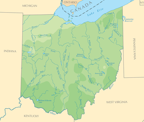
| Descrición | Map of Ohio (Precipitation) |
| Orixe | National Atlas |
| Autoría | National Atlas |
| Licenza (Reuso deste ficheiro) |
PD |
This map was obtained from an edition of the National Atlas of the United States. Like almost all works of the U.S. federal government, works from the National Atlas are in the public domain in the United States.
Online access: NationalAtlas.gov | 1970 print edition: Library of Congress, Perry-Castañeda Library
|
Historial do ficheiro
Prema nunha data/hora para ver o ficheiro tal e como estaba nese momento.
| Data/Hora | Miniatura | Dimensións | Usuario | Comentario | |
|---|---|---|---|---|---|
| actual | 2 de xaneiro de 2010 ás 16:19 | | 1.578 × 1.330 (211 kB) | Shell Kinney | borders removed |
| 12 de setembro de 2006 ás 19:45 |  | 2.112 × 1.632 (332 kB) | Mortadelo2005 | {{Information| |Description=Map of Ohio (Precipitation) |Source=[http://www.nationalatlas.gov National Atlas]|Date= |Author=National Atlas |Permission=PD }} Category:Maps of Ohio {{PD-USGov-Atlas}} |
Uso do ficheiro
A seguinte páxina usa este ficheiro:
Uso global do ficheiro
Os seguintes wikis empregan esta imaxe:
- Uso en bg.wikipedia.org
- Uso en es.wikipedia.org