
Ficheiro:Newyork heat island.jpg

Tamaño desta vista previa: 298 × 598 píxeles. Outras resolucións: 119 × 240 píxeles | 540 × 1.084 píxeles.
Ficheiro orixinal (540 × 1.084 píxeles; tamaño do ficheiro: 149 kB; tipo MIME: image/jpeg)
| Este ficheiro procede de Wikimedia Commons. A continuación móstrase a información da súa páxina de descrición. Commons é un repositorio libre de ficheiros multimedia. Pode contribuír alí cargando as súas imaxes. |
Resumo
| Descrición |
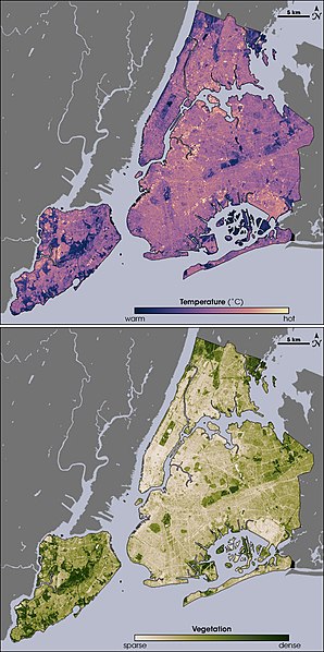
English: Thermal infrared satellite data measured by NASAâs Landsat Enhanced Thematic Mapper Plus on August 14, 2002 one of the hottest days in New York City's summer. Landsat also collected vegetation data. Image from NASA EArth Observatory web page <http://earthobservatory.nasa.gov/Newsroom/NewImages/images.php3?img_id=17354> --Ryanjo 23:43, 1 August 2006 (UTC) |
| Orixe | NASA |
| Autoría | |
| Outras versións |
 |
Licenza
| Este ficheiro está no dominio público porque foi creado pola NASA. A política do copyright da NASA declara que "o material da NASA non está protexido polos dereitos de autor a non ser que se indique o contrario". (Páxina de políticas do copyright da NASA ou política de uso de imaxes JPL). | ||
 |
Avisos:
|
Rexistro de cargas orixinal
A páxina orixinal de descrición está aquí. Tódolos seguintes nomes de usuario refírense a en.wikipedia.
- 2006-08-01 23:43 Ryanjo 540×1084× (152802 bytes) Thermal infrared satellite data measured by NASAâs Landsat Enhanced Thematic Mapper Plus on August 14, 2002 one of the hottest days in New York City's summer. Landsat also collected vegetation data. Image from NASA EArth Observatory web page <http://ear
Historial do ficheiro
Prema nunha data/hora para ver o ficheiro tal e como estaba nese momento.
| Data/Hora | Miniatura | Dimensións | Usuario | Comentario | |
|---|---|---|---|---|---|
| actual | 23 de febreiro de 2009 ás 14:49 | | 540 × 1.084 (149 kB) | File Upload Bot (Magnus Manske) | {{BotMoveToCommons|en.wikipedia|year={{subst:CURRENTYEAR}}|month={{subst:CURRENTMONTHNAME}}|day={{subst:CURRENTDAY}}}} {{Information |Description={{en|Thermal infrared satellite data measured by NASAâs Landsat Enhanced Thematic Mapper Plus on August |
Uso do ficheiro
A seguinte páxina usa este ficheiro:
Uso global do ficheiro
Os seguintes wikis empregan esta imaxe:
- Uso en af.wikipedia.org
- Uso en ca.wikipedia.org
- Uso en da.wikipedia.org
- Uso en en.wikipedia.org
- Uso en eo.wikipedia.org
- Uso en et.wikipedia.org
- Uso en fa.wikipedia.org
- Uso en fr.wikipedia.org
- Uso en fr.wikibooks.org
- Uso en he.wikipedia.org
- Uso en hr.wikipedia.org
- Uso en ja.wikipedia.org
- Uso en ko.wikipedia.org
- Uso en ms.wikipedia.org
- Uso en nn.wikipedia.org
- Uso en ta.wikipedia.org
- Uso en th.wikipedia.org
- Uso en zh.wikipedia.org