
Ficheiro:Map provinces Netherlands-en.svg

Tamaño desta vista previa en PNG do ficheiro en formato SVG: 506 × 600 píxeles. Outras resolucións: 202 × 240 píxeles | 405 × 480 píxeles | 648 × 768 píxeles | 864 × 1.024 píxeles | 1.727 × 2.048 píxeles | 743 × 881 píxeles.
Ficheiro orixinal (ficheiro SVG; resolución de 743 × 881 píxeles; tamaño do ficheiro: 1.003 kB)
| Este ficheiro procede de Wikimedia Commons. A continuación móstrase a información da súa páxina de descrición. Commons é un repositorio libre de ficheiros multimedia. Pode contribuír alí cargando as súas imaxes. |
Esta imaxe vectorial foi creada co Inkscape .

|
Este ficheiro SVG emprega texto encapsulado que pode ser traducido doadamente a calquera lingua usando un editor SVG como Inkscape ou Adobe Illustrator. Vexa máis información. Tamén pode descargalo e traducilo manualmente empregando un editor de texto. |
Resumo
| Descrición |
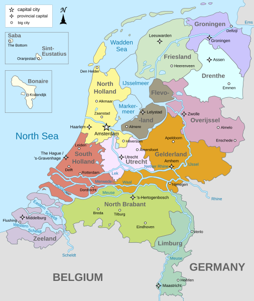
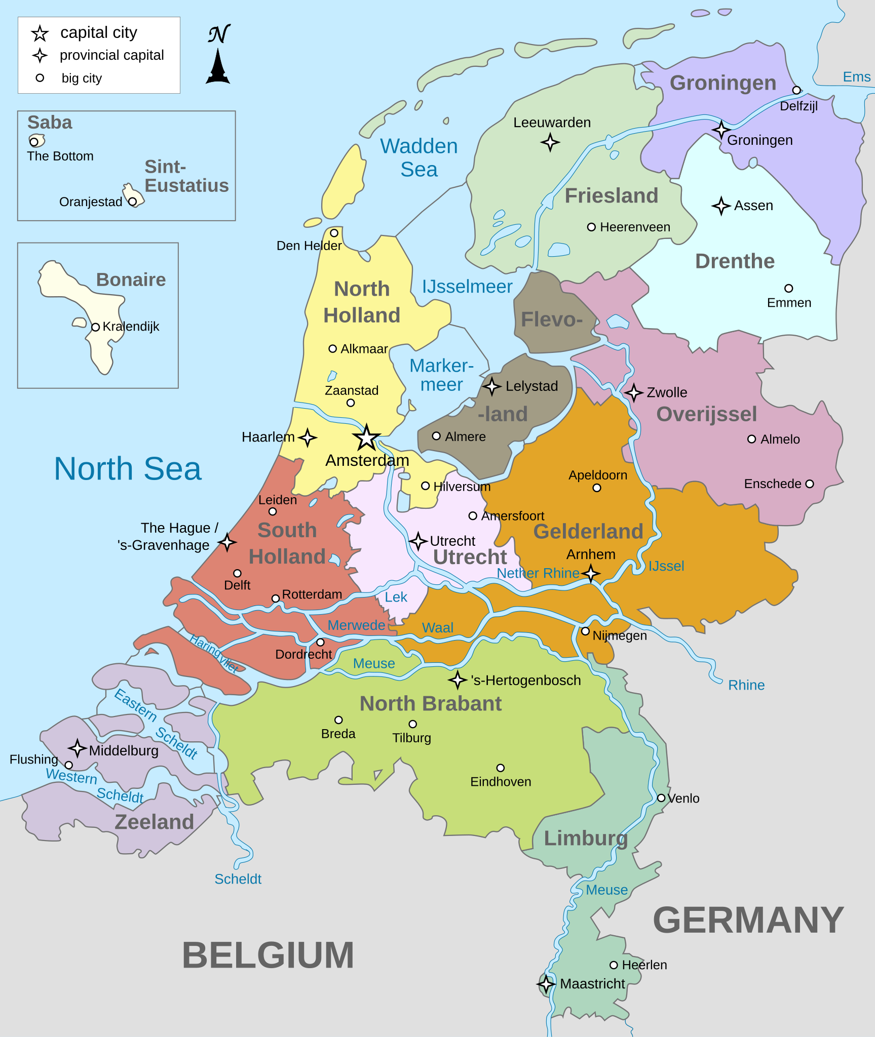
English: Map of The Netherlands (including the special municipalities of Saba, Saint Eustatius and Bonaire; the Caribbean Netherlands), showing provinces, large cities, rivers and lakes. English version
Deutsch: Karte der Niederlande, mit den Provinzen, der Karibischen Niederlande, den Großstädten und den Flüssen und Seen. Englische Version
Bahasa Indonesia: Peta Belanda (termasuk munisipal khusus Saba, Saint Eustatius dan Bonaire; Belanda Karibia), menampilkan provinsi, kota besar, sungai dan danau. Versi bahasa Inggris |
| Data | |
| Orixe | Obra propia |
| Autoría | Alphathon |
| Outras versións |
[]
|


.svg)
Licenza
Eu, como posuidor dos dereitos de autor desta obra, pola presente publícoa baixo as seguintes licenzas:
Este ficheiro está licenciado baixo a licenza Creative Commons recoñecemento compartir igual 3.0 sen adaptar.
- Vostede é libre de:
- compartir – copiar, distribuír e difundir a obra
- facer obras derivadas – adaptar a obra
- Baixo as seguintes condicións:
- recoñecemento – Debe indicar a debida atribución de autoría, fornecer unha ligazón á licenza e indicar se se realizaron cambios. Pode facer isto de calquera forma razoable, mais non nunha forma que indique que quen posúe a licenza apoia ou subscribe o seu uso da obra.
- compartir igual – Se altera, transforma ou amplía este contido, debe publicar as súas contribucións baixo a mesma licenza ou outra compatible á orixinal.

|
Autorízase a copia, distribución e/ou modificación deste documento baixo os termos da licenza de documentación libre GNU, versión 1.2 ou calquera outra que posteriormente publique a Free Software Foundation; sen seccións invariables, textos de portada, nin textos de contraportada. Inclúese unha copia da devandita licenza na sección titulada GNU Free Documentation License. |
Pode seleccionar a licenza que desexe.
Historial do ficheiro
Prema nunha data/hora para ver o ficheiro tal e como estaba nese momento.
| Data/Hora | Miniatura | Dimensións | Usuario | Comentario | |
|---|---|---|---|---|---|
| actual | 19 de xaneiro de 2024 ás 19:28 | | 743 × 881 (1.003 kB) | Illchy | File uploaded using svgtranslate tool (https://svgtranslate.toolforge.org/). Added translation for id. |
| 29 de abril de 2023 ás 17:43 |  | 743 × 881 (987 kB) | Dymitr | File uploaded using svgtranslate tool (https://svgtranslate.toolforge.org/). Added translation for be-tarask. | |
| 25 de novembro de 2021 ás 09:27 |  | 743 × 881 (909 kB) | Andrei Stroe | File uploaded using svgtranslate tool (https://svgtranslate.toolforge.org/). Added translation for ro. | |
| 12 de abril de 2019 ás 08:39 |  | 743 × 881 (811 kB) | Thayts | Tweaked text position | |
| 17 de febreiro de 2019 ás 11:32 |  | 743 × 881 (811 kB) | Thayts | Fixed svg | |
| 17 de febreiro de 2019 ás 11:18 |  | 743 × 881 (811 kB) | Thayts | Added a bit more spacing between Eastern/Western and Scheldt | |
| 17 de febreiro de 2019 ás 11:06 |  | 743 × 881 (811 kB) | Thayts | Fixed Eastern Scheldt which wasn't rendered by the MediaWiki engine; removed Belgian city of Antwerp | |
| 14 de febreiro de 2019 ás 05:21 |  | 743 × 881 (809 kB) | Alphathon | Updated borders | |
| 23 de agosto de 2015 ás 20:34 |  | 743 × 881 (847 kB) | Alphathon | Fixed stroke weight on a Friesland lake | |
| 23 de agosto de 2015 ás 20:27 |  | 743 × 881 (847 kB) | Alphathon | Covered over the strokes at the mouths of rivers |
Uso do ficheiro
As seguintes 2 páxinas usan este ficheiro:
Uso global do ficheiro
Os seguintes wikis empregan esta imaxe:
- Uso en ace.wikipedia.org
- Uso en af.wikipedia.org
- Uso en ang.wikipedia.org
- Uso en an.wikipedia.org
- Uso en ar.wikipedia.org
- Uso en ay.wikipedia.org
- Uso en azb.wikipedia.org
- Uso en be-tarask.wikipedia.org
- Uso en bg.wikipedia.org
- Uso en blk.wikipedia.org
- Uso en bn.wikipedia.org
- Uso en ceb.wikipedia.org
- Uso en diq.wikipedia.org
- Uso en en.wikipedia.org
- Netherlands
- Provinces of the Netherlands
- List of islands of the Netherlands
- King's commissioner
- Geology of the Netherlands
- File talk:Netherlands map large.png
- French war planning 1920–1940
- User talk:Gidonb/Archive 2008
- Template:Provinces of the Netherlands imagemap
- List of windmills in the Netherlands
- Provincial politics in the Netherlands
- 2008–09 KNVB Cup
- User:Alphathon/Gallery
- File talk:Netherlands Map.svg
- Portal:Islands
- Wikipedia:Reference desk/Archives/Humanities/2014 September 25
- Uso en en.wikiversity.org
- Uso en eu.wikipedia.org
- Uso en fa.wikipedia.org
- Uso en fi.wikipedia.org
- Uso en fr.wikipedia.org
- Uso en haw.wikipedia.org
- Uso en he.wikipedia.org
- Uso en ia.wikipedia.org
- Uso en id.wikipedia.org
Ollar o uso global deste ficheiro.