
Ficheiro:Map of Jewish settlements in Palestine in 1947.png
Non se pode ver nunha resolución meirande.
Map_of_Jewish_settlements_in_Palestine_in_1947.png (312 × 556 píxeles; tamaño do ficheiro: 59 kB; tipo MIME: image/png)
| Este ficheiro procede de Wikimedia Commons. A continuación móstrase a información da súa páxina de descrición. Commons é un repositorio libre de ficheiros multimedia. Pode contribuír alí cargando as súas imaxes. |
Resumo
| Descrición |
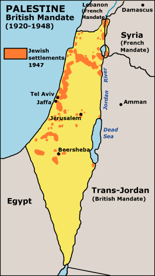
English: Map of Jewish settlements in Palestine in 1947. |
| Data | 2 de outubro de 2003 (data de subida orixinal) |
| Orixe | Transferido de en.wikipedia a Wikimedia Commons empregando CommonsHelper. |
| Autoría | JamesDay em Wikipedia em inglés |
| Licenza (Reuso deste ficheiro) |
GFDL derivative work created by the uploader based on a portion of the public domain work http://www.lib.utexas.edu/maps/historical/israel_hist_1973.jpg . At http://www.lib.utexas.edu/maps/faq.html that site states that "Most of the maps scanned by the General Libraries and served from this web site are in the public domain. No permissions are needed to copy them. You may download them and use them as you wish. A few maps are copyrighted, and are clearly marked as such". There is no such mark with this map, so it is presumed to have been in the public domain before the derivative work was created. The uploader hereby releases the derivative work under the GFDL. |
Licenza

|
Autorízase a copia, distribución e/ou modificación deste documento baixo os termos da licenza de documentación libre GNU, versión 1.2 ou calquera outra que posteriormente publique a Free Software Foundation; sen seccións invariables, textos de portada, nin textos de contraportada. Inclúese unha copia da devandita licenza na sección titulada GNU Free Documentation License. |
| Este ficheiro está licenciado baixo a licenza Creative Commons recoñecemento compartir igual 3.0 sen adaptar. | ||
| Recoñecemento: Wikipedia user JamesDay | ||
| ||
| A etiqueta desta licenza engadiuse a este ficheiro como parte da actualización da licenza GFDL. |
Rexistro de cargas orixinal
A páxina orixinal de descrición está aquí. Tódolos seguintes nomes de usuario refírense a en.wikipedia.
- 2005-09-27 18:47 Doviende 312×556× (60723 bytes) changed from indexed colour to RGB and traced the lines again so they aren't so choppy. Also redid all the text so it's anti-aliased better.
- 2003-10-02 14:18 JamesDay 312×556× (11422 bytes) Map of Jewish settlements in Palestine in 1947.
Historial do ficheiro
Prema nunha data/hora para ver o ficheiro tal e como estaba nese momento.
| Data/Hora | Miniatura | Dimensións | Usuario | Comentario | |
|---|---|---|---|---|---|
| actual | 18 de decembro de 2006 ás 16:13 | | 312 × 556 (59 kB) | Electionworld | {{ew|en|JamesDay}} Map of Jewish settlements in Palestine in 1947. Copyright: GFDL derivative work created by the uploader based on a portion of the public domain work http://www.lib.utexas.edu/maps/historical/israel_hist_1973.jpg . At http://www.lib.ute |
Uso do ficheiro
A seguinte páxina usa este ficheiro:
Uso global do ficheiro
Os seguintes wikis empregan esta imaxe:
- Uso en als.wikipedia.org
- Uso en ast.wikipedia.org
- Uso en de.wikipedia.org
- Uso en en.wikipedia.org
- Uso en es.wikipedia.org
- Uso en fi.wikipedia.org
- Uso en it.wikipedia.org
- Uso en sq.wikipedia.org
- Uso en stq.wikipedia.org