
Ficheiro:Map Crusader states 1135-es.svg

Tamaño desta vista previa en PNG do ficheiro en formato SVG: 435 × 599 píxeles. Outras resolucións: 174 × 240 píxeles | 348 × 480 píxeles | 558 × 768 píxeles | 744 × 1.024 píxeles | 1.487 × 2.048 píxeles | 955 × 1.315 píxeles.
Ficheiro orixinal (ficheiro SVG; resolución de 955 × 1.315 píxeles; tamaño do ficheiro: 428 kB)
| Este ficheiro procede de Wikimedia Commons. A continuación móstrase a información da súa páxina de descrición. Commons é un repositorio libre de ficheiros multimedia. Pode contribuír alí cargando as súas imaxes. |
Resumo
| Descrición |
[]
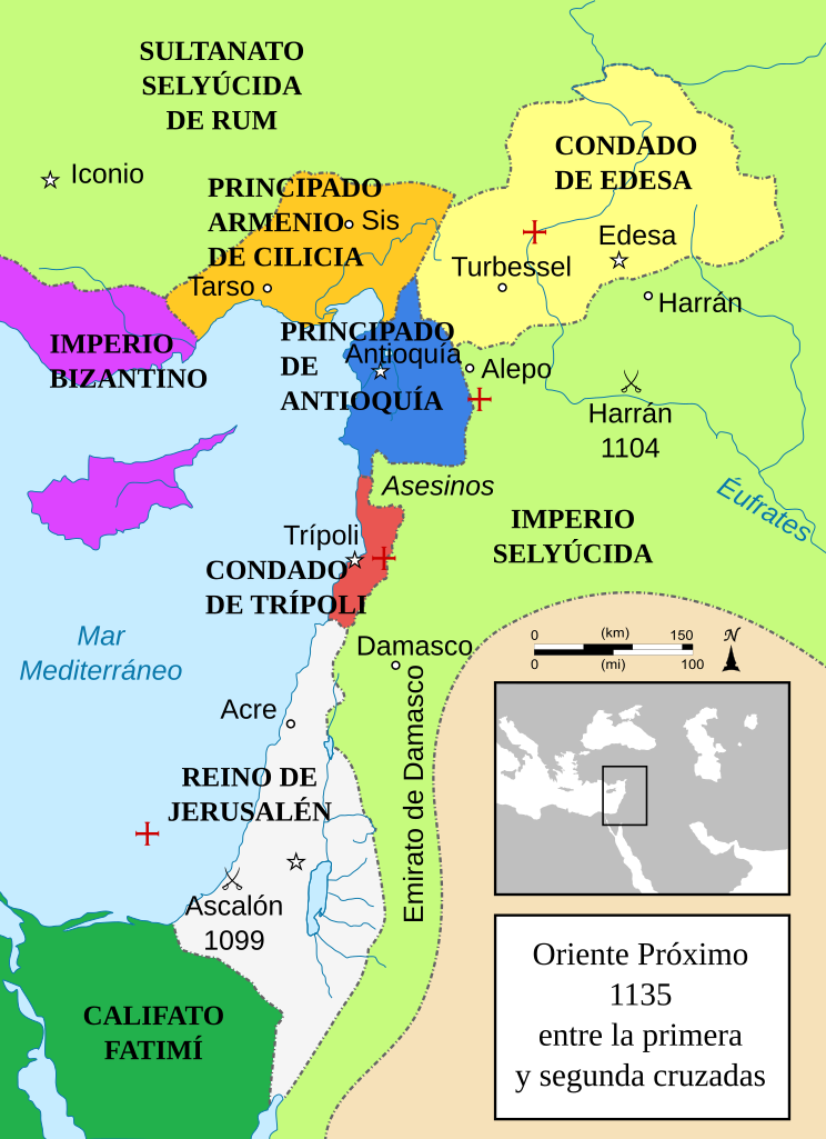
Čeština: Politická mapa Blízkého východu v roce 1135. Deutsch: Die Levante, 1135, zwischen den Ersten und Zweiten Kreuzzügen. Kreuzzugsstaaten sind mit einem roten Kreuz gekennzeichnet Eesti: Lähis-Ida (1135) Español: Oriente Próximo en 1135, entre la primera y segunda cruzadas. Esperanto: Politika mapo de Levantenio dum 1135, inter la krucmilitaroj unuaj kaj duaj. Français : Carte politique du Proche-Orient en 1135, entre la Première et la Seconde Croisades. les États latins d'Orient sont marqués d'une croix rouge. Italiano: Carta politica del Vicino Oriente nel 1135. Magyar: A Közel-Kelet térképe 1135-ben. Polski: Mapa polityczna Bliskiego Wschodu w roku 1135, w okresie II krucjaty. Ελληνικά: Πολιτικός χάρτης της Μέσης Ανατολής το 1135, ανάμεσα στην πρώτη και τη δεύτερη Σταυροφορία Македонски: Политичка карта на Блискиот Исток во 1135 г. Крстоносните држави се означени со црвени крстови. Русский: Карта Ближнего Востока в 1135 г. Српски / srpski: Politička karta Bliskog Istoka 1135. godine, između Prvog i Drugog krstaškog pohoda. Krstaške države su označene crvenim krstom. ქართული: ახლო აღმოსავლეთი 1135 წელს ไทย: แผนที่ตะวันออกกลาง (คศ. 1135) ระหว่างครูเสดครั้งที่ 1 และครั่งที่ 2 中文: 一副关于1135年近东地区局势的地图,标注红色十字的为十字军国家 العربية : الدويلات الصليبية والدول الإسلامية المجاورة لها في الفترة بين الحملتين الصليبيتين الأولى والثانية. فارسی : نسخه فارسی |
||
| Data | (UTC) | ||
| Orixe |
Este ficheiro derivou de: Near East 1135.svg:  |
||
| Autoría |
|
||
| Outras versións |
[]
See also |


-ka.png)


| Esta é unha imaxe retocada,en o que significa que a súa versión orixinal foi alterada dixitalmente. Modificacións: translated into Spanish and text turned into real text (editable), some minor text added. A orixinal pódese ver aquí: Near East 1135.svg. As modificacións realizounas Rowanwindwhistler.
|
Licenza
Este ficheiro está licenciado baixo a licenza Creative Commons recoñecemento compartir igual 3.0 sen adaptar.
- Vostede é libre de:
- compartir – copiar, distribuír e difundir a obra
- facer obras derivadas – adaptar a obra
- Baixo as seguintes condicións:
- recoñecemento – Debe indicar a debida atribución de autoría, fornecer unha ligazón á licenza e indicar se se realizaron cambios. Pode facer isto de calquera forma razoable, mais non nunha forma que indique que quen posúe a licenza apoia ou subscribe o seu uso da obra.
- compartir igual – Se altera, transforma ou amplía este contido, debe publicar as súas contribucións baixo a mesma licenza ou outra compatible á orixinal.
Rexistro de cargas orixinal
This image is a derivative work of the following images:
- File:Near_East_1135.svg licensed with Cc-by-sa-3.0-migrated, GFDL
- 2012-07-25T09:13:10Z HorsefaCe 955x1315 (428529 Bytes) Cilicia wan't a kingdom yet
- 2012-07-25T09:08:37Z HorsefaCe 955x1315 (123164 Bytes) A Chinese version.
- 2010-07-12T11:48:22Z Richardprins 955x1315 (428529 Bytes) Cilicia wan't a kingdom yet
- 2010-07-12T10:59:43Z Richardprins 955x1315 (433931 Bytes) Corrected burid dynasty
- 2010-07-11T22:01:12Z Richardprins 955x1315 (427612 Bytes) Final tweaks
- 2010-07-11T21:52:48Z Richardprins 955x1315 (412162 Bytes) Now complies with w3c so I hope the box is gone
- 2010-07-11T21:22:15Z Richardprins 955x1315 (412660 Bytes) Trying to remove black box
- 2010-07-11T21:18:22Z Richardprins 955x1315 (411612 Bytes) Forgot to convert Med. sea and Euphrates to path
- 2010-07-11T21:15:30Z Richardprins 955x1315 (379595 Bytes) Revision of colors, borders, font, font colors, scale, battle icons, capital icons, city icons, size of crosses. Arrow pointing north added
- 2010-07-10T18:59:48Z Richardprins 955x1315 (515800 Bytes) minor changes and improvements
- 2010-07-10T18:40:26Z Richardprins 955x1315 (515744 Bytes) The coastline was on top of the text and stuff
- 2010-07-10T18:34:32Z Richardprins 955x1315 (515744 Bytes) Changed water color to convention, river color as well. Added blue coastline, changed Byzantine Empire color back
- 2010-07-07T21:30:17Z Richardprins 955x1315 (492798 Bytes) Final colors
- 2010-07-07T21:09:55Z Richardprins 955x1315 (492618 Bytes) Different colors
- 2010-07-07T20:51:08Z Richardprins 955x1315 (492618 Bytes) Changed arabian graytone, revealed some text, changed seljuk empire color
- 2010-07-07T20:45:40Z Richardprins 955x1315 (467821 Bytes) Changed "Caliphate" size, removed black bar, changed seljuq empire color
- 2010-07-07T20:38:56Z Richardprins 955x1315 (468023 Bytes) Wikified text and colors, corrected some names, changed battle icons to official ones, adjusted colors to more logical ones, added red cross next to crusades state names, moved some text around to make city names better visib
- 2008-02-13T04:42:03Z MapMaster 978x1330 (572232 Bytes) Better colors
- 2007-02-01T05:02:58Z MapMaster 978x1330 (572069 Bytes) A number of upgrades
- 2007-02-01T00:23:37Z MapMaster 978x1330 (563572 Bytes) A political map of the [[w:en:Near East]] in 1135 [[w:en:Common Era|CE]].
Carregada com derivativeFX
Historial do ficheiro
Prema nunha data/hora para ver o ficheiro tal e como estaba nese momento.
| Data/Hora | Miniatura | Dimensións | Usuario | Comentario | |
|---|---|---|---|---|---|
| actual | 31 de xullo de 2019 ás 17:48 | | 955 × 1.315 (428 kB) | Rowanwindwhistler | Fake text added |
| 28 de marzo de 2013 ás 21:10 |  | 955 × 1.315 (184 kB) | Rowanwindwhistler | == {{int:filedesc}} == {{Information |Description={{es|1=Oriente Próximo en 1135, entre la primera y segunda cruzadas.}} |Source={{Derived from|Near_East_1135.svg|display=50}} |Date=2013-03-28 21:08 (UTC) |Author=*File:Near_East_1135.svg: '''[[U... |
Uso do ficheiro
A seguinte páxina usa este ficheiro:
Uso global do ficheiro
Os seguintes wikis empregan esta imaxe:
- Uso en ast.wikipedia.org
- Uso en es.wikipedia.org