
Ficheiro:Lusaka, Zambia ESA23163212.jpeg

Ficheiro orixinal (14.115 × 10.980 píxeles; tamaño do ficheiro: 34,98 MB; tipo MIME: image/jpeg)
| Este ficheiro procede de Wikimedia Commons. A continuación móstrase a información da súa páxina de descrición. Commons é un repositorio libre de ficheiros multimedia. Pode contribuír alí cargando as súas imaxes. |
Resumo
| Descrición |
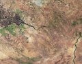
English: The Copernicus Sentinel-2 mission takes us over Lusaka – the capital and largest city of Zambia. Zoom in to see this image at its full 10 m resolution or click on the circles to learn more about the features in it. Lusaka, visible at the top of the image, is located on a high plateau in south-central Africa with an elevation of around 1200 m. With a population of over 2 million people, Lusaka is one of the fastest developing cities in southern Africa. Lusaka National Park is easily identifiable as a brown patch of land just southeast of the city. The 6700 hectare park hosts a variety of rare and endangered animals. Owing to Zambia’s humid sub-tropical climate, agriculture is the country’s main source of income and jobs. The circular shapes in the image, visible mostly southwest of Lusaka in light green, are an example of pivot irrigation, or centre-pivot irrigation systems. This type of irrigation functions where equipment rotates around a central pivot and crops are fed with water from the centre of the arc. Water from the nearby Kafue River, visible cutting across the image from left to right, is used for irrigation and hydroelectric power. At 1600 km long, the Kafue River is the longest river lying solely within Zambia. The river flows across the flat plain called Kafue Flats (also known as Butwa) and meanders in a maze of swampy channels and lagoons. The flats, visible in dark brown in the far-left of the image, are a shallow flood plain around 240 km long and about 50 km wide, and are usually flooded to a depth of less than one metre in the rainy season. From here, the Kafue River continues its journey southeast, flowing through the Kafue Gorge before finally joining the Zambezi River, visible in the bottom-right of the image, near Chirundu, Zimbabwe. Data from the Copernicus Sentinel-2 mission can help monitor changes in urban expansion, land-cover change and agriculture monitoring. The mission’s frequent revisits over the same area and high spatial resolution also allow changes in inland water bodies to be closely monitored. This image, which was captured on 29 July 2019, is also featured on the Earth from Space programme. |
| Data | 19 de febreiro de 2021 (data do carregamento) |
| Orixe | Lusaka, Zambia |
| Autoría | European Space Agency |
| Outras versións |
|
| Activity | Observing the Earth |
| Mission | Sentinel-2 |
| Set | Earth observation image of the week |
| System | Copernicus |
Licenza

|
This image contains data from a satellite in the Copernicus Programme, such as Sentinel-1, Sentinel-2 or Sentinel-3. Attribution is required when using this image.
Recoñecemento: Contains modified Copernicus Sentinel data 2019
The use of Copernicus Sentinel Data is regulated under EU law (Commission Delegated Regulation (EU) No 1159/2013 and Regulation (EU) No 377/2014). Relevant excerpts:
Free access shall be given to GMES dedicated data [...] made available through GMES dissemination platforms [...].
Access to GMES dedicated data [...] shall be given for the purpose of the following use in so far as it is lawful:
GMES dedicated data [...] may be used worldwide without limitations in time.
GMES dedicated data and GMES service information are provided to users without any express or implied warranty, including as regards quality and suitability for any purpose. |
This media was created by the European Space Agency (ESA).
Where expressly so stated, images or videos are covered by the Creative Commons Attribution-ShareAlike 3.0 IGO (CC BY-SA 3.0 IGO) licence, ESA being an Intergovernmental Organisation (IGO), as defined by the CC BY-SA 3.0 IGO licence. The user is allowed under the terms and conditions of the CC BY-SA 3.0 IGO license to Reproduce, Distribute and Publicly Perform the ESA images and videos released under CC BY-SA 3.0 IGO licence and the Adaptations thereof, without further explicit permission being necessary, for as long as the user complies with the conditions and restrictions set forth in the CC BY-SA 3.0 IGO licence, these including that:
See the ESA Creative Commons copyright notice for complete information, and this article for additional details.
|
 | |
Este ficheiro está licenciado baixo a licenza Creative Commons recoñecemento compartir igual 3.0 IGO. Recoñecemento: ESA, CC BY-SA IGO 3.0
| ||
Historial do ficheiro
Prema nunha data/hora para ver o ficheiro tal e como estaba nese momento.
| Data/Hora | Miniatura | Dimensións | Usuario | Comentario | |
|---|---|---|---|---|---|
| actual | 19 de febreiro de 2021 ás 10:28 | | 14.115 × 10.980 (34,98 MB) | OptimusPrimeBot | #Spacemedia - Upload of https://www.esa.int/var/esa/storage/images/esa_multimedia/images/2021/02/lusaka_zambia/23163202-1-eng-GB/Lusaka_Zambia.jpg via Commons:Spacemedia |
Uso do ficheiro
A seguinte páxina usa este ficheiro:
Uso global do ficheiro
Os seguintes wikis empregan esta imaxe:
- Uso en www.wikidata.org