
Ficheiro:Krt 1510 full.jpg

Ficheiro orixinal (4.000 × 3.000 píxeles; tamaño do ficheiro: 14,13 MB; tipo MIME: image/jpeg)
| Este ficheiro procede de Wikimedia Commons. A continuación móstrase a información da súa páxina de descrición. Commons é un repositorio libre de ficheiros multimedia. Pode contribuír alí cargando as súas imaxes. |
Resumo
| Descrición |
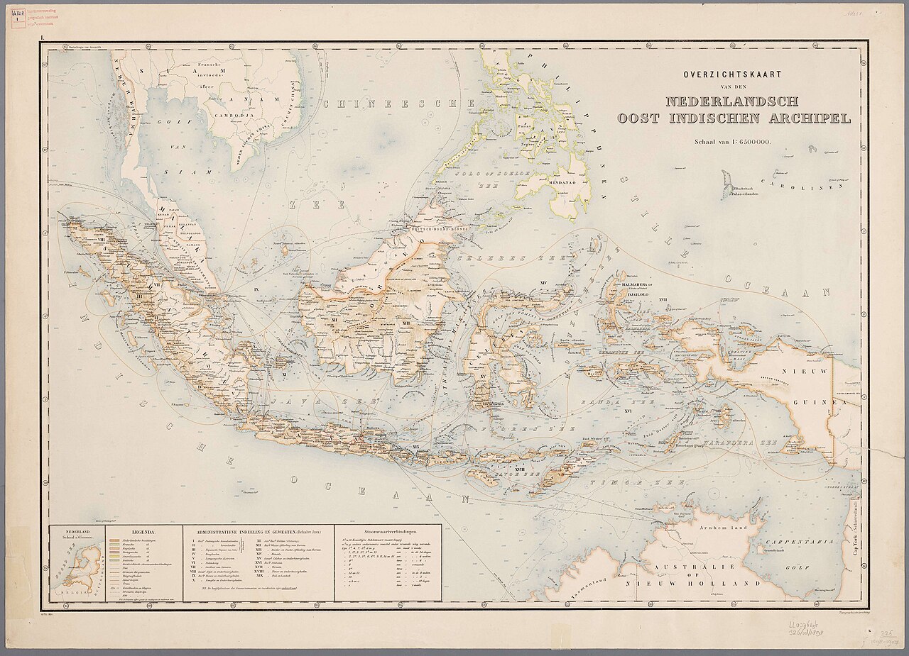
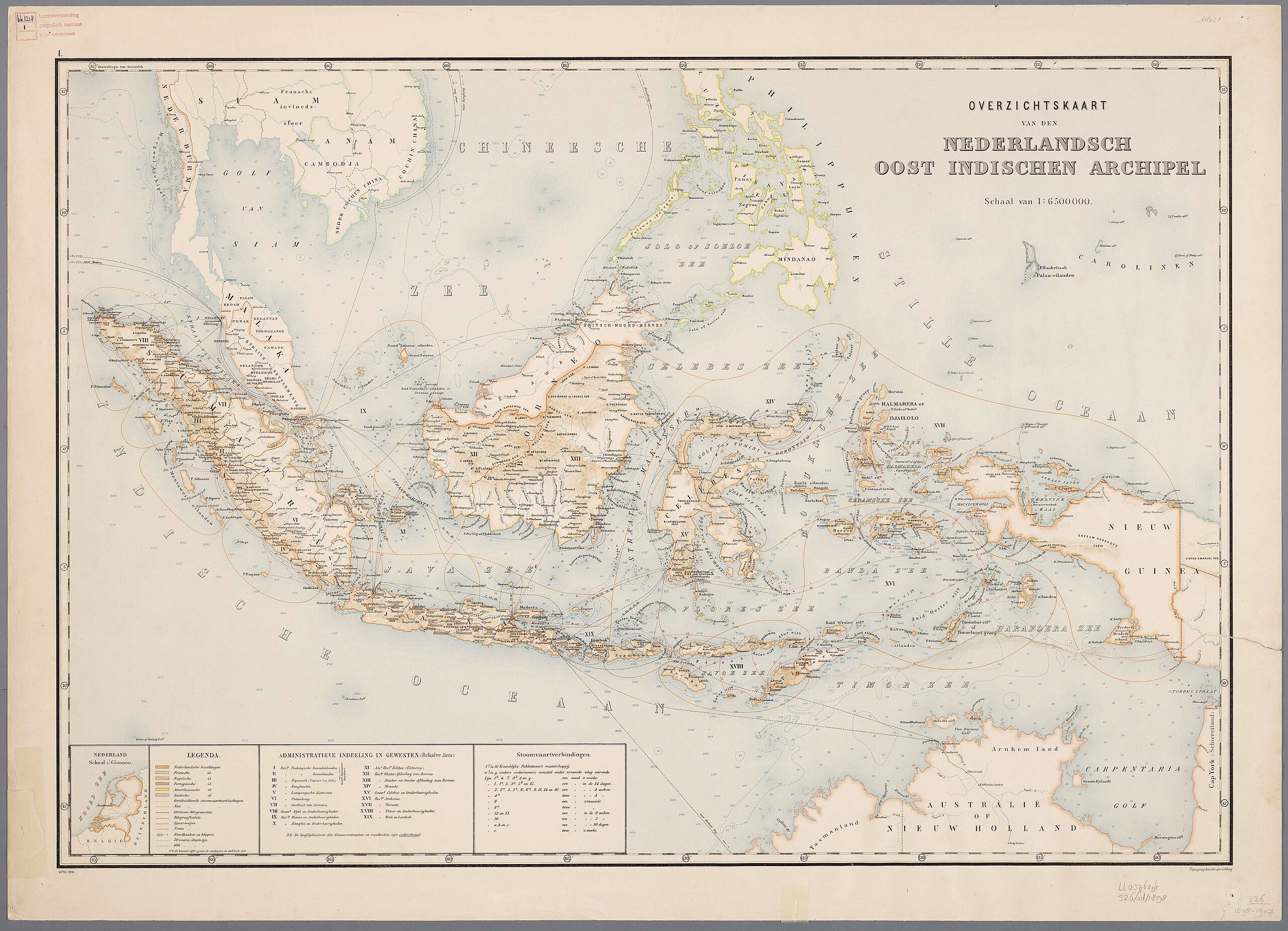
Nederlands: Atlas van Nederlandsch Oost-Indië / samengest. door Topographisch Bureau te Batavia van 1897-1904 |
| Data | 1897-1904 |
| Orixe |
https://vu.contentdm.oclc.org/digital/collection/krt/id/1510 or https://digitalcollections.universiteitleiden.nl/view/item/2014658 restored and enchanced by u/helloVizart |
| Autoría | Topographisch Bureau, Batavia |
| Outras versións |
.jpg)
.jpg)


|
Este material está no dominio público nos demais países onde os dereitos de autor se estenden por 70 anos (ou menos) trala morte do autor.
| |
| Este ficheiro foi identificado como libre de restricións baixo as leis de dereitos de autor, incluídos todos os dereitos relacionados. | |
Historial do ficheiro
Prema nunha data/hora para ver o ficheiro tal e como estaba nese momento.
| Data/Hora | Miniatura | Dimensións | Usuario | Comentario | |
|---|---|---|---|---|---|
| actual | 8 de agosto de 2023 ás 06:44 | | 4.000 × 3.000 (14,13 MB) | Bennylin | restored and enchanced by u/helloVizart |
| 8 de agosto de 2023 ás 06:41 |  | 4.555 × 3.292 (1,81 MB) | Bennylin | {{Information |Description={{nl|Atlas van Nederlandsch Oost-Indië / samengest. door Topographisch Bureau te Batavia van 1897-1904<br /> 1. Overzichtskaart van den Nederlandsch Oost Indischen Archipel}} |Source=https://vu.contentdm.oclc.org/digital/collection/krt/id/1510 |Date=1897-1904 |Author=Topographisch Bureau, Batavia |Permission= |other_versions= }} {{PD-old}} Category:Old maps of Indonesia |
Uso do ficheiro
A seguinte páxina usa este ficheiro:
Uso global do ficheiro
Os seguintes wikis empregan esta imaxe:
- Uso en arz.wikipedia.org
- Uso en ast.wikipedia.org
- Uso en ca.wikipedia.org
- Uso en cy.wikipedia.org
- Uso en dag.wikipedia.org
- Uso en de.wikivoyage.org
- Uso en diq.wikipedia.org
- Uso en el.wikipedia.org
- Uso en en.wikivoyage.org
- Uso en eo.wikipedia.org
- Uso en eo.wikiquote.org
- Uso en fr.wikinews.org
- Uso en fr.wikivoyage.org
- Uso en ga.wikipedia.org
- Uso en ha.wikipedia.org
- Uso en he.wikipedia.org
- Uso en hyw.wikipedia.org
- Uso en ia.wikipedia.org
- Uso en incubator.wikimedia.org
- Uso en it.wikipedia.org
- Uso en kab.wikipedia.org
- Uso en kcg.wikipedia.org
- Uso en kl.wikipedia.org
- Uso en ks.wikipedia.org
- Uso en nqo.wikipedia.org
- Uso en pcm.wikipedia.org
- Uso en rue.wikipedia.org
- Uso en tl.wikipedia.org
- Uso en tly.wikipedia.org
- Uso en tr.wikiquote.org
- Uso en vec.wikipedia.org
- Uso en www.wikidata.org
- Q252
- Wikidata:WikiProject Movies/Numbers
- Wikidata:WikiProject Movies/Numbers/Most frequent P840
- Wikidata:WikiProject Movies/Numbers/Most frequent P915
- User:Zygimantus/Wikidata lists/Example2
- Wikidata:List of 1000 articles every Wikipedia should have
- Wikidata:WikiProject sum of all paintings/Top work locations
- User:Spinster/ASC Leiden Thesaurus
- Wikidata:WikiCite/Wikidata lists/Main subjects of publications with unidentified authors
- User:Walkuraxx/ASC Leiden Thesaurus