
Ficheiro:East and West Florida 1810.jpg
East_and_West_Florida_1810.jpg (412 × 245 píxeles; tamaño do ficheiro: 44 kB; tipo MIME: image/jpeg)
| Este ficheiro procede de Wikimedia Commons. A continuación móstrase a información da súa páxina de descrición. Commons é un repositorio libre de ficheiros multimedia. Pode contribuír alí cargando as súas imaxes. |
| Descrición |
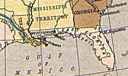
English: Map of East and West Florida in 1810, from the Perry-Castañeda Map Collection [1]. The boundary between the two provinces is incorrect; it was at the Apalachicola River, not the Perdido River (as shown here).
Español: Mapa de Florida Oriental y Florida Occidental en 1810, de la Collección Perry-Castañeda de Mapas[2]. La frontera entre las dos provincias no es correcto; la frontera era el Rio Apalachicola, no el Perdido (como se aparece aquí).
Deutsch: Karte von Ost- und Westflorida 1810. Aus der Kartensammlung der Perry-Castañeda Bibliothek[3]. Die Grenze zwischen Ost- und Westflorida ist unrichtig; die richtige Grenze war der Apalachicola-Fluss anstatt dem Perdido.
Français : Carte de Floride occidentale et de Floride orientale en 1810, provenant de la collection cartographique Perry-Castañeda [4].
La frontière indiquée entre les deux provinces est erronée : elle était formée par le fleuve Apalachicola, et non le fleuve Perdido représenté ici. |
||||||||||||||||||||||
| Data | 1923. Provided on 11 August 2005 by en:User:JW1805 to the English Wikipedia. | ||||||||||||||||||||||
| Orixe | From "The Historical Atlas" by William R. Shepherd, 1923. http://www.lib.utexas.edu/maps/historical/shepherd/us_expansion_shepherd.jpg | ||||||||||||||||||||||
| Autoría |
|
||||||||||||||||||||||
![[1]](http://www.lib.utexas.edu/maps/historical/shepherd/us_expansion_shepherd.jpg)
|
Este material está no dominio público nos demais países onde os dereitos de autor se estenden por 70 anos (ou menos) trala morte do autor.
| |
| Este ficheiro foi identificado como libre de restricións baixo as leis de dereitos de autor, incluídos todos os dereitos relacionados. | |
Historial do ficheiro
Prema nunha data/hora para ver o ficheiro tal e como estaba nese momento.
| Data/Hora | Miniatura | Dimensións | Usuario | Comentario | |
|---|---|---|---|---|---|
| actual | 20 de agosto de 2005 ás 13:30 | | 412 × 245 (44 kB) | Sebastian Wallroth | '''en: ''' Map of East and West Florida in 1810. From the Perry-Castañeda Library Map Collection [http://www.lib.utexas.edu/maps/historical/shepherd/us_expansion_shepherd.jpg]. '''de:''' Karte von Ost- und Westflorida 1810. Aus der Kartensammlung der |
Uso do ficheiro
A seguinte páxina usa este ficheiro:
Uso global do ficheiro
Os seguintes wikis empregan esta imaxe:
- Uso en br.wikipedia.org
- Uso en ca.wikipedia.org
- Uso en da.wikipedia.org
- Uso en de.wikipedia.org
- Uso en es.wikipedia.org
- Uso en fr.wikipedia.org
- Uso en hi.wikipedia.org
- Uso en hu.wikipedia.org
- Uso en id.wikipedia.org
- Uso en it.wikipedia.org
- Uso en ja.wikipedia.org
- Uso en ko.wikipedia.org
- Uso en mk.wikipedia.org
- Uso en nn.wikipedia.org
- Uso en no.wikipedia.org
- Uso en pam.wikipedia.org
- Uso en pt.wikipedia.org
- Uso en ro.wikipedia.org
- Uso en ru.wikipedia.org
- Uso en sco.wikipedia.org
- Uso en sv.wikipedia.org