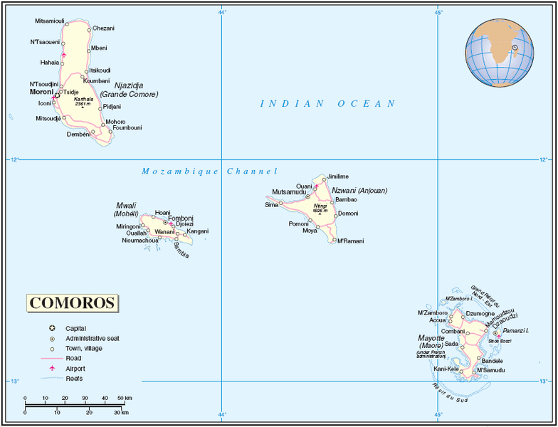
Ficheiro:Comoros Mayotte.PNG

Tamaño desta vista previa: 784 × 600 píxeles. Outras resolucións: 314 × 240 píxeles | 628 × 480 píxeles | 847 × 648 píxeles.
Ficheiro orixinal (847 × 648 píxeles; tamaño do ficheiro: 70 kB; tipo MIME: image/png)
Historial do ficheiro
Prema nunha data/hora para ver o ficheiro tal e como estaba nese momento.
| Data/Hora | Miniatura | Dimensións | Usuario | Comentario | |
|---|---|---|---|---|---|
| actual | 26 de xullo de 2005 ás 05:04 |  | 847 × 648 (70 kB) | Taichi | Map of Comoros and Mayotte Source: http://www.un.org/Depts/Cartographic/map/profile/comoros.pdf About the maps: The United Nations cartographics section claims: :''Unless otherwise noted, the maps included on this web site are produced by the Cartograph |
Uso do ficheiro
A seguinte páxina usa este ficheiro:
Uso global do ficheiro
Os seguintes wikis empregan esta imaxe:
- Uso en ar.wikipedia.org
- Uso en ast.wikipedia.org
- Uso en cbk-zam.wikipedia.org
- Uso en ceb.wikipedia.org
- Uso en eo.wikipedia.org
- Uso en es.wikipedia.org
- Uso en fi.wikipedia.org
- Uso en fr.wikipedia.org
- Uso en he.wikipedia.org
- Uso en lfn.wikipedia.org
- Uso en mg.wikipedia.org
- Uso en mt.wikipedia.org
- Uso en pt.wikipedia.org
- Uso en ro.wikipedia.org
- Uso en ru.wikipedia.org
- Uso en sv.wikipedia.org
- Uso en uk.wikipedia.org
- Uso en www.wikidata.org
- Uso en zh.wikipedia.org

