
Ficheiro:CallingCodesWorld-Labeled.svg

Tamaño desta vista previa en PNG do ficheiro en formato SVG: 800 × 411 píxeles. Outras resolucións: 320 × 164 píxeles | 640 × 329 píxeles | 1.024 × 526 píxeles | 1.280 × 657 píxeles | 2.560 × 1.314 píxeles.
Ficheiro orixinal (ficheiro SVG; resolución de 2.560 × 1.314 píxeles; tamaño do ficheiro: 1,06 MB)
| Este ficheiro procede de Wikimedia Commons. A continuación móstrase a información da súa páxina de descrición. Commons é un repositorio libre de ficheiros multimedia. Pode contribuír alí cargando as súas imaxes. |
Resumo
| Descrición |
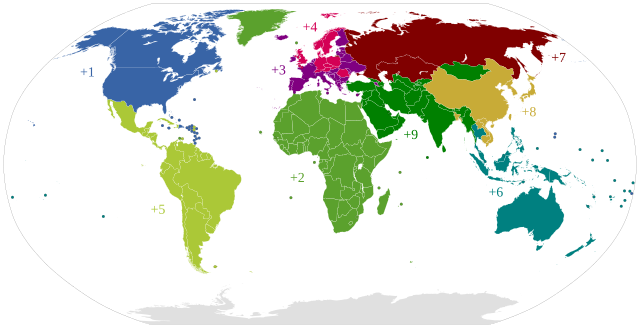
English: This world map shows the areas of the first digit of the country calling codes
Deutsch: Die Weltkarte stellt die Zonen der Ländervorwahlen dar
Français : Cette carte du monde montre les zones en fonction du premier digit des indicatifs de pays des numéros UIT-T E.164 internationaux
Italiano: Mappa mondiale dei prefissi telefonici internazionali (prima cifra)
|
||||
| Data | (UTC) | ||||
| Orixe | Created by adding text labels and applying styles to File:BlankMap-World6.svg | ||||
| Autoría | File:BlankMap-World6.svg: Canuckguy and many others / *obra derivada Anomie | ||||
| Licenza (Reuso deste ficheiro) |
Eu, como posuidor dos dereitos de autor desta obra, pola presente publícoa baixo a seguinte licenza:
|
||||
| SVG desenvolvimento | Esta imaxe vectorial foi creada co Other tools Esta carta geográfica SVG emprega texto encapsulado/cifras. |

Rexistro de cargas orixinal
This image is a derivative work of the following images:
- File:BlankMap-World6.svg licensed with PD-self
- 2011-08-27T00:51:14Z Anomie 863x443 (1612580 Bytes) South Sudan has been assigned code SS, so use that code.
- 2011-07-30T18:04:36Z Lokal Profil 863x443 (1612578 Bytes) Minor circle related changes and remove the legacy lpentagram
- 2011-07-08T23:26:24Z NuclearVacuum 863x443 (1613386 Bytes) South Sudan is free!! Hooray
- 2011-07-04T20:41:30Z NuclearVacuum 863x443 (1615589 Bytes) Restored to previous version, as SS isn't independent yet. But the code is now ready and waiting
- 2011-07-04T20:40:06Z NuclearVacuum 863x443 (1613386 Bytes) Separated South Sudan from (North) Sudan in preparation for SS independence on July 9, 2011.
- 2011-06-27T15:15:14Z Canuckguy 863x443 (1615589 Bytes) restored PR, set id labels for West Bank and Gaza
- 2011-04-01T14:09:57Z NuclearVacuum 863x443 (1614917 Bytes) Mayotte is now a department of France
- 2011-02-17T14:31:36Z NuclearVacuum 863x443 (1614903 Bytes) minor fixes
- 2011-02-13T01:43:20Z Canuckguy 863x443 (1632654 Bytes) minor fix
- 2011-01-22T20:16:24Z NuclearVacuum 863x443 (1614900 Bytes) added lakes
- 2011-01-22T20:12:02Z NuclearVacuum 863x443 (1632622 Bytes) ...
- 2011-01-22T20:08:04Z NuclearVacuum 863x443 (1632651 Bytes) Reverted to version as of 18:31, 17 January 2011
- 2011-01-22T20:07:39Z NuclearVacuum 1173x937 (334238 Bytes) just testing something
- 2011-01-17T18:31:33Z NuclearVacuum 863x443 (1632651 Bytes) minor fix of Sudan
- 2011-01-17T18:26:18Z NuclearVacuum 863x443 (1632651 Bytes) minor fix
- 2011-01-17T18:17:24Z NuclearVacuum 863x443 (1632633 Bytes) clean code
- 2011-01-17T18:12:07Z NuclearVacuum 863x443 (1632625 Bytes) added new class of circles, added Southern Sudan as a region within Sudan.
- 2011-01-15T00:06:15Z NuclearVacuum 863x443 (1631574 Bytes) minor fix
- 2011-01-14T23:51:44Z NuclearVacuum 863x443 (1631571 Bytes) added missing regions of the European Union
- 2011-01-13T14:26:50Z NuclearVacuum 863x443 (1631559 Bytes) minor fix
- 2011-01-13T14:17:57Z NuclearVacuum 863x443 (1631550 Bytes) added the BES Islands to the Netherladns
- 2011-01-07T21:02:08Z NuclearVacuum 863x443 (1631333 Bytes) minor fix
- 2011-01-07T20:55:32Z NuclearVacuum 863x443 (1631333 Bytes) corrected code for the circles
- 2011-01-06T16:44:29Z NuclearVacuum 863x443 (1208206 Bytes) removed all but 5px of whitespace, see talk page
- 2011-01-03T14:03:40Z NuclearVacuum 854x433 (1208195 Bytes) Curaçao and Sint Maarten have been given codes
- 2011-01-02T03:21:03Z Tomchen1989 854x433 (1205379 Bytes) compromised for the bug
- 2010-12-28T01:58:24Z Kintetsubuffalo 853x433 (1205378 Bytes) what are you talking about? nothing is cut off or squished
- 2010-12-28T00:28:42Z NuclearVacuum 940x477 (1631321 Bytes) Reverted to version as of 16:43, 27 October 2010
- 2010-12-19T20:10:58Z Tomchen1989 853x433 (1205378 Bytes) stroke-width of coast
- 2010-12-19T08:51:57Z Tomchen1989 853x433 (1205378 Bytes) minor change
- 2010-12-16T16:14:47Z Tomchen1989 853x433 (1205378 Bytes) radius of the circles changed
- 2010-12-14T22:57:20Z Tomchen1989 853x433 (1208461 Bytes) small fixed
- 2010-12-14T22:36:00Z Tomchen1989 853x433 (1208830 Bytes) had outside whitespace removed; cleaned the code; used tab indent
- 2010-10-27T16:43:23Z NuclearVacuum 940x477 (1631321 Bytes) fixed as part of discussion
- 2010-10-24T03:54:05Z NuclearVacuum 940x477 (1630960 Bytes) I fixed the code so it is valid
- 2010-10-10T22:06:16Z Canuckguy 940x477 (1630991 Bytes) Reverted to version as of 02:01, 18 September 2010 (Neth. Antilles removed, Sint Maarten and Curacao added, Bonaire part of "nl")
- 2010-09-18T02:01:50Z Canuckguy 940x477 (1630802 Bytes) Reverted to version as of 01:03, 9 July 2010. New version to be used October 10, 2010
- 2010-09-18T02:01:03Z Canuckguy 940x477 (1630991 Bytes) version with Sint Maarten and Curacao added, Bonaire as part of Netherlands, and Netherlands Antilles removed. To be used starting October 10, 2010
- 2010-07-09T01:03:28Z NuclearVacuum 940x477 (1630802 Bytes) after thinking about it, I think "aa" is better for the ocean than "zz"
- 2010-07-07T21:49:57Z NuclearVacuum 940x477 (1630805 Bytes) Reverted to version as of 20:25, 7 July 2010
- 2010-07-07T21:49:26Z NuclearVacuum 940x477 (1629207 Bytes) Reverted to version as of 16:45, 25 June 2010
- 2010-07-07T21:48:28Z NuclearVacuum 940x477 (1630623 Bytes) Reverted to version as of 16:51, 29 June 2010 checking
- 2010-07-07T21:47:19Z NuclearVacuum 940x477 (1630506 Bytes) Reverted to version as of 14:49, 1 July 2010 checking something
- 2010-07-07T20:25:43Z NuclearVacuum 940x477 (1630805 Bytes) added marker for Swaziland
- 2010-07-07T19:43:09Z NuclearVacuum 940x477 (1630656 Bytes) added the European Union
- 2010-07-01T14:49:16Z NuclearVacuum 940x477 (1630506 Bytes) minor mistake
- 2010-07-01T14:47:13Z NuclearVacuum 940x477 (1630506 Bytes) Created code for the French Southern and Antarctic Lands.
- 2010-06-29T16:51:08Z NuclearVacuum 940x477 (1630623 Bytes) minor code cleanup
- 2010-06-28T22:28:48Z NuclearVacuum 940x477 (1630576 Bytes) new version taking into account the unrecognized nations and using user-assigned code.
- 2010-06-28T20:16:10Z NuclearVacuum 940x477 (1630640 Bytes) added separate class for unrecognized nations, minor cleanup
Carregada com derivativeFX
Historial do ficheiro
Prema nunha data/hora para ver o ficheiro tal e como estaba nese momento.
| Data/Hora | Miniatura | Dimensións | Usuario | Comentario | |
|---|---|---|---|---|---|
| actual | 9 de xuño de 2019 ás 23:32 | | 2.560 × 1.314 (1,06 MB) | Fibonacci | Remade based on File:BlankMap-World.svg |
| 27 de agosto de 2011 ás 00:58 |  | 863 × 443 (1,54 MB) | Anomie | Corrected version based on latest BlankMap-World6.svg and en:List of country calling codes. Adds South Sudan (SS), BES Islands (BQ), Curaçao (CW), Sint Maarten (SX); removes Pitcairn (PN). | |
| 22 de agosto de 2011 ás 17:10 |  | 940 × 477 (1,6 MB) | Derfel73 | Added South Sudan | |
| 26 de agosto de 2010 ás 02:10 |  | 940 × 477 (1,56 MB) | Anomie | {{Information |Description={{en|1=This world map shows the areas of the first digit of the country calling codes }} {{de|1=Die Weltkarte stellt die Zonen der Ländervorwahlen dar}} ---- {{ValidSVG}} |Source=Created by adding text labels and applying style |
Uso do ficheiro
Non hai páxinas que usen este ficheiro.
Uso global do ficheiro
Os seguintes wikis empregan esta imaxe:
- Uso en id.wikipedia.org
- Uso en min.wikipedia.org
- Uso en www.wikidata.org