
Ficheiro:British Columbia-map.png
Non se pode ver nunha resolución meirande.
British_Columbia-map.png (280 × 230 píxeles; tamaño do ficheiro: 14 kB; tipo MIME: image/png)
| Este ficheiro procede de Wikimedia Commons. A continuación móstrase a información da súa páxina de descrición. Commons é un repositorio libre de ficheiros multimedia. Pode contribuír alí cargando as súas imaxes. |

|
File:British Columbia, Canada.svg é unha versión vectorial deste ficheiro. Debería usarse esa versión no canto desta imaxe rasterizada cando sexa de mellor calidade.
File:British Columbia-map.png → File:British Columbia, Canada.svg
Para obter máis información acerca de gráficos vectoriais, vaia á páxina sobre a transición a SVG en Commons. Tamén hai información sobre o soporte de MediaWiki de imaxes SVG. |
 |
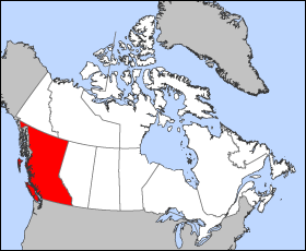
Map of British Columbia
Projection: Lambert azimuthal equal-area
Geospatial data from: The Atlas of Canada, The National Atlas of the United States archive copy at the Wayback Machine and U.S. Geological Survey
Cartographer: John Fowler
| Eu, como posuidor dos dereitos de autor desta obra, libéroa para que pertenza ao dominio público. Isto é válido en todo o mundo. Nalgúns países, isto pode non ser legalmente posible; entón: Concedo a calquera o dereito de empregar esta obra para o propósito que considere oportuno, sen condicións, agás aquelas que sexan requiridas pola lei. |
Historial do ficheiro
Prema nunha data/hora para ver o ficheiro tal e como estaba nese momento.
| Data/Hora | Miniatura | Dimensións | Usuario | Comentario | |
|---|---|---|---|---|---|
| actual | 24 de marzo de 2005 ás 12:12 | | 280 × 230 (14 kB) | Voyager | Map of British Columbia Projection: Lambert azimuthal equal-area Geospatial data from: [http://atlas.gc.ca/ The Atlas of Canada], [http://www.nationalatlas.gov/ The National Atlas of the United States] and [http://www.usgs.gov U.S. Geological Survey] C |
Uso do ficheiro
Non hai páxinas que usen este ficheiro.
Uso global do ficheiro
Os seguintes wikis empregan esta imaxe:
- Uso en fr.wikipedia.org
- Uso en he.wikivoyage.org