
Ficheiro:Waterpocket Fold - Looking south from the Strike Valley Overlook.jpg
Non se pode ver nunha resolución meirande.
Waterpocket_Fold_-_Looking_south_from_the_Strike_Valley_Overlook.jpg (800 × 600 píxeles; tamaño do ficheiro: 592 kB; tipo MIME: image/jpeg)
| Este ficheiro procede de Wikimedia Commons. A continuación móstrase a información da súa páxina de descrición. Commons é un repositorio libre de ficheiros multimedia. Pode contribuír alí cargando as súas imaxes. |
| Descrición |
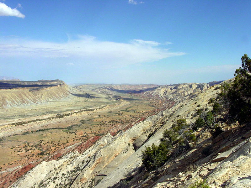
English: Perhaps the most amazing view in the region is this scene looking south from the Strike Valley Overlook along a great, warping arc in the greater Waterpocket Fold. The scene encompasses about a 2 kilometer thick section of sedimentary rocks and landscape features representing more than 200 million years of earth surface processes and conditions. The oldest sedimentary rocks on the right (the Navajo Sandstone) represents a great blanket of desert dunes that extended across the region at the close of Triassic time. Morrison Formation in the center represents the changes in Jurassic time when the great dune fields gave way to coastal floodplains, swamps, and shallow inland seas. The Mancos Shale represents the formation of a great inland Western Interior Seaway that lasted in the region through almost all of Cretaceous time. Finally this seaway withdrew at the close of Cretaceous time, the land rose, and volcanoes of the Henry Mountains formed in early Tertiary time (probably during the Oligocene Epoch between 37 and 24 million years ago). Since middle Tertiary time, the land has been steadily rising and eroding, perhaps at an increasing rate with the development of the modern Colorado River system across the region. |
|||
| Data | 8 de agosto de 2003 (segundo os datos Exif) | |||
| Orixe | USGS – 3dparks.wr.usgs.gov | |||
| Autoría | Descoñecido | |||
| Licenza (Reuso deste ficheiro) |
|
Historial do ficheiro
Prema nunha data/hora para ver o ficheiro tal e como estaba nese momento.
| Data/Hora | Miniatura | Dimensións | Usuario | Comentario | |
|---|---|---|---|---|---|
| actual | 16 de marzo de 2006 ás 03:05 | | 800 × 600 (592 kB) | Mav | USGS image from [http://3dparks.wr.usgs.gov/capitol2/html/3d4665.html] Perhaps the most amazing view in the region is this scene looking south from the Strike Valley Overlook along a great, warping arc in the greater Waterpocket Fold. The scene encompass |
Uso do ficheiro
A seguinte páxina usa este ficheiro:
Uso global do ficheiro
Os seguintes wikis empregan esta imaxe:
- Uso en ar.wikipedia.org
- Uso en bg.wikipedia.org
- Uso en en.wikipedia.org
- Uso en es.wikipedia.org
- Uso en fr.wikipedia.org
- Uso en ja.wikipedia.org
- Uso en lt.wikipedia.org
- Uso en tr.wikipedia.org