
Ficheiro:Volga.A2002137.0745.250m.jpg

Ficheiro orixinal (4.600 × 6.000 píxeles; tamaño do ficheiro: 3,91 MB; tipo MIME: image/jpeg)
| Este ficheiro procede de Wikimedia Commons. A continuación móstrase a información da súa páxina de descrición. Commons é un repositorio libre de ficheiros multimedia. Pode contribuír alí cargando as súas imaxes. |
http://visibleearth.nasa.gov/view_rec.php?id=3823
Credit: Jacques Descloitres, MODIS Land Rapid Response Team, NASA/GSFC
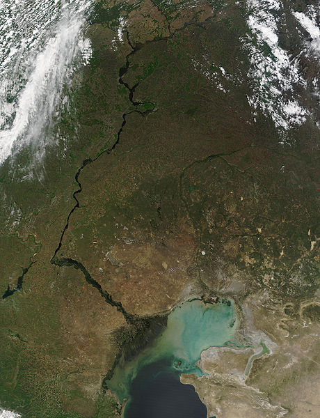
This MODIS image from May 17, 2002, shows the Volga River running north-south and emptying into the Caspian Sea. At lower left, extensive cultivation of the land can be seen in the regular patterns of fields. The light-colored waters of the Caspian Sea may be due to high sediment in the rivers that flow into it, as well as pollution and aquatic plant growth.
Metadata
- Sensor: Terra/MODIS
- Datastart: 2002-05-17
- Dataend: 2002-05-17
- Visible Earth v1 ID 19787
- Visualization Date: 2002-05-24
1. All Sensors 2. » MODIS
| Este ficheiro está no dominio público porque foi creado pola NASA. A política do copyright da NASA declara que "o material da NASA non está protexido polos dereitos de autor a non ser que se indique o contrario". (Páxina de políticas do copyright da NASA ou política de uso de imaxes JPL). | ||
 |
Avisos:
|
Historial do ficheiro
Prema nunha data/hora para ver o ficheiro tal e como estaba nese momento.
| Data/Hora | Miniatura | Dimensións | Usuario | Comentario | |
|---|---|---|---|---|---|
| actual | 25 de agosto de 2005 ás 21:38 | | 4.600 × 6.000 (3,91 MB) | Nanosmile | http://visibleearth.nasa.gov/view_rec.php?id=3823 Credit: Jacques Descloitres, MODIS Land Rapid Response Team, NASA/GSFC This MODIS image from May 17, 2002, shows the Volga River running north-south and emptying into the Caspian Sea. At lower left, exte |
Uso do ficheiro
A seguinte páxina usa este ficheiro:
Uso global do ficheiro
Os seguintes wikis empregan esta imaxe:
- Uso en ar.wikipedia.org
- Uso en as.wikipedia.org
- Uso en av.wikipedia.org
- Uso en bg.wikipedia.org
- Uso en bh.wikipedia.org
- Uso en bn.wikipedia.org
- Uso en ca.wikipedia.org
- Uso en cv.wikipedia.org
- Uso en cy.wikipedia.org
- Uso en el.wikipedia.org
- Uso en en.wikipedia.org
- Uso en es.wikipedia.org
- Uso en it.wikipedia.org
- Uso en lad.wikipedia.org
- Uso en no.wikipedia.org
- Uso en pa.wikipedia.org
- Uso en pnb.wikipedia.org
- Uso en ro.wikipedia.org
- Uso en sl.wikipedia.org
- Uso en tl.wikipedia.org
- Uso en tr.wikipedia.org
- Uso en uk.wikipedia.org
- Uso en ur.wikipedia.org