
Ficheiro:Spielberg bare map numbers simplified.svg

Tamaño desta vista previa en PNG do ficheiro en formato SVG: 742 × 600 píxeles. Outras resolucións: 297 × 240 píxeles | 594 × 480 píxeles | 950 × 768 píxeles | 1.267 × 1.024 píxeles | 2.533 × 2.048 píxeles | 2.419 × 1.956 píxeles.
Ficheiro orixinal (ficheiro SVG; resolución de 2.419 × 1.956 píxeles; tamaño do ficheiro: 134 kB)
| Este ficheiro procede de Wikimedia Commons. A continuación móstrase a información da súa páxina de descrición. Commons é un repositorio libre de ficheiros multimedia. Pode contribuír alí cargando as súas imaxes. |
Resumo
| Descrición |
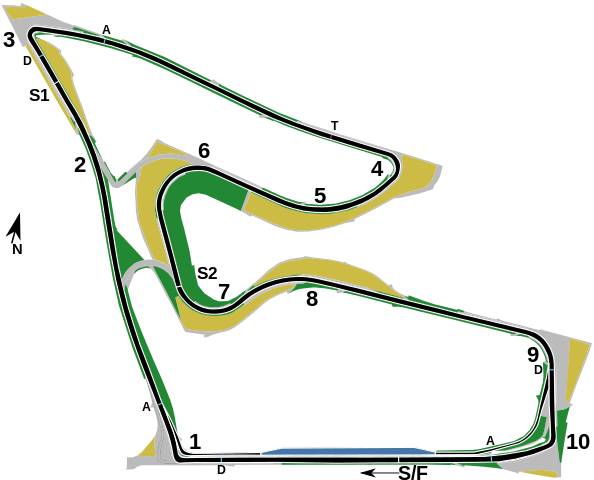
English: This is a map of the w:en:Red Bull Ring, formerly known as the A1-Ring and the Österreichring, in w:en:Spielberg, Austria. It shows the circuit roughly as it has been in the period spanning 2014-2021. Corner numbers are marked with the numbers "1" through "10", the start/finish line is marked as "S/F" with an arrow showing a direction of travel. The marker "S1" shows the end of the first sector, and the marker "S2" shows the end of the second sector. The markers labelled "D" show the w:en:Drag Reduction System detection points for w:en:Formula One, while the markers labelled "A" shows the activation points. The marker labelled "T" shows the speed trap used in Formula One. The location of these markers was sourced from the FIA's official Formula One circuit map. The arrow marked "N" shows the direction of north. The track layout and pit lane entrance and exit are shown in black with a white outline, while the pit lane itself is shown in blue. Green areas mark grass run-off areas, grey areas mark paved run-off areas, and yellow areas mark gravel traps. |
| Data | |
| Orixe | Planet Labs, image also available on Wikimedia Commons |
| Autoría | I, User:HumanBodyPiloter5, created this SVG map as a derivative work based on the satellite image of the Spielberg circuit released by w:en:Planet Labs under CC-BY-SA 4.0 in 2018 |
Licenza
Este ficheiro está licenciado baixo a licenza Creative Commons recoñecemento compartir igual 4.0 internacional.
- Vostede é libre de:
- compartir – copiar, distribuír e difundir a obra
- facer obras derivadas – adaptar a obra
- Baixo as seguintes condicións:
- recoñecemento – Debe indicar a debida atribución de autoría, fornecer unha ligazón á licenza e indicar se se realizaron cambios. Pode facer isto de calquera forma razoable, mais non nunha forma que indique que quen posúe a licenza apoia ou subscribe o seu uso da obra.
- compartir igual – Se altera, transforma ou amplía este contido, debe publicar as súas contribucións baixo a mesma licenza ou outra compatible á orixinal.
Historial do ficheiro
Prema nunha data/hora para ver o ficheiro tal e como estaba nese momento.
| Data/Hora | Miniatura | Dimensións | Usuario | Comentario | |
|---|---|---|---|---|---|
| actual | 26 de xuño de 2021 ás 19:57 | | 2.419 × 1.956 (134 kB) | HumanBodyPiloter5 | Uploaded a work by I, User:HumanBodyPiloter5, created this SVG map as a derivative work based on the satellite image of the Spielberg circuit released by Planet Labs under CC-BY-SA 4.0 in 2018 from [https://medium.com/planet-stories/a-grand-prix-world-tour-86b08d45ae46 Planet Labs], image also available [https://commons.wikimedia.org/wiki/File:Red_Bull_Ring,_April_18,_2018_SkySat.jpg on Wikimedia Commons] with UploadWizard |
Uso do ficheiro
A seguinte páxina usa este ficheiro:
Uso global do ficheiro
Os seguintes wikis empregan esta imaxe:
- Uso en cs.wikipedia.org
- Uso en en.wikipedia.org