
Ficheiro:South Africa 2011 population density map.svg

Tamaño desta vista previa en PNG do ficheiro en formato SVG: 684 × 599 píxeles. Outras resolucións: 274 × 240 píxeles | 548 × 480 píxeles | 876 × 768 píxeles | 1.168 × 1.024 píxeles | 2.337 × 2.048 píxeles | 809 × 709 píxeles.
Ficheiro orixinal (ficheiro SVG; resolución de 809 × 709 píxeles; tamaño do ficheiro: 1,93 MB)
| Este ficheiro procede de Wikimedia Commons. A continuación móstrase a información da súa páxina de descrición. Commons é un repositorio libre de ficheiros multimedia. Pode contribuír alí cargando as súas imaxes. |
Resumo
| Descrición |
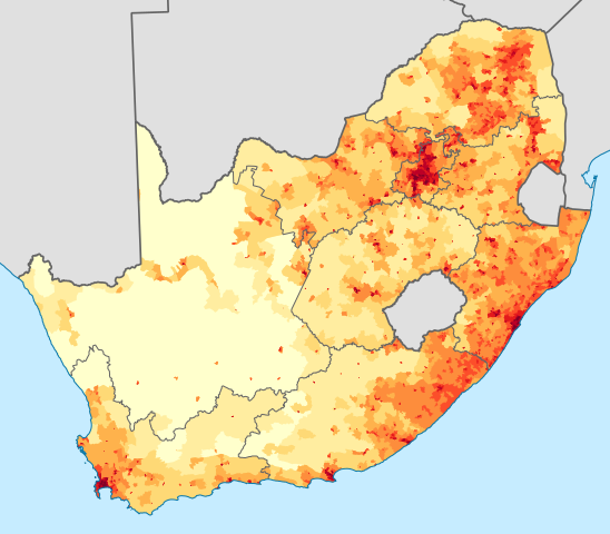
English: Population density map of South Africa, based on the 2011 census using ward-level data.
<1 inhabitant/km²
1–3 inhabitants/km²
3–10 inhabitants/km²
10–30 inhabitants/km²
30–100 inhabitants/km²
100–300 inhabitants/km²
300–1000 inhabitants/km²
1000–3000 inhabitants/km²
>3000 inhabitants/km²
Projection is Albers Equal-Area Conic, with standard parallels at 25.5° S and 31.5° S, and origin at 28.5° S 24.5° E.Deutsch: Bevölkerungsdichte Südafrikas im Jahr 2011:
<1 Einwohner/km²
1–3 Einwohner/km²
3–10 Einwohner/km²
10–30 Einwohner/km²
30–100 Einwohner/km²
100–300 Einwohner/km²
300–1000 Einwohner/km²
1000–3000 Einwohner/km²
>3000 Einwohner/km² |
| Data | |
| Orixe | Statistics South Africa's Census 2011 is the source of the basic population data. The map results from my own processing of the data. For ward boundaries see File:South Africa electoral wards 2011 blank.svg. |
| Autoría | Htonl |
| Outras versións |
South Africa 2011 population density map (hex cells).svg: .svg) |
Licenza
The following license applies to the population data on which the map is based:

|
O propietario dos dereitos de autor deste ficheiro, Stats SA, permite que calquera poida usalo para calquera propósito, sempre e cando se lle recoñeza a autoría a quen cede os dereitos. A redistribución, edición, uso comercial e calquera outro tipo de uso están permitidos. |
Recoñecemento:
"the user acknowledges Stats SA as the source of the basic data wherever they process, apply, utilise, publish or distribute the data, and also that they specify that the relevant application and analysis (where applicable) result from their own processing of the data" [1]
|
The following tag applies to the map itself:
| Eu, como posuidor dos dereitos de autor desta obra, libéroa para que pertenza ao dominio público. Isto é válido en todo o mundo. Nalgúns países, isto pode non ser legalmente posible; entón: Concedo a calquera o dereito de empregar esta obra para o propósito que considere oportuno, sen condicións, agás aquelas que sexan requiridas pola lei. |
Historial do ficheiro
Prema nunha data/hora para ver o ficheiro tal e como estaba nese momento.
| Data/Hora | Miniatura | Dimensións | Usuario | Comentario | |
|---|---|---|---|---|---|
| actual | 14 de novembro de 2012 ás 23:36 | | 809 × 709 (1,93 MB) | Htonl | fix KZN coast error |
| 14 de novembro de 2012 ás 21:57 |  | 809 × 709 (1,93 MB) | Htonl | == {{int:filedesc}} == {{Information |Description={{en|1=Population density map of South Africa, based on the 2011 census using ward-level data. {{legend|#ffffcc|<1 inhabitant/km²}} {{legend|#ffeda0|1–3 inhabitants/km²}} {{legend|#fed976|3–10 ... |
Uso do ficheiro
A seguinte páxina usa este ficheiro:
Uso global do ficheiro
Os seguintes wikis empregan esta imaxe:
- Uso en af.wikipedia.org
- Uso en azb.wikipedia.org
- Uso en az.wikipedia.org
- Uso en ca.wikipedia.org
- Uso en cs.wikipedia.org
- Uso en de.wikipedia.org
- Uso en el.wikipedia.org
- Uso en en.wikipedia.org
- Uso en es.wikipedia.org
- Uso en et.wikipedia.org
- Uso en fr.wikipedia.org
- Uso en he.wikipedia.org
- Uso en hu.wikipedia.org
- Uso en hy.wikipedia.org
- Uso en ja.wikipedia.org
- Uso en ka.wikipedia.org
- Uso en ko.wikipedia.org
- Uso en la.wikipedia.org
- Uso en lt.wikipedia.org
- Uso en ml.wikipedia.org
- Uso en nl.wikipedia.org
- Uso en no.wikipedia.org
- Uso en pt.wikipedia.org
- Uso en ro.wikipedia.org
- Uso en ru.wikipedia.org
- Uso en sr.wikipedia.org
- Uso en sv.wikipedia.org
- Uso en te.wikipedia.org
- Uso en tg.wikipedia.org
- Uso en tr.wikipedia.org
- Uso en uk.wikipedia.org
- Uso en zh.wikipedia.org