
Ficheiro:Sakha Republic - administrative divisions numbered.svg

Tamaño desta vista previa en PNG do ficheiro en formato SVG: 598 × 600 píxeles. Outras resolucións: 239 × 240 píxeles | 479 × 480 píxeles | 766 × 768 píxeles | 1.021 × 1.024 píxeles | 2.042 × 2.048 píxeles | 702 × 704 píxeles.
Ficheiro orixinal (ficheiro SVG; resolución de 702 × 704 píxeles; tamaño do ficheiro: 119 kB)
| Este ficheiro procede de Wikimedia Commons. A continuación móstrase a información da súa páxina de descrición. Commons é un repositorio libre de ficheiros multimedia. Pode contribuír alí cargando as súas imaxes. |
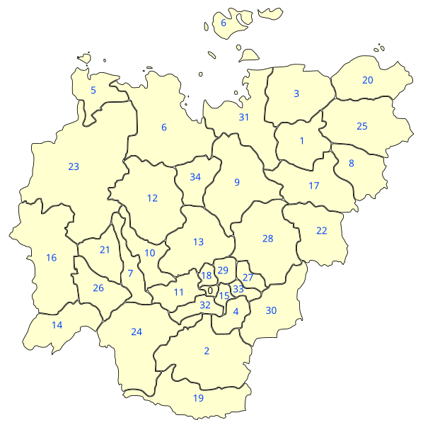
| Descrición | Map of the uluses of Sakha Republic. Non-contiguous parts of uluses have been grouped together and each ulus (and New Siberian Islands) has been id-tagged with it's name. |
| Data | (UTC) |
| Orixe | |
| Autoría |
|
| Esta é unha imaxe retocada,en o que significa que a súa versión orixinal foi alterada dixitalmente. Modificacións: numbered version (see ru:Файл:Sakha_Republic_Municipal_Divisions.PNG. A orixinal pódese ver aquí: Sakha Republic - administrative divisions.svg. As modificacións realizounas Katpatuka.
|
Eu, como posuidor dos dereitos de autor desta obra, pola presente publícoa baixo a seguinte licenza:
Este ficheiro está licenciado baixo a licenza Creative Commons recoñecemento compartir igual xenérico 2.5.
- Vostede é libre de:
- compartir – copiar, distribuír e difundir a obra
- facer obras derivadas – adaptar a obra
- Baixo as seguintes condicións:
- recoñecemento – Debe indicar a debida atribución de autoría, fornecer unha ligazón á licenza e indicar se se realizaron cambios. Pode facer isto de calquera forma razoable, mais non nunha forma que indique que quen posúe a licenza apoia ou subscribe o seu uso da obra.
- compartir igual – Se altera, transforma ou amplía este contido, debe publicar as súas contribucións baixo a mesma licenza ou outra compatible á orixinal.
Rexistro de cargas orixinal
This image is a derivative work of the following images:
- File:Sakha_Republic_-_administrative_divisions.svg licensed with Cc-by-sa-2.5
- 2008-04-16T18:26:55Z Lokal Profil 702x704 (111541 Bytes) {{Information |Description=Map of the uluses of Sakha Republic. The [[:en:New Siberian Islands]] have a different coulour to indicate that they are not part of any ulus instead it is a natural reserve zone directly under juri
Carregada com derivativeFX
Historial do ficheiro
Prema nunha data/hora para ver o ficheiro tal e como estaba nese momento.
| Data/Hora | Miniatura | Dimensións | Usuario | Comentario | |
|---|---|---|---|---|---|
| actual | 4 de agosto de 2009 ás 15:57 | | 702 × 704 (119 kB) | Katpatuka | {{Information |Description=Map of the uluses of Sakha Republic. Non-contiguous parts of uluses have been grouped together and each ulus (and New Siberian Islands) has been id-tagged with it's name. |Source=*[[:File:Sakha_Republic_-_administrative_division |
Uso do ficheiro
A seguinte páxina usa este ficheiro:
Uso global do ficheiro
Os seguintes wikis empregan esta imaxe:
- Uso en fr.wikipedia.org
- Uso en nl.wikipedia.org