
Ficheiro:Ruínas do Castelo de Moura - Portugal (8235886036).jpg
Ficheiro orixinal (5.699 × 3.800 píxeles; tamaño do ficheiro: 4,84 MB; tipo MIME: image/jpeg)
| Este ficheiro procede de Wikimedia Commons. A continuación móstrase a información da súa páxina de descrición. Commons é un repositorio libre de ficheiros multimedia. Pode contribuír alí cargando as súas imaxes. |
.jpg)
Resumo
| Descrición |
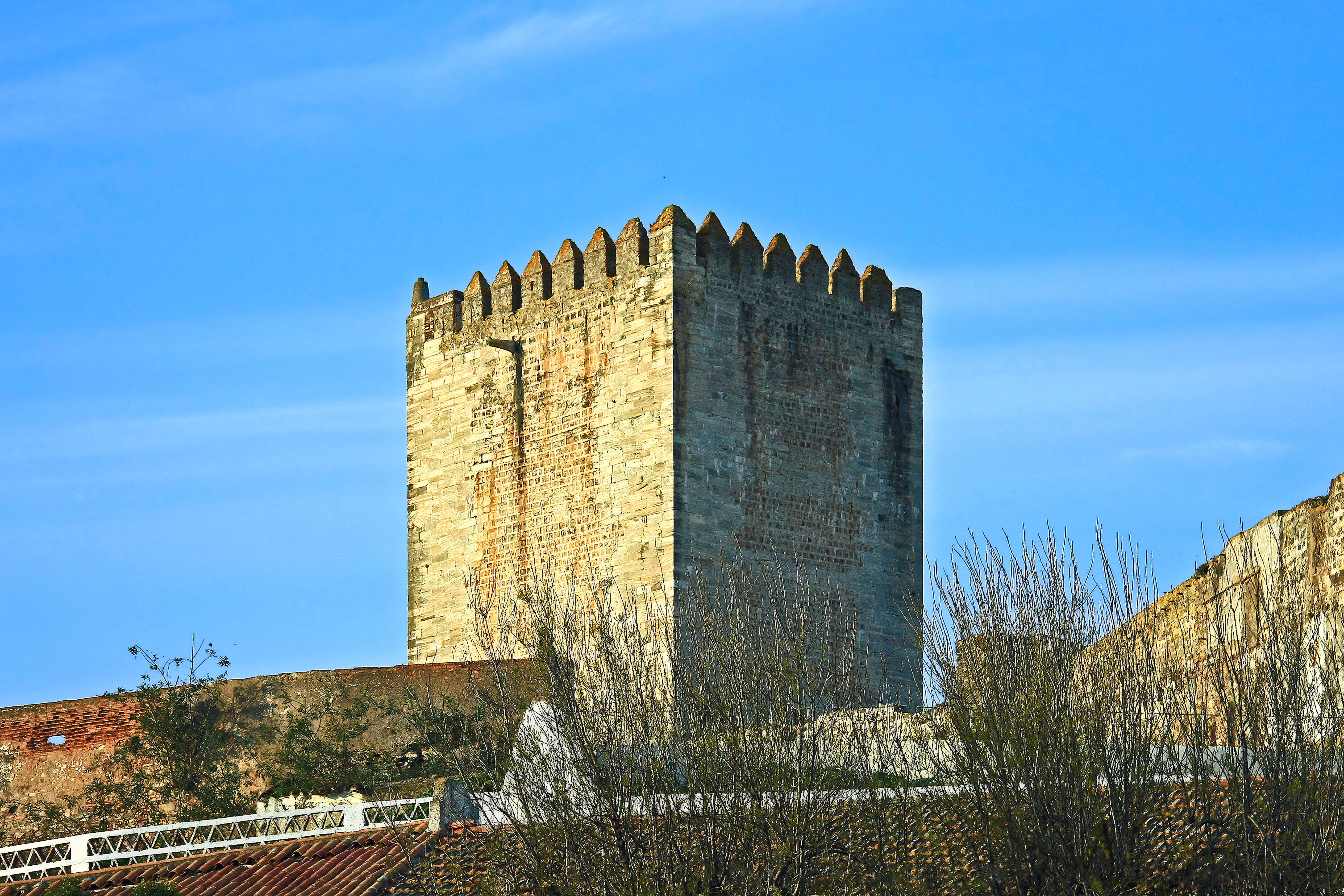
Dominando a cidade com o que resta das suas torres e muralhas, o castelo de Moura foi construído pelos portugueses no início do séc. XIV aproveitando as fortificações deixadas pelos árabes. Na segunda metade deste século foi-lhe acrescentada uma segunda cerca muralhada para abrigar a população que aumentava. No séc. XVI, D. Manuel I encarregou o arquitecto Francisco de Arruda de proceder a algumas alterações, em que se incluem provavelmente a torre do relógio, datando também desta época o convento feminino de S. Domingos, que se encontra no interior da cerca, mandado erguer por D. Ângela de Moura, em 1562, sobre as fundações da antiga mesquita. A igreja conventual guarda o túmulo manuelino dos irmãos Pedro e Álvaro Rodrigues, presumíveis conquistadores de Moura. Durante as Guerras da Restauração, na segunda metade do séc. XVII, a fortaleza medieval foi reforçada com uma linha de baluartes e revelins, segundo o projecto de Nicolau de Langres, adaptada às novas técnicas de guerra com armas de fogo. Do conjunto fortificado destacam-se a torre de menagem rectangular e uma torre circular sobre a qual se acrescentou um relógio no séc. XIX. <a href="http://www.visitportugal.com/NR/exeres/91EAFB7A-5E0E-4276-BD24-976024EAE784,frameless.htm" rel="nofollow">www.visitportugal.com/NR/exeres/91EAFB7A-5E0E-4276-BD24-9...</a> Dominating the town with what remains of its towers and walls, Moura castle was built by the Portuguese at the beginning of the 14th century, taking advantage of the fortifications left behind by the Arabs. In the second half of this same century, a second walled enclosure was added to provide shelter for the growing population. In the 16th century, D. Manuel I commissioned Francisco de Arruda to make some alterations, which probably included the clock tower. Also dating from this time was the convent of São Domingos, built within the walled enclosure at the orders of D. Ângela de Moura, in 1562, upon the foundations of the former mosque. The convent church contains the Manueline tomb of the brothers Pedro and Álvaro Rodrigues, the presumed conquerors of Moura. During the Wars of Restoration of Portugal from Spain, in the second half of the 17th century, the mediaeval fortress was strengthened with a line of bulwarks and ravelins, in keeping with the project developed by Nicolau de Langres, and adapted to withstand the new fighting techniques involving the use of firearms. Amongst the various fortifications, the most prominent feature is the sturdy-looking rectangular keep and a circular tower onto which a clock was added in the 19th century. <a href="http://www.visitportugal.com/NR/exeres/91EAFB7A-5E0E-4276-BD24-976024EAE784,frameless.htm" rel="nofollow">www.visitportugal.com/NR/exeres/91EAFB7A-5E0E-4276-BD24-9...</a> <a href="http://loc.alize.us/#/flickr:8235886036" rel="nofollow">See where this picture was taken.</a> <a href="https://www.flickr.com/groups/geotagging/discuss/72157594165549916/">[?]</a> |
| Data | |
| Orixe | Ruínas do Castelo de Moura - Portugal |
| Autoría | Vitor Oliveira from Torres Vedras, PORTUGAL |
| Localización da cámara | | Esta e outras imaxes na súa localización en: OpenStreetMap |
|---|
.jpg¶ms=038.142960_N_-007.451491_E_globe:Earth_type:camera_source:Flickr_&language=gl)
Licenza
- Vostede é libre de:
- compartir – copiar, distribuír e difundir a obra
- facer obras derivadas – adaptar a obra
- Baixo as seguintes condicións:
- recoñecemento – Debe indicar a debida atribución de autoría, fornecer unha ligazón á licenza e indicar se se realizaron cambios. Pode facer isto de calquera forma razoable, mais non nunha forma que indique que quen posúe a licenza apoia ou subscribe o seu uso da obra.
- compartir igual – Se altera, transforma ou amplía este contido, debe publicar as súas contribucións baixo a mesma licenza ou outra compatible á orixinal.
| Esta imaxe foi publicada no Flickr por Portuguese_eyes en https://flickr.com/photos/21446942@N00/8235886036. A imaxe foi revisada o 15 de abril de 2019 polo robot FlickreviewR 2 e confirmou ter licenza baixo os termos de cc-by-sa-2.0. |
Historial do ficheiro
Prema nunha data/hora para ver o ficheiro tal e como estaba nese momento.
| Data/Hora | Miniatura | Dimensións | Usuario | Comentario | |
|---|---|---|---|---|---|
| actual | 15 de abril de 2019 ás 04:52 | | 5.699 × 3.800 (4,84 MB) | Tm | Transferred from Flickr via #flickr2commons |
Uso do ficheiro
A seguinte páxina usa este ficheiro:
Uso global do ficheiro
Os seguintes wikis empregan esta imaxe:
- Uso en en.wikipedia.org
- Uso en es.wikipedia.org
- Uso en pt.wikipedia.org
- Uso en www.wikidata.org
.jpg)