
Ficheiro:Physical Political World Map.jpg

Ficheiro orixinal (6.480 × 3.888 píxeles; tamaño do ficheiro: 5,69 MB; tipo MIME: image/jpeg)
| Este ficheiro procede de Wikimedia Commons. A continuación móstrase a información da súa páxina de descrición. Commons é un repositorio libre de ficheiros multimedia. Pode contribuír alí cargando as súas imaxes. |
| Descrición |
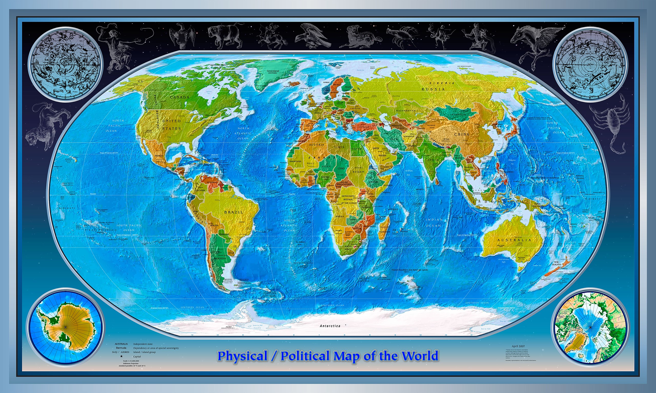
English: This is a composite of several images collected from the websites of the CIA and NASA.
Physical World Map 2007-04-01 CIA World Factbook; Robinson Projection; standard parallels 38°N and 38°S Subject: Physical map of the World, April, 2007 Projection: Robinson projection, Standard parallels, 38°N, 38°S Source: CIA World Factbook found at: https://www.cia.gov/library/publications/the-world-factbook/reference_maps/pdf/physical_world.pdf Political World Map 2007-04-01 CIA World Factbook; Robinson Projection; standard parallels 38°N and 38°S Subject: Political map of the World, April, 2007 Projection: Robinson projection, Standard parallels, 38°N, 38°S Source: CIA World Factbook found at: https://www.cia.gov/library/publications/the-world-factbook/reference_maps/pdf/political_world.pdf This image is in the public domain because it contains materials that originally came from the United States Central Intelligence Agency's World Factbook. Constellations (Hubblesource.stsci.edu) and Stary Field Background (Hubblesite.org) are public domain images from NASA.org http://hubblesource.stsci.edu/sources/illustrations/constellations/ http://hubblesite.org/gallery/album/ External links |
| Orixe | |
| Autoría |
Licenza
Esta imaxe atópase no dominio público, xa que o seu contido provén do World Factbook, unha publicación da Axencia Central de Intelixencia (CIA) dos Estados Unidos da América.
|
 |
Rexistro de cargas orixinal
- 2007-10-22 02:51 IMtheEyeInTheSky 6480×3888×??? (5961164 bytes) This is a composite of several images collected from the websites of the CIA and NASA. Physical World Map 2007-04-01 CIA World Factbook; Robinson Projection; standard parallels 38°N and 38°S Subject: Physical map of the World, April, 2007 Projection: R
Historial do ficheiro
Prema nunha data/hora para ver o ficheiro tal e como estaba nese momento.
| Data/Hora | Miniatura | Dimensións | Usuario | Comentario | |
|---|---|---|---|---|---|
| actual | 19 de setembro de 2008 ás 12:31 | | 6.480 × 3.888 (5,69 MB) | Nk | {{Information |Description={{en|This is a composite of several images collected from the websites of the CIA and NASA. Physical World Map 2007-04-01 CIA World Factbook; Robinson Projection; standard parallels 38°N and 38°S Subject: Physical map of the |
Uso do ficheiro
A seguinte páxina usa este ficheiro:
Uso global do ficheiro
Os seguintes wikis empregan esta imaxe:
- Uso en bg.wikipedia.org
- Uso en en.wikipedia.org