
Ficheiro:Old map 1807 plan.jpg
Ficheiro orixinal (1.004 × 1.192 píxeles; tamaño do ficheiro: 519 kB; tipo MIME: image/jpeg)
| Este ficheiro procede de Wikimedia Commons. A continuación móstrase a información da súa páxina de descrición. Commons é un repositorio libre de ficheiros multimedia. Pode contribuír alí cargando as súas imaxes. |
Resumo
| Descrición |
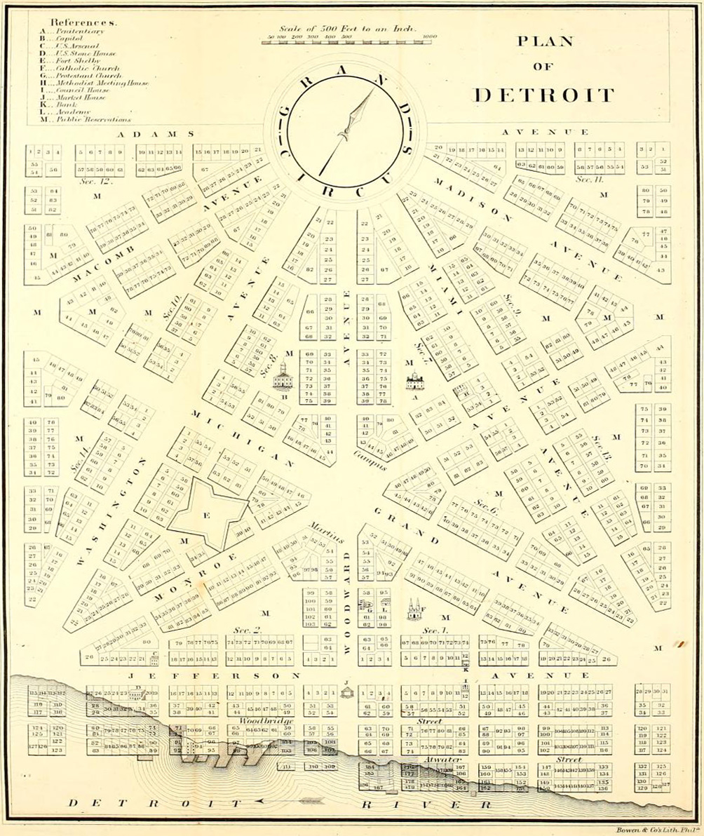
English: Detroit city layout plan circa 1807—following the 1805 fire that destroyed most of the city. The map shows Grand Circus Park (top), and some of the present-day Grand Circus Park Historic District. |
| Data | entre 1807 |
| Orixe | Dickens, Asbury & Forney, John W., eds. (1832) "Plan of Detroit" (Map). American State Papers. Vol. 6: Public Lands. 1:6,000. Washington, DC: Gales & Seaton. p. 299. OCLC 2053058. OL7014594M. LCCN 09033892. – via Archive.org. |
| Autoría | Descoñecido |
Licenza
Esta imaxe está no dominio público xa que é unha copia escaneada ou fotocopia dun orixinal no dominio público ou, segundo as probas dispoñibles, é tan semellante a dita copia ou fotocopia que non se pode esperar que xurda ningunha protección dos dereitos de autor. O orixinal en si mesmo atópase no dominio público polo seguinte motivo:
Esta etiqueta está deseñada para o seu uso cando pode existir a necesidade de asegurar que calquera mellora (por exemplo cambios no brillo, contraste, cores etc.) non é en si mesma o suficientemente creativa para xerar novos dereitos de autor. Pode empregarse cando se descoñeza se calquera mellora xa tivo lugar, así como cando as melloras sexan claras pero insuficientes. Para as copias escaneadas sen modificacións coñecidas pode usar o marcador axeitado {{PD-old}} no lugar deste. Para instrucións de uso vexa: Commons:When to use the PD-scan tag.  |


Historial do ficheiro
Prema nunha data/hora para ver o ficheiro tal e como estaba nese momento.
| Data/Hora | Miniatura | Dimensións | Usuario | Comentario | |
|---|---|---|---|---|---|
| actual | 4 de abril de 2013 ás 05:18 | | 1.004 × 1.192 (519 kB) | Imzadi1979 | perspective correction and cropped to remove whitespace |
| 22 de setembro de 2012 ás 16:46 |  | 1.115 × 1.348 (260 kB) | Imzadi1979 | higher resolution version with known source information | |
| 8 de xullo de 2007 ás 14:54 |  | 655 × 937 (146 kB) | DeltaWeb~commonswiki | == Summary == Detroit city layout circa 1807 following the 1805 fire that destroyed most of the city. From the Detroit Historical Museum site == Licensing == {{PD-US}} Category:Michigan maps Category:Images of Detroit, Michigan [[Category:Images |
Uso do ficheiro
As seguintes 2 páxinas usan este ficheiro:
Uso global do ficheiro
Os seguintes wikis empregan esta imaxe:
- Uso en ar.wikipedia.org
- Uso en en.wikipedia.org
- M-1 (Michigan highway)
- Campus Martius Park
- History of Detroit
- Augustus B. Woodward
- Grand Circus Park Historic District
- Gabriel Richard
- Washington Boulevard Historic District
- Roads and freeways in metropolitan Detroit
- National Register of Historic Places listings in Detroit
- Transportation in metropolitan Detroit
- User:Andrew Jameson/Detroit2
- User:Andrew Jameson/Detroit1
- National Register of Historic Places listings in Downtown and Midtown Detroit
- Great Fire of 1805
- Uso en es.wikipedia.org
- Uso en fa.wikipedia.org
- Uso en fr.wikipedia.org
- Uso en ru.wikipedia.org