Ficheiro:Ocean drainage.png
Os contidos da páxina non están dispoñibles noutras linguas.
Na Galipedia, a Wikipedia en galego.

Ficheiro orixinal(1.256 × 656 píxeles; tamaño do ficheiro: 75 kB; tipo MIME: image/png)

Resumo

Esta imaxe (ou todas as imaxes deste artigo ou categoría) deberían volverse crear como imaxes vectoriais SVG. Isto proporciona moitas vantaxes, véxase Commons:Media for cleanup (en inglés) para máis información. Se xa hai unha versión SVG desta imaxe dispoñible, por favor, cárguea en Commons. Tras subila, substitúa este modelo polo modelo {{vector version available|novo nome da imaxe.svg}} nesta imaxe.
Descrición
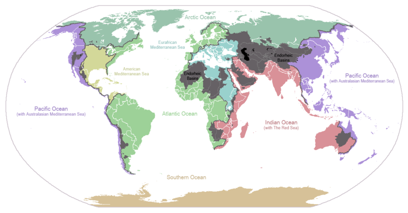
English: I made this map and hereby release it into the public domain. It shows the drainage basins for the major oceans and seas; grey areas are endorheic basins that do not drain to the ocean. Data is from the USGS Hydro1k project; information for Saskatchewan corrected by information from the Commission for Environmental Cooperation -- Citynoise
Description in large font size is used for oceans, in smaller font size is used for mediterranean seas. Only these mediterranean seas are listed which correspond to the definition of german Geographer Ernst Neef: A mediterranean sea is a sea between two Continents. Also found here: de:Mittelmeer --W like wiki (talk) 00:55, 12 March 2011 (UTC)
Français : Carte du monde des bassins versants. Les zones de couleur anthracite représentent les bassins endoréiques, qui ne sont reliés à aucun océan.
Čeština: Úmoří světových oceánů, popř. významných moří či zálivů. Legenda úmoří: fialová - Tichý oceán, růžová - Indický oceán, zelená - Atlantický oceán, azurová - Severní ledový oceán, béžová - Jižní oceán, modrá - Mexický záliv, světle modrá - Středozemní moře, šedá - oblast neústící ve světovém oceánu
Data 24 de xaneiro de 2007 (data de subida orixinal)
Orixe Transferido de en.wikipedia a Wikimedia Commons.
Autoría Citynoise em Wikipedia em inglés
Outras versións File:Major endorheic basins.png

Licenza

Public domain O autor desta obra, Citynoise em Wikipedia em inglés, liberouna e agora pertence ao dominio público. Isto é válido en todo o mundo.
Nalgúns países, isto pode non ser legalmente posible; entón:
Citynoise concede a calquera o dereito de empregar esta obra para o propósito que considere oportuno, sen condicións, agás aquelas que sexan requiridas pola lei.

Rexistro de cargas orixinal

A páxina orixinal de descrición está aquí. Tódolos seguintes nomes de usuario refírense a en.wikipedia.
  • 2007-05-20 17:59 Bolonium 1256×656×8 (50194 bytes) I made this map and hereby release it into the public domain. It shows the drainage basins for the major oceans and seas; grey areas are endorheic basins that do not drain to the ocean. -- [[User:Citynoise|Citynoise]] == Licensing == {{self
  • 2007-01-24 07:21 Citynoise 1256×656×8 (63359 bytes) I made this map and hereby release it into the public domain. It shows the drainage basins for the major oceans and seas; grey areas are endorheic basins that do not drain to the ocean.
  • 2007-01-24 06:09 Citynoise 1256×656×8 (57358 bytes) I made this map and hereby release it into the public domain. It shows the drainage basins for the major oceans and seas; grey areas are endorheic basins that do not drain to the ocean.
  • 2007-01-24 05:10 Citynoise 1256×656×8 (56360 bytes) I made this map and hereby release it into the public domain. It shows the drainage basins for the major oceans and seas; grey areas are endorheic basins that do not drain to the ocean.
  • 2007-01-24 04:55 Citynoise 1256×656×8 (56373 bytes) I made this map and hereby release it into the public domain. It shows the drainage basins for the major oceans and seas; grey areas are endorheic basins that do not drain to the ocean.

Pés de foto

Engada unha explicación dunha liña do representa este ficheiro
Drainage basins of the world, colored by ocean outlet. Endorheic basins not draining to an ocean are colored dark gray. Continental divides are indicated by dark lines.

Elementos retratados neste ficheiro

representa a

Historial do ficheiro

Prema nunha data/hora para ver o ficheiro tal e como estaba nese momento.

Data/HoraMiniaturaDimensiónsUsuarioComentario
actual6 de outubro de 2015 ás 23:25Miniatura da versión ás 23:25 do 6 de outubro de 20151.256 × 656 (75 kB)AcidSnowFixed Somalia.
12 de marzo de 2011 ás 00:39Miniatura da versión ás 00:39 do 12 de marzo de 20111.256 × 656 (76 kB)W like wikiInsert Description. Big font size is used for oceans, smaller font size is used for mediterranean seas.
30 de xuño de 2009 ás 11:13Miniatura da versión ás 11:13 do 30 de xuño de 20091.256 × 656 (40 kB)U7vGuntransparentize background,improve some details.
26 de xullo de 2008 ás 20:45Miniatura da versión ás 20:45 do 26 de xullo de 20081.256 × 656 (62 kB)Citynoise{{Information |Description=added endorheic basins in Saskatchewan. |Source=my own work |Date=July 2008 |Author=Citynoise |Permission=all rights released |other_versions= }}
27 de novembro de 2007 ás 19:46Miniatura da versión ás 19:46 do 27 de novembro de 20071.256 × 656 (49 kB)File Upload Bot (Magnus Manske) {{BotMoveToCommons|en.wikipedia}} {{Information |Description={{en|I made this map and hereby release it into the public domain. It shows the drainage basins for the major oceans and seas; grey areas are en:endorheic basins that do not drain to the

A seguinte páxina usa este ficheiro:

Uso global do ficheiro

Os seguintes wikis empregan esta imaxe:

Ollar o uso global deste ficheiro.

Metadatos