
Ficheiro:Northern icesheet-fr.png

Tamaño desta vista previa: 800 × 587 píxeles. Outras resolucións: 320 × 235 píxeles | 640 × 469 píxeles | 1.024 × 751 píxeles | 1.280 × 939 píxeles | 2.236 × 1.640 píxeles.
Ficheiro orixinal (2.236 × 1.640 píxeles; tamaño do ficheiro: 402 kB; tipo MIME: image/png)
| Este ficheiro procede de Wikimedia Commons. A continuación móstrase a información da súa páxina de descrición. Commons é un repositorio libre de ficheiros multimedia. Pode contribuír alí cargando as súas imaxes. |
Resumo
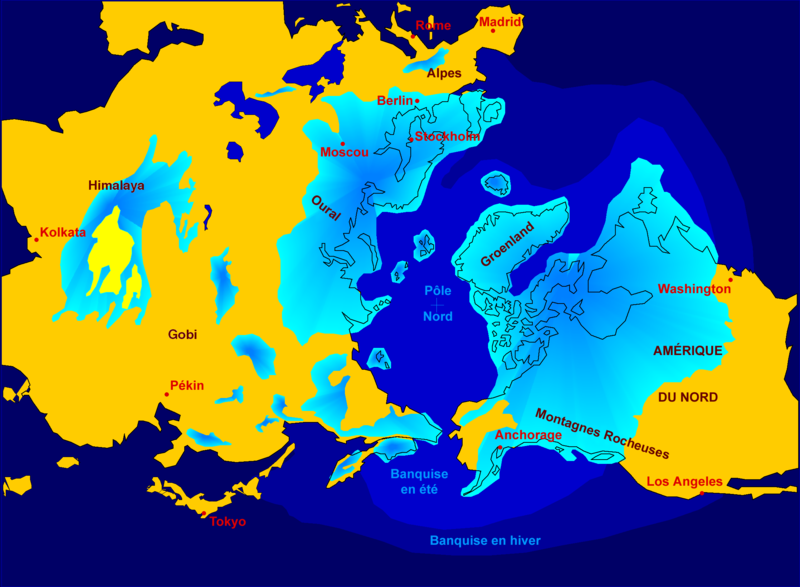
| Descrición | Northern hemisphere glaciation during the last ice ages. The set up of 3 to 4 km thick ice sheets caused a sea level lowering of about 120 m. Also the Alps and the Himalaya were covered by glaciers. The limit of winter sea ice coverage was much more to the south. |
| Data | 2000-04-07, modified October 2006 |
| Orixe | Image:Northern_icesheet_hg.png created by Hannes Grobe |
| Autoría | Hannes Grobe 23:06, 21 July 2006 (UTC), Alfred Wegener Institute for Polar and Marine Research, Bremerhaven, Germany, translated by Sting |
| Licenza (Reuso deste ficheiro) |
share alike, attribution required (Creative Commons CC-BY-SA-2.5) |
| Outras versións |
in English : Image:Northern_icesheet_hg.png USGS map |
Français : * Sujet : Carte de l'hémisphère nord durant la dernière glaciation. Une couche de glace de 3 à 4 km d'épaisseur a entraîné un abaissement du niveau de la mer d'environ 120 m. Les Alpes et l'Himalaya étaient recouverts par des glaciers. L'extension de la banquise en hiver allait bien plus au Sud qu'actuellement ;
- Source : Image:Northern_icesheet_hg.png créée par Hannes Grobe ;
- Auteur : Hannes Grobe, cette version par fr:Sting ;
- Date : Avril 2000, modifications : octobre 2006 ;
- Version originale anglophone : Image:Northern_icesheet_hg.png ;
- Version alternative : carte USGS (lien externe).
Licenza
Este ficheiro está licenciado baixo a licenza Creative Commons recoñecemento compartir igual xenérico 2.5.
- Vostede é libre de:
- compartir – copiar, distribuír e difundir a obra
- facer obras derivadas – adaptar a obra
- Baixo as seguintes condicións:
- recoñecemento – Debe indicar a debida atribución de autoría, fornecer unha ligazón á licenza e indicar se se realizaron cambios. Pode facer isto de calquera forma razoable, mais non nunha forma que indique que quen posúe a licenza apoia ou subscribe o seu uso da obra.
- compartir igual – Se altera, transforma ou amplía este contido, debe publicar as súas contribucións baixo a mesma licenza ou outra compatible á orixinal.
Historial do ficheiro
Prema nunha data/hora para ver o ficheiro tal e como estaba nese momento.
| Data/Hora | Miniatura | Dimensións | Usuario | Comentario | |
|---|---|---|---|---|---|
| actual | 22 de outubro de 2006 ás 19:16 | | 2.236 × 1.640 (402 kB) | Sting | {{Information| |Description=Northern hemisphere glaciation during the last ice ages. The set up of 3 to 4 km thick ice sheets caused a sea level lowering of about 120 m. Also the Alps and the Himalya were covered by glaciers. The limit of winter sea ice c |
Uso do ficheiro
A seguinte páxina usa este ficheiro:
Uso global do ficheiro
Os seguintes wikis empregan esta imaxe:
- Uso en ast.wikipedia.org
- Uso en az.wikipedia.org
- Uso en de.wikipedia.org
- Uso en fr.wikipedia.org
- Pléistocène
- Glaciation
- Inlandsis
- Géographie de la Colombie-Britannique
- Histoire de l'humanité
- Wikipédia:Atelier graphique/Images à améliorer/Archives/Novembre 2006
- Archipel finlandais
- Wikipédia:Sélection/Paléontologie (période géologique)
- Wikipédia:Lumière sur/Pléistocène
- Wikipédia:Oracle/semaine 48 2011
- Utilisateur:Orbitale/Brouillon Dernière période glaciaire
- Dernière période glaciaire
- Climat de l'Arctique
- Uso en ko.wikipedia.org
- Uso en www.wikidata.org