
Ficheiro:Map of USA AK full.png
Non se pode ver nunha resolución meirande.
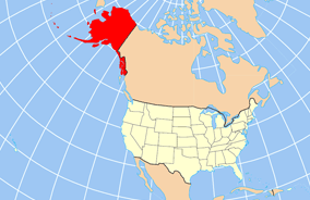
Map_of_USA_AK_full.png (284 × 184 píxeles; tamaño do ficheiro: 19 kB; tipo MIME: image/png)
| Este ficheiro procede de Wikimedia Commons. A continuación móstrase a información da súa páxina de descrición. Commons é un repositorio libre de ficheiros multimedia. Pode contribuír alí cargando as súas imaxes. |

|
File:Map of USA AK full.svg é unha versión vectorial deste ficheiro. Debería usarse esa versión no canto desta imaxe rasterizada cando sexa de mellor calidade.
File:Map of USA AK full.png → File:Map of USA AK full.svg
Para obter máis información acerca de gráficos vectoriais, vaia á páxina sobre a transición a SVG en Commons. Tamén hai información sobre o soporte de MediaWiki de imaxes SVG. |
 |
Resumo
| Descrición | Map of USA with Alaska highlighted and shown in true position |
| Data | |
| Orixe | http://www.nationalatlas.gov/printable/reference.html |
| Autoría | |
| Outras versións | File:Map of USA AK full.svg |
Licenza
This map was obtained from an edition of the National Atlas of the United States. Like almost all works of the U.S. federal government, works from the National Atlas are in the public domain in the United States.
Online access: NationalAtlas.gov | 1970 print edition: Library of Congress, Perry-Castañeda Library
|
Historial do ficheiro
Prema nunha data/hora para ver o ficheiro tal e como estaba nese momento.
| Data/Hora | Miniatura | Dimensións | Usuario | Comentario | |
|---|---|---|---|---|---|
| actual | 17 de decembro de 2012 ás 20:43 | | 284 × 184 (19 kB) | Ras67 | cropped |
| 2 de abril de 2007 ás 16:31 |  | 286 × 186 (20 kB) | MattWright | fix to more standard map colors | |
| 2 de abril de 2007 ás 06:20 |  | 286 × 186 (19 kB) | MattWright | {{Information |Description=Map of USA with Alaska highlighted and shown in true position |Source=http://www.nationalatlas.gov/printable/reference.html |Date=2007-04-02 |Author= |Permission= |other_versions= }} Category:Maps of the United States [[Cat |
Uso do ficheiro
Non hai páxinas que usen este ficheiro.
Uso global do ficheiro
Os seguintes wikis empregan esta imaxe:
- Uso en am.wikipedia.org
- Uso en ar.wikipedia.org
- Uso en az.wikipedia.org
- Uso en az.wiktionary.org
- Uso en ba.wikipedia.org
- Uso en bn.wikipedia.org
- Uso en ce.wikipedia.org
- Uso en cy.wikipedia.org
- Uso en da.wikipedia.org
- Uso en de.wikipedia.org
- Uso en el.wikipedia.org
- Uso en en.wikipedia.org
- Uso en es.wikibooks.org
- Uso en fa.wikipedia.org
- Uso en fr.wikinews.org
- Uso en ga.wikipedia.org
- Sitka
- Buirg Aleutians Thoir, Alasca
- Buirg Anchorage, Alasca
- Buirg Artach Thiar Thuaidh, Alasca
- Buirg Bristol Bay, Alasca
- Buirg Denali, Alasca
- Buirg Fairbanks Réalta Thuaidh, Alasca
- Buirg Haines, Alasca
- Buirg Juneau, Alasca
- Buirg Leithinis Kenai, Alasca
- Buirg Tairseach Ketchikan, Alasca
- Buirg Oileán Kodiak, Alasca
- Buirg Loch agus Leithinis, Alasca
- Buirg Matanuska-Susitna, Alasca
Ollar o uso global deste ficheiro.