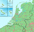
Ficheiro:Koninkrijk der Nederlanden-10-10-10.png

Os contidos da páxina non están dispoñibles noutras linguas.
Na Galipedia, a Wikipedia en galego.

Ficheiro orixinal(1.171 × 1.125 píxeles; tamaño do ficheiro: 327 kB; tipo MIME: image/png)

Descrición
Deutsch: Karte des Königreichs der Niederlande. Das Festland und die Inseln befinden sich auf derselben Ebene.
English: Map of the Kingdom of the Netherlands. The mainland and all the islands are on the same scale.
Nederlands: Kaart van het Koninkrijk der Nederlanden. Het vasteland (Nederland) en de eilanden worden getoond op dezelfde schaal.
Data
Orixe Gebaseerd op/Based on http://www.demis.nl/home/pages/wms/demiswms.htm (free software based on a free database/vrije software gebaseerd op een vrije database)
Autoría Bewerkt door/Edited by Maarten van der Bent
Licenza
(Reuso deste ficheiro)
Public domain
This image is in the public domain because it came from the site https://www.demis.nl/products/web-map-server/examples/ and was released by the copyright holder. Permission is granted to copy, distribute and/or modify this map since it is based on free of copyright images from: www.demis.nl. See also approval email on de.wp and its clarification.

Deutsch | English | македонски | മലയാളം | Nederlands | slovenščina | +/−

Public domain Esta obra foi colocada em domínio público pelo detentor dos direitos autorais, www.demis.nl. Isto se aplica em todo o mundo.
Nalgúns países, isto pode non ser legalmente posible; entón:
www.demis.nl concede a calquera o dereito de empregar esta obra para o propósito que considere oportuno, sen condicións, agás aquelas que sexan requiridas pola lei.

Pés de foto

Engada unha explicación dunha liña do representa este ficheiro

Elementos retratados neste ficheiro

representa a

Historial do ficheiro

Prema nunha data/hora para ver o ficheiro tal e como estaba nese momento.

Data/HoraMiniaturaDimensiónsUsuarioComentario
actual3 de decembro de 2010 ás 14:59Miniatura da versión ás 14:59 do 3 de decembro de 20101.171 × 1.125 (327 kB)LennartBolks~commonswiki{{Information |Description={{de|1=Karte des Königreichs der Niederlande. Das Festland und die Inseln befinden sich auf derselben Ebene.}} {{en|1=Map of the Kingdom of the Netherlands.

A seguinte páxina usa este ficheiro:

Uso global do ficheiro

Os seguintes wikis empregan esta imaxe: