
Ficheiro:Habsburg Map 1547.jpg
Ficheiro orixinal (1.654 × 1.029 píxeles; tamaño do ficheiro: 534 kB; tipo MIME: image/jpeg)
| Este ficheiro procede de Wikimedia Commons. A continuación móstrase a información da súa páxina de descrición. Commons é un repositorio libre de ficheiros multimedia. Pode contribuír alí cargando as súas imaxes. |
Resumo
| Descrición |
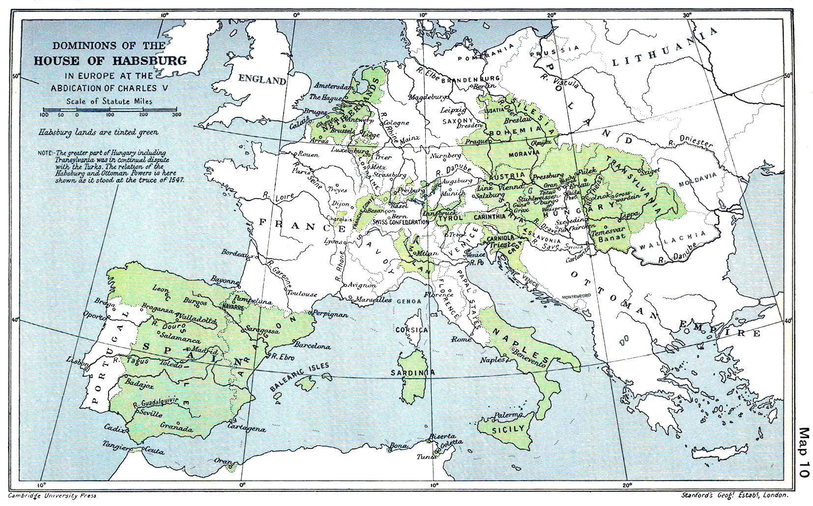
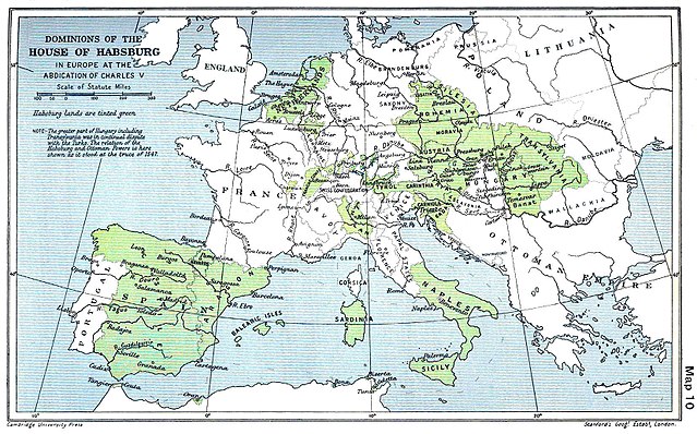
English: A map of the dominion of the Habsburgs following the Battle of Mühlberg (1547) |
| Data | |
| Orixe |
The Cambridge Modern History Atlas, edited by Sir Adolphus William Ward, G.W. Prothero, Sir Stanley Mordaunt Leathes, and E.A. Benians. Cambridge University Press: London, 1912. Editors were Sir Adolphus William Ward (†1924), G.W. Prothero (†1922), and Sir Stanley Mordaunt Leathes (†1938). Individual authors of works making up the atlas are not identified, nor are the likely to be, after reasonable research. |
| Autoría | edited by Sir Adolphus William Ward, G.W. Prothero, Sir Stanley Mordaunt Leathes |
| Outras versións |
|

Licenza
Este arquivo está no dominio público nos Estados Unidos xa que foi publicado antes do 1 de xaneiro de 1929.
Os traballos no dominio público deben ter expirado o seu copyright nos Estados Unidos e no país de orixe para ser subidos a Commons. Se o traballo non é un traballo estadounidense, o ficheiro debe ter unha marca de dereitos de autor adicional indicando o estado do copyright do país de orixe.
|
This UK artistic or literary work, of which the author is unknown and cannot be ascertained by reasonable enquiry, is in the public domain because it is one of the following:
|
 |
Historial do ficheiro
Prema nunha data/hora para ver o ficheiro tal e como estaba nese momento.
| Data/Hora | Miniatura | Dimensións | Usuario | Comentario | |
|---|---|---|---|---|---|
| actual | 29 de marzo de 2018 ás 09:20 | | 1.654 × 1.029 (534 kB) | Trecătorul răcit | Little add: borders of the time |
| 3 de setembro de 2015 ás 11:01 |  | 1.654 × 1.029 (518 kB) | Kurzon | Reverted to version as of 17:22, 9 August 2010 | |
| 3 de setembro de 2015 ás 11:01 |  | 1.654 × 1.029 (518 kB) | Kurzon | Reverted to version as of 17:22, 9 August 2010 | |
| 29 de xuño de 2013 ás 21:33 |  | 1.654 × 1.029 (546 kB) | CSvBibra | add more contrast per request by another user | |
| 9 de agosto de 2010 ás 17:22 |  | 1.654 × 1.029 (518 kB) | CSvBibra | Previously put cleaned up version in new file with "b" after name. Now updating original file with "b" version. Both files uses throughout Wikipedias | |
| 28 de agosto de 2008 ás 09:07 |  | 1.654 × 1.029 (649 kB) | F l a n k e r | Wrap, shadows and minor improvements | |
| 28 de xuño de 2005 ás 14:42 |  | 1.654 × 1.029 (421 kB) | Rythin~commonswiki | A map of the dominion of the Habsburgs following the Battle of Mühlberg (1547). Taken from ''The Cambridge Modern History Atlas,'' edited by Sir Adolphus William Ward, G.W. Prothero, Sir Stanley Mordaunt Leathes, and E.A. Benians. Cambridge University Pr |
Uso do ficheiro
As seguintes 4 páxinas usan este ficheiro:
Uso global do ficheiro
Os seguintes wikis empregan esta imaxe:
- Uso en af.wikipedia.org
- Uso en an.wikipedia.org
- Uso en ar.wikipedia.org
- Uso en arz.wikipedia.org
- Uso en ast.wikipedia.org
- Uso en azb.wikipedia.org
- Uso en ba.wikipedia.org
- Uso en be.wikipedia.org
- Uso en bg.wikipedia.org
- Uso en br.wikipedia.org
- Uso en bs.wikipedia.org
- Uso en ca.wikipedia.org
- Uso en cs.wikipedia.org
- Uso en da.wikipedia.org
- Uso en de.wikipedia.org
- Uso en el.wikipedia.org
- Uso en en.wikipedia.org
Ollar o uso global deste ficheiro.