
Ficheiro:Fukushima I NPP 1975 medium crop rotated labeled.jpg

Tamaño desta vista previa: 300 × 600 píxeles. Outras resolucións: 120 × 240 píxeles | 240 × 480 píxeles.
Ficheiro orixinal (800 × 1.600 píxeles; tamaño do ficheiro: 248 kB; tipo MIME: image/jpeg)
| Este ficheiro procede de Wikimedia Commons. A continuación móstrase a información da súa páxina de descrición. Commons é un repositorio libre de ficheiros multimedia. Pode contribuír alí cargando as súas imaxes. |
Resumo
| Descrición |
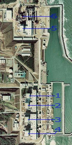
English: Fukushima I Nuclear Power Plant. Medium crop showing reactors labeled 1 to 5 and site for reactor 6. North is up.
日本語: 福島第一原子力発電所。 |
| Data | |
| Orixe | http://w3land.mlit.go.jp/cgi-bin/WebGIS2/WC_AirPhoto.cgi?IT=p&DT=n&PFN=CTO-75-30&PCN=C29B&IDX=21 |
| Autoría | Ministry of Land, Infrastructure, Transport and Tourism |
| Outras versións |
|
| Localización da cámara | | Esta e outras imaxes na súa localización en: OpenStreetMap |
|---|
Licenza

|
O propietario dos dereitos de autor deste ficheiro, the Ministry of Land, Infrastructure, Transport and Tourism of Japan, permite que calquera poida usalo para calquera propósito, sempre e cando se lle recoñeza a autoría a quen cede os dereitos. A redistribución, edición, uso comercial e calquera outro tipo de uso están permitidos. |
Recoñecemento:
Copyright © National Land Image Information (Color Aerial Photographs), Ministry of Land, Infrastructure, Transport and Tourism
|
 |
This image is copyrighted by the Ministry of Land, Infrastructure, Transport and Tourism of Japan. For terms of use, see the stipulation to use of National Land Information (in Japanese) and message from MLIT (in Japanese and English). When you display this image on an article, include the following phrase in the description: "Made based on National Land Image Information (Color Aerial Photographs), Ministry of Land, Infrastructure, Transport and Tourism".
|
Historial do ficheiro
Prema nunha data/hora para ver o ficheiro tal e como estaba nese momento.
| Data/Hora | Miniatura | Dimensións | Usuario | Comentario | |
|---|---|---|---|---|---|
| actual | 15 de marzo de 2011 ás 23:54 | | 800 × 1.600 (248 kB) | 84user | =={{int:filedesc}}== {{Information |Description={{en|1=Fukushima I Nuclear Power Plant. Medium crop showing reactors labeled 1 to 5 and site for reactor 6. North is up.}} {{ja|1=[[:ja:福島第一原子力発電所| |
Uso do ficheiro
A seguinte páxina usa este ficheiro:
Uso global do ficheiro
Os seguintes wikis empregan esta imaxe:
- Uso en ar.wikipedia.org
- Uso en ast.wikipedia.org
- Uso en be-tarask.wikipedia.org
- Uso en ca.wikipedia.org
- Uso en cs.wikipedia.org
- Uso en cv.wikipedia.org
- Uso en de.wikipedia.org
- Uso en de.wikinews.org
- Uso en en.wikipedia.org
- Uso en en.wikibooks.org
- Uso en es.wikipedia.org
- Uso en fi.wikipedia.org
- Uso en fr.wikipedia.org
- Uso en he.wikipedia.org
- Uso en hi.wikipedia.org
- Uso en ja.wikipedia.org
- Uso en ko.wikipedia.org
- Uso en ko.wikinews.org
- Uso en ms.wikipedia.org
- Uso en nl.wikipedia.org
- Uso en pl.wikipedia.org
- Uso en pt.wikipedia.org
- Uso en rm.wikipedia.org
- Uso en ru.wikipedia.org
- Uso en sq.wikinews.org
- Uso en ta.wikipedia.org
- Uso en th.wikipedia.org
- Uso en zh.wikipedia.org