
Ficheiro:Eu cartogram.png
Non se pode ver nunha resolución meirande.
Eu_cartogram.png (490 × 436 píxeles; tamaño do ficheiro: 10 kB; tipo MIME: image/png)
| Este ficheiro procede de Wikimedia Commons. A continuación móstrase a información da súa páxina de descrición. Commons é un repositorio libre de ficheiros multimedia. Pode contribuír alí cargando as súas imaxes. |
Resumo
| Descrición |
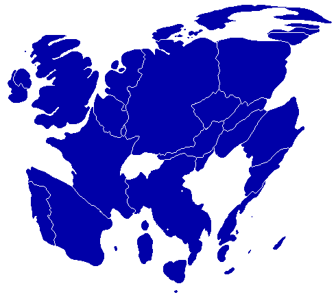
English: A cartogram depicting population distribution within the European Union at the member state level. Note how roughly half of all citizens within the EU live within the 4 largest member states: Germany, France, United Kingdom, and Italy. |
| Data | |
| Orixe | Self-made, referenced from a similiar cartogram at worldmapper.net |
| Autoría | Geoilex |
Licenza
| Eu, como posuidor dos dereitos de autor desta obra, libéroa para que pertenza ao dominio público. Isto é válido en todo o mundo. Nalgúns países, isto pode non ser legalmente posible; entón: Concedo a calquera o dereito de empregar esta obra para o propósito que considere oportuno, sen condicións, agás aquelas que sexan requiridas pola lei. |
Historial do ficheiro
Prema nunha data/hora para ver o ficheiro tal e como estaba nese momento.
| Data/Hora | Miniatura | Dimensións | Usuario | Comentario | |
|---|---|---|---|---|---|
| actual | 27 de marzo de 2008 ás 09:54 | | 490 × 436 (10 kB) | Geoilex | {{Information |Description= A cartogram depicting population distribution within the European Union at the member state level. Note how roughly half of all citizens within the EU live within the 4 largest member states: Germany, France, United Kingdom, an |
| 27 de marzo de 2008 ás 09:47 |  | 490 × 436 (10 kB) | Geoilex | {{Information |Description= A cartogram depicting population distribution within the European Union and the member state level. Note how roughly half of all citizens within the EU live within the 4 largest member states: Germany, France, United Kingdom, a |
Uso do ficheiro
A seguinte páxina usa este ficheiro:
Uso global do ficheiro
Os seguintes wikis empregan esta imaxe:
- Uso en cs.wikipedia.org
- Uso en en.wikipedia.org
- Uso en es.wikipedia.org
- Uso en fr.wikipedia.org
- Uso en he.wikipedia.org
- Uso en it.wikipedia.org
- Uso en it.wikibooks.org
- Uso en nl.wikipedia.org
- Uso en pt.wikipedia.org
- Uso en sv.wikipedia.org
- Uso en uk.wikipedia.org