
Ficheiro:East-Hem 200ad.jpg

Ficheiro orixinal (3.240 × 1.903 píxeles; tamaño do ficheiro: 734 kB; tipo MIME: image/jpeg)
| Este ficheiro procede de Wikimedia Commons. A continuación móstrase a información da súa páxina de descrición. Commons é un repositorio libre de ficheiros multimedia. Pode contribuír alí cargando as súas imaxes. |

|
Esta imaxe (ou todas as imaxes deste artigo ou categoría) deberían volverse crear como imaxes vectoriais SVG. Isto proporciona moitas vantaxes, véxase Commons:Media for cleanup (en inglés) para máis información. Se xa hai unha versión SVG desta imaxe dispoñible, por favor, cárguea en Commons. Tras subila, substitúa este modelo polo modelo {{vector version available|novo nome da imaxe.svg}} nesta imaxe.
|


Resumo
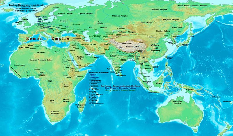
| Descrición | Eastern Hemisphere in 200 AD. |
| Orixe | self-made (For reference information, see the Map Source References section below.) |
| Autoría | Thomas Lessman (Contact!) |
| Licenza (Reuso deste ficheiro) |
Eu, como posuidor dos dereitos de autor desta obra, pola presente publícoa baixo a seguinte licenza: Este ficheiro está licenciado baixo a licenza Creative Commons recoñecemento compartir igual 3.0 sen adaptar.
|
| Outras versións |
Obras derivadas deste ficheiro: Part of East Hem 200 AD.jpg see East-Hem_200ad.jpg file history on Wikipedia. |
Map Summary
Original Source URL: http://www.thomaslessman.com/History/images/East-Hem_200ad.jpg.
This map of the Eastern Hemisphere in 200 AD was created by Thomas Lessman, based on information from the sources listed below. This map is free for educational use (see Permission info above). When using this map, please mention that it is available for free at www.WorldHistoryMaps.info.
Map Source References
- Remember, sources often conflict with each other. This map is only as accurate as the information that is available to me. To report any errors or to help further this work, please click here, or email Thomas Lessman at talessman@yis.us
References for information contained in this map:
Primary Sources:
- 1. The DK Atlas of World History, 2000 Edition; map of The World in 250 CE, (Pages 46-47).
- 2. History and Commercial Atlas of China; map of Asia in 200 AD; available on Huhai.net.
- 3. Countries of the World, 1-1-136 CE cópia arquivada at the Wayback Machine map available on www.WorldHistoryMaps.com.
- 4. Map of the World in 200 CE, created by Wikimedia's User:Javierfv1212.
I - European Information is derived primarily from this Map of Europe in 200 AD from www.Euratlas.com.
II - Asian Information is derived primarily from:
- Han Dynasty borders are derived from the History and Commercial Atlas of China (see above, #2 under Primary Sources).
- Indian borders are derived from a combination of these sources:
- Wikimedia's map of the World in 200 CE, created by User:Javierfv1212.
- This map of the Countries of the World, 1-1-136 CE cópia arquivada at the Wayback Machine, available on www.WorldHistoryMaps.com.
- Wikimedia's map of Western Kshatrapas (Western Satraps), created by User:PHG.
- Wikimedia's Satavahana Map, created by User:PHG.
- Korean borders derive from this map of Korea-204.png made by Wikipedia User:Historiographer.
- Kushan Empire borders are derived from a mix of the sources below:
- The DK Atlas of World History (see above, #1 under Primary Sources).
- History and Commercial Atlas of China (see above, #2 under Primary Sources).
- Parthian Empire borders derive from:
- History and Commercial Atlas of China (see above, #2 under Primary Sources).
- Wikimedia's map of the World in 200 CE (see above, #4 under Primary Sources).
- Roman borders in Asia, along with borders for states in Iraq and Caucasus Mts, are derived from the Map of Europe in 200 AD from www.Euratlas.com.
III - African Information, and fringe areas like Australia, Siberia, etc. derive from:
- Wikimedia's map of the World in 200 CE, created by User:Javierfv1212.
- The DK Atlas of World History, 2000 Edition; map of The development of complex societies in Africa; (Page 160).
Note: Much of the information in this map was cross-checked with Bruce Gordon's Regnal Chronologies.
Other Maps by Thomas Lessman
| Maps of the eastern hemisphere showing history
Bold dates are available on Wikimedia or Wikipedia. | ||
| Primeval | ||
| Ancient
|
·| 600 BC | 550 BC | 527 BC | 500 BC |
400 BC | ·| 1 AD | 50 AD | 100 AD | 200 AD | 300 AD | | |
| Medieval |
·| 500 AD | 565 AD | 600 AD | 700 AD | | |
| Modern |
·| 1500 AD | · * For historical maps of the whole world, | |
Other Info
Historial do ficheiro
Prema nunha data/hora para ver o ficheiro tal e como estaba nese momento.
| Data/Hora | Miniatura | Dimensións | Usuario | Comentario | |
|---|---|---|---|---|---|
| actual | 26 de maio de 2008 ás 00:22 | | 3.240 × 1.903 (734 kB) | Talessman | Corrections to borders in West Asia, India, Southeast Asia, China, and Korea. Added more information based on new references. Other misc. corrections and updates. |
| 9 de maio de 2008 ás 16:27 |  | 3.240 × 1.903 (720 kB) | Talessman | {{Information |Description=Eastern Hemisphere in 200 AD. |Source=self-made |Author=Thomas Lessman |Permission={{self|cc-by-sa-3.0}} }} |
Uso do ficheiro
A seguinte páxina usa este ficheiro:
Uso global do ficheiro
Os seguintes wikis empregan esta imaxe:
- Uso en ar.wikipedia.org
- Uso en be-tarask.wikipedia.org
- Uso en bg.wikipedia.org
- Uso en bn.wikipedia.org
- Uso en bs.wikipedia.org
- Uso en ca.wikipedia.org
- Uso en cv.wikipedia.org
- Uso en de.wikipedia.org
- Uso en el.wikipedia.org
- Uso en en.wikipedia.org
- 3rd century
- 200
- Proto-Mongols
- History of Eurasia
- Chutu dynasty
- Talk:Odia language
- User:Tompw/sandbox10
- User:Talessman/Maps
- User talk:Talessman/Maps
- Timeline of ancient history
- Comparative studies of the Roman and Han empires
- User:Benjamin Trovato/sandbox
- Nagas of Padmavati
- List of Classical Age states
- User:Joelton Ivson/Gather lists/24978 – Os Romanos
- User:Falcaorib
- Achyuta of Panchala
- Uso en en.wikibooks.org
- Uso en en.wikiversity.org
- Uso en eo.wikipedia.org
- Uso en es.wikipedia.org
- Uso en fi.wikipedia.org
- Uso en frr.wikipedia.org
- Uso en he.wikipedia.org
- Uso en hy.wikipedia.org
- Uso en id.wikipedia.org
- Uso en it.wikipedia.org
- Uso en jv.wikipedia.org
- Uso en ko.wikipedia.org
- Uso en lv.wikipedia.org
- Uso en mk.wikipedia.org
Ollar o uso global deste ficheiro.