
Ficheiro:Densidad poblacion Israel.png

Tamaño desta vista previa: 263 × 599 píxeles. Outras resolucións: 105 × 240 píxeles | 211 × 480 píxeles | 692 × 1.575 píxeles.
Ficheiro orixinal (692 × 1.575 píxeles; tamaño do ficheiro: 182 kB; tipo MIME: image/png)
| Este ficheiro procede de Wikimedia Commons. A continuación móstrase a información da súa páxina de descrición. Commons é un repositorio libre de ficheiros multimedia. Pode contribuír alí cargando as súas imaxes. |
| Descrición |
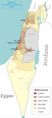
Español: Densidad de población en Israel por región geográfica English: Population density of Israel by geographical region, as defined by the government and CBS |
| Data | (UTC) |
| Orixe | |
| Autoría |
|
| Outras versións |
|


| Esta é unha imaxe retocada,en o que significa que a súa versión orixinal foi alterada dixitalmente. Modificacións: {{{1}}}. A orixinal pódese ver aquí: Israel population density.png. As modificacións realizounas Cansado.
|

|
O propietario dos dereitos de autor deste ficheiro, Israel Central Bureau of Statistics, permite que calquera poida usalo para calquera propósito, sempre e cando se lle recoñeza a autoría a quen cede os dereitos. A redistribución, edición, uso comercial e calquera outro tipo de uso están permitidos. |
Recoñecemento:
The Central Bureau of Statistics (CBS), {{{filename}}}, ({{{access-date}}}), [{{{link}}} available online] copied and distributed as is in accordance with the CBS license.
|

|
According to the CBS license, you may not make the following use of the Information, whether by positive act or by omission:
|
Eu, como posuidor dos dereitos de autor desta obra, pola presente publícoa baixo a seguinte licenza:

|
Autorízase a copia, distribución e/ou modificación deste documento baixo os termos da licenza de documentación libre GNU, versión 1.2 ou calquera outra que posteriormente publique a Free Software Foundation; sen seccións invariables, textos de portada, nin textos de contraportada. Inclúese unha copia da devandita licenza na sección titulada GNU Free Documentation License. |
| Este ficheiro está licenciado baixo a licenza Creative Commons recoñecemento compartir igual 3.0 sen adaptar. | ||
| ||
| A etiqueta desta licenza engadiuse a este ficheiro como parte da actualización da licenza GFDL. |
Rexistro de cargas orixinal
This image is a derivative work of the following images:
- File:Israel_population_density.png licensed with GFDL
- 2008-04-26T13:48:59Z Ynhockey 692x1575 (227122 Bytes) Eh, what a waste of HD space - made small mistake in last version in 112 sub-district (Beit Shemesh).
- 2008-04-26T13:45:05Z Ynhockey 750x1706 (248272 Bytes) Slightly changed coloring scheme - much more clear now IMO.
- 2007-11-03T22:47:21Z Ynhockey 750x1706 (336937 Bytes) Update for 2007, fixed the Jerusalem sub-district (was incorrect in the first place)
- 2007-07-28T01:36:07Z Ynhockey 750x1706 (337336 Bytes) More pronounced borders on districts, reduced width.
- 2007-07-28T01:29:22Z Ynhockey 822x1575 (326837 Bytes) {{Information |Description=Population density of Israel by geographical region, as defined by the government and CBS. |Source=self-made |Date=July 28, 2007 |Author= [[User:Ynhockey|Ynhockey]] }} {{GFDL-self}}
Carregada com derivativeFX
Historial do ficheiro
Prema nunha data/hora para ver o ficheiro tal e como estaba nese momento.
| Data/Hora | Miniatura | Dimensións | Usuario | Comentario | |
|---|---|---|---|---|---|
| actual | 11 de marzo de 2009 ás 03:48 | | 692 × 1.575 (182 kB) | Cansado | {{Information |Description=Population density of Israel by geographical region, as defined by the government and CBS. |Source=*File:Israel_population_density.png |Date=2009-03-11 03:47 (UTC) |Author=*File:Israel_population_density.png: [[User: |
Uso do ficheiro
A seguinte páxina usa este ficheiro:
Uso global do ficheiro
Os seguintes wikis empregan esta imaxe:
- Uso en ast.wikipedia.org
- Uso en es.wikipedia.org
- Uso en pt.wikipedia.org