
Ficheiro:Cvijic, Jovan - Breisemeister, William A. - Carte ethnographique de la Péninsule balkanique (pd).jpg

Ficheiro orixinal (1.194 × 1.024 píxeles; tamaño do ficheiro: 2,24 MB; tipo MIME: image/jpeg)
| Este ficheiro procede de Wikimedia Commons. A continuación móstrase a información da súa páxina de descrición. Commons é un repositorio libre de ficheiros multimedia. Pode contribuír alí cargando as súas imaxes. |
.jpg)
Resumo
| Descrición |
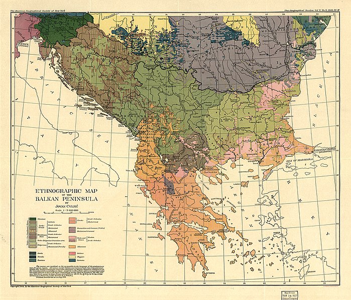
Français : La dissolution de l'empire austro-hongrois à la fin de la Première Guerre mondiale transforma l'organisation politique des Balkans. La guerre avait commencé dans les Balkans avec l'assassinat de l'archiduc François-Ferdinand de Habsbourg par un militant serbe de Bosnie qui voulait l'indépendance de son pays vis à vis du double empire. Jovan Cvijic, l'auteur de cette "carte ethnographique" des Balkans, publiée en 1918 par la Société géographique américaine de New York, était professeur de géographie à l'université de Belgrade. Cvijic termina son doctorat à l'université de Vienne dans les années 1890 en formations géologiques et géomorphologie physique, mais ses centres d'intérêts se tournèrent plus tard vers la recherche "anthropogéographique" analysant les influences géographiques sur la dynamique ethnique et culturelle dans la péninsule des Balkans. La carte de Cvijic est un témoignage de la diversité ethnique, religieuse, et nationale des Balkans, mais elle donne peu de notion des dommages démographiques que la guerre causa sur la péninsule, où l'on estime qu'un quart des populations d'avant-guerre de la Serbie et du Monténégro disparut, l'un des plus haut taux de victimes de tous les pays combattants.
English: "The dissolution of the Austro-Hungarian Empire at the end of World War I transformed the political organization of the Balkans. The war had started in the Balkans with the assassination of the Habsburg Archduke Franz Ferdinand by a militant Bosnian Serb seeking independence for his country from the dual empire. Jovan Cvijić, the author of this “ethnographic map” of the Balkans, published in 1918 by the American Geographical Society of New York, was a professor of geography at the University of Belgrade. Cvijić completed his doctorate at the University of Vienna in the 1890s on geological formations and physical geomorphology, but his interests later shifted to “anthropogeographical” research analyzing the geographical influences on ethnic and cultural dynamics in the Balkan Peninsula. Cvijić’s map is a testament to the ethnic, religious, and national diversity of the Balkans, but it provides little sense of the demographic damage that the war wreaked on the peninsula, where an estimated one-quarter of the prewar populations of Serbia and Montenegro were killed, one of the highest casualty rates of any combatant country." |
||||
| Data | |||||
| Orixe | http://www.wdl.org/fr/item/93/ | ||||
| Autoría | Cvijic, Jovan ; Breisemeister, William A. | ||||
| Licenza (Reuso deste ficheiro) |
|
||||
Historial do ficheiro
Prema nunha data/hora para ver o ficheiro tal e como estaba nese momento.
| Data/Hora | Miniatura | Dimensións | Usuario | Comentario | |
|---|---|---|---|---|---|
| actual | 31 de xaneiro de 2022 ás 13:15 | | 1.194 × 1.024 (2,24 MB) | Buli | Reverted to version as of 11:13, 22 April 2009 (UTC) |
| 31 de xaneiro de 2022 ás 13:12 |  | 1.576 × 1.351 (500 kB) | Buli | higher resolution | |
| 22 de abril de 2009 ás 11:13 |  | 1.194 × 1.024 (2,24 MB) | ComputerHotline | {{Information |Description={{fr|La dissolution de l'empire austro-hongrois à la fin de la Première Guerre mondiale transforma l'organisation politique des Balkans. La guerre avait commencé dans les Balkans avec l'assassinat de l'archiduc François-Ferd |
Uso do ficheiro
A seguinte páxina usa este ficheiro:
Uso global do ficheiro
Os seguintes wikis empregan esta imaxe:
- Uso en bg.wikipedia.org
- Uso en de.wikipedia.org
- Uso en en.wikipedia.org
- Uso en hr.wikipedia.org
- Uso en hu.wikipedia.org
- Uso en it.wikipedia.org
- Uso en mk.wikipedia.org
- Uso en sh.wikipedia.org
- Uso en sr.wikipedia.org
.jpg)