
Ficheiro:Cornubian batholith.png

Tamaño desta vista previa: 800 × 479 píxeles. Outras resolucións: 320 × 192 píxeles | 640 × 383 píxeles | 1.024 × 613 píxeles | 1.471 × 881 píxeles.
Ficheiro orixinal (1.471 × 881 píxeles; tamaño do ficheiro: 480 kB; tipo MIME: image/png)
| Este ficheiro procede de Wikimedia Commons. A continuación móstrase a información da súa páxina de descrición. Commons é un repositorio libre de ficheiros multimedia. Pode contribuír alí cargando as súas imaxes. |
Resumo
| Descrición |
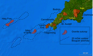
English: Map of the Cornubian batholith and the Haig Fras granite, outcrops taken from various published maps and 20 mGal Bouguer gravity contour taken from Edwards 1984 [1] and Taylor 2007 [2] - base is a snapshot from NASA World Wind software. The granite intrusions are lower in density than the average for the upper part of the continental crust and therefore show up as a negative anomaly where the observed gravitational field has been corrected for the effects of topography (the Bouguer correction). The 20 mGal contour is there to show the extent of this negative anomaly. |
| Data | |
| Orixe | Obra propia |
| Autoría | Mikenorton |
Licenza
Eu, como posuidor dos dereitos de autor desta obra, pola presente publícoa baixo as seguintes licenzas:
Este ficheiro está licenciado baixo a licenza Creative Commons recoñecemento compartir igual 3.0 sen adaptar.
- Vostede é libre de:
- compartir – copiar, distribuír e difundir a obra
- facer obras derivadas – adaptar a obra
- Baixo as seguintes condicións:
- recoñecemento – Debe indicar a debida atribución de autoría, fornecer unha ligazón á licenza e indicar se se realizaron cambios. Pode facer isto de calquera forma razoable, mais non nunha forma que indique que quen posúe a licenza apoia ou subscribe o seu uso da obra.
- compartir igual – Se altera, transforma ou amplía este contido, debe publicar as súas contribucións baixo a mesma licenza ou outra compatible á orixinal.

|
Autorízase a copia, distribución e/ou modificación deste documento baixo os termos da licenza de documentación libre GNU, versión 1.2 ou calquera outra que posteriormente publique a Free Software Foundation; sen seccións invariables, textos de portada, nin textos de contraportada. Inclúese unha copia da devandita licenza na sección titulada GNU Free Documentation License. |
Pode seleccionar a licenza que desexe.
Historial do ficheiro
Prema nunha data/hora para ver o ficheiro tal e como estaba nese momento.
| Data/Hora | Miniatura | Dimensións | Usuario | Comentario | |
|---|---|---|---|---|---|
| actual | 17 de xaneiro de 2011 ás 00:49 | | 1.471 × 881 (480 kB) | Mikenorton | Corrected spelling of Carnmenellis |
| 4 de xaneiro de 2011 ás 23:30 |  | 1.471 × 881 (480 kB) | Mikenorton | {{Information |Description={{en|1=Map of the Cornubian batholith and the Haig Fras granite, outcrops taken from various published maps and 20 mGal Bouguer gravity contour taken from Edwards 1984 [http://sp.lyellcollection.org/cgi/content/abstract/14/1/119 |
Uso do ficheiro
A seguinte páxina usa este ficheiro:
Uso global do ficheiro
Os seguintes wikis empregan esta imaxe:
- Uso en de.wikipedia.org
- Uso en en.wikipedia.org
- Uso en es.wikipedia.org
- Uso en pt.wikipedia.org
- Uso en sl.wikipedia.org
- Uso en vi.wikipedia.org