Ficheiro:Arab population israel 2000 en.png
Os contidos da páxina non están dispoñibles noutras linguas.
Na Galipedia, a Wikipedia en galego.

Ficheiro orixinal(692 × 1.575 píxeles; tamaño do ficheiro: 182 kB; tipo MIME: image/png)

Resumo

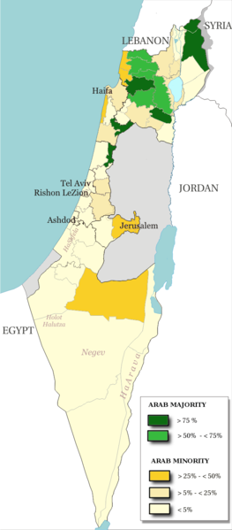
Descrición
English: Map of the officials 50 "natural regions" of Israel, with their proportions of arab population. The map includ the Golan heights and east Jerusalem, two areas annexed by Israel, annexions not recognize by UNO. The map is based on the demographic situation 2000, and is based upon the arab population in Israel [PDF], a publication (Statistilite N°27) of the israeli Center Bureau of Statistics (CBS) diffused in november 2002.
Français : Carte des 50 "régions naturelles" officiellement reconnues par l'état, subdivision des 15 sous-districts, avec la proportion de population arabe. Cette carte inclue Jérusalem-Est et le plateau du Golan, tous deux annexés par Israël, mais dont l'annexion n'est pas reconnue par l'ONU. La carte est basée sur la situation de la population en l'an 2000, et est inspirée de the arab population in Israel [PDF], une publication (Statistilite N°27) du Center Bureau of Statistics israélien (CBS) diffusée en novembre 2002.
Data
Orixe Own work, derivative work of: File:Israel population density.png
Autoría Christophe cagé
Outras versións File:Arabe population israel 2000 fr.png

Licenza

© O propietario dos dereitos de autor deste ficheiro, Israel Central Bureau of Statistics, permite que calquera poida usalo para calquera propósito, sempre e cando se lle recoñeza a autoría a quen cede os dereitos. A redistribución, edición, uso comercial e calquera outro tipo de uso están permitidos.
Recoñecemento:
The Central Bureau of Statistics (CBS), {{{filename}}}, ({{{access-date}}}), [{{{link}}} available online] copied and distributed as is in accordance with the CBS license.

{{{template}}} According to the CBS license, you may not make the following use of the Information, whether by positive act or by omission:
  • present the Information in a misleading manner;
  • present the Information in a way that suggests that the Central Bureau of Statistics, or the State of Israel, supports or endorses you or your use of the Information;
  • make use of the Information in a manner that breaches any applicable law;
  • make use of the Information in a manner that infringes a person's privacy, including merging the Information with other sources of information with the intent of attempting to identify any individual person, business or organization;
  • present the Information in such a manner that gives the appearance that you may have received, or had access to, information held by the Office about any identifiable individual person, business or organization.
Eu, como posuidor dos dereitos de autor desta obra, pola presente publícoa baixo as seguintes licenzas:
GNU head Autorízase a copia, distribución e/ou modificación deste documento baixo os termos da licenza de documentación libre GNU, versión 1.2 ou calquera outra que posteriormente publique a Free Software Foundation; sen seccións invariables, textos de portada, nin textos de contraportada. Inclúese unha copia da devandita licenza na sección titulada GNU Free Documentation License.
w:gl:Creative Commons
recoñecemento compartir igual
Vostede é libre de:
  • compartir – copiar, distribuír e difundir a obra
  • facer obras derivadas – adaptar a obra
Baixo as seguintes condicións:
  • recoñecemento – Debe indicar a debida atribución de autoría, fornecer unha ligazón á licenza e indicar se se realizaron cambios. Pode facer isto de calquera forma razoable, mais non nunha forma que indique que quen posúe a licenza apoia ou subscribe o seu uso da obra.
  • compartir igual – Se altera, transforma ou amplía este contido, debe publicar as súas contribucións baixo a mesma licenza ou outra compatible á orixinal.
Pode seleccionar a licenza que desexe.

Pés de foto

Engada unha explicación dunha liña do representa este ficheiro

Elementos retratados neste ficheiro

representa a

5afc0b91dfe8d983a85af862f3a58ec981a8a743

tamanho dos dados portugués

186.138 Byte

1.575 píxel

692 píxel

Historial do ficheiro

Prema nunha data/hora para ver o ficheiro tal e como estaba nese momento.

Data/HoraMiniaturaDimensiónsUsuarioComentario
actual15 de xullo de 2014 ás 13:48Miniatura da versión ás 13:48 do 15 de xullo de 2014692 × 1.575 (182 kB)Hruska~commonswikiReverted to version as of 08:23, 22 February 2009
15 de xullo de 2014 ás 13:47Miniatura da versión ás 13:47 do 15 de xullo de 2014692 × 1.575 (182 kB)Hruska~commonswikiReverted to version as of 08:23, 22 February 2009 Revert Edit, The Golan and East Jerusalem de facto Israel, Syria giving Status qo
15 de xullo de 2014 ás 13:46Miniatura da versión ás 13:46 do 15 de xullo de 2014692 × 1.575 (182 kB)Hruska~commonswikiReverted to version as of 08:23, 22 February 2009
21 de abril de 2009 ás 15:38Miniatura da versión ás 15:38 do 21 de abril de 2009692 × 1.575 (165 kB)MeteorMaker~commonswiki{{Information |Description={{en|1=Map of the officials 50 "natural regions" of Israel, with their proportions of arab population. The map includ the Golan heights and east Jerusalem, two areas annexed by Israel, annexions not recognize by UNO. The map is
22 de febreiro de 2009 ás 08:23Miniatura da versión ás 08:23 do 22 de febreiro de 2009692 × 1.575 (182 kB)Christophe cagé{{Information |Description={{en|1=x}} {{fr|1=x}} |Source=travail personnel (own work) |Author=Christophe cagé |Date=22 february 2009 |Permission=SEE LICENSE |other_versions= }} <!--{{ImageUpload|full}}-->

A seguinte páxina usa este ficheiro:

Uso global do ficheiro

Os seguintes wikis empregan esta imaxe:

Metadatos