
Ficheiro:1822 Geographical, Statistical, and Historical Map of Florida by Henry Charles Carey, Isaac Lea and Fielding Lucas.png

Tamaño desta vista previa: 498 × 599 píxeles. Outras resolucións: 199 × 240 píxeles | 399 × 480 píxeles | 804 × 967 píxeles.
Ficheiro orixinal (804 × 967 píxeles; tamaño do ficheiro: 1,39 MB; tipo MIME: image/png)
| Este ficheiro procede de Wikimedia Commons. A continuación móstrase a información da súa páxina de descrición. Commons é un repositorio libre de ficheiros multimedia. Pode contribuír alí cargando as súas imaxes. |
Resumo
| Descrición |
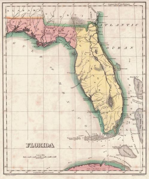
English: 1822 map of Florida Territory, published less then a year after Florida was ceded to the U.S. by Spain. The map delineates the territory's two original counties – Escambia and St. Johns, whose initial boundaries were conterminous with those of the earlier districts of East and West Florida. The interior river system is still largely anecdote and conjecture. Two roads lead west out of St. Augustine, one to Rollstown on the St. Johns River and the other to Ivitachua. A number of early northern forts are listed, including Ft. Barancas, Ft. Gadsden or Collinton, Ft. St. Marks, Ft. Poppa, Picolota Ft., and a British Fort erected during the war on the Apalachicola River. |
| Data | |
| Orixe |
Original publication: A Complete Historical, Chronological, And Geographical American Atlas, Being A Guide To The History Of North And South America, And The West Indies ... To The Year 1822. According To The Plan Of Le Sage's Atlas And Intended As A Companion To Lavoisne's Improvement Of That Celebrated Work." (Philadelphia, PA: Carey and Lea, 1822) |
| Autoría |
Henry Charles Carey, Isaac Lea, Fielding Lucas |
- Other information
English: This is an image of an original map that is in the public domain. This image is not a derivative work of the original map, as it has not been improved through techniques such as cutting out backgrounds, fixing broken lines, simplification, sharpening or otherwise cleaning up.
Licenza
Este arquivo está no dominio público nos Estados Unidos xa que foi publicado antes do 1 de xaneiro de 1929.
Os traballos no dominio público deben ter expirado o seu copyright nos Estados Unidos e no país de orixe para ser subidos a Commons. Se o traballo non é un traballo estadounidense, o ficheiro debe ter unha marca de dereitos de autor adicional indicando o estado do copyright do país de orixe.
|
Historial do ficheiro
Prema nunha data/hora para ver o ficheiro tal e como estaba nese momento.
| Data/Hora | Miniatura | Dimensións | Usuario | Comentario | |
|---|---|---|---|---|---|
| actual | 30 de xaneiro de 2016 ás 13:16 | | 804 × 967 (1,39 MB) | Jeff in CA | re-cropped image |
| 30 de xaneiro de 2016 ás 10:40 |  | 830 × 984 (1,82 MB) | Jeff in CA | {{subst:Upload marker added by en.wp UW}} {{Information |Description = {{en|One of the earliest obtainable separate maps of Florida following its admission as a Territory in July 1821, the map pre-dates all but St. John's County, with the only delineat... |
Uso do ficheiro
A seguinte páxina usa este ficheiro:
Uso global do ficheiro
Os seguintes wikis empregan esta imaxe:
- Uso en ar.wikipedia.org
- Uso en bn.wikipedia.org
- Uso en br.wikipedia.org
- Uso en en.wikipedia.org
- Uso en es.wikipedia.org
- Uso en et.wikipedia.org
- Uso en he.wikipedia.org
- Uso en mt.wikipedia.org
- Uso en pt.wikipedia.org
- Uso en sr.wikipedia.org
- Uso en tr.wikipedia.org
- Uso en vi.wikipedia.org