
Ficheiro:Map of Rhode Island NA.png
Tamaño desta vista previa: 776 × 600 píxeles. Outras resolucións: 311 × 240 píxeles | 621 × 480 píxeles | 994 × 768 píxeles | 1.280 × 989 píxeles | 2.122 × 1.640 píxeles.
Ficheiro orixinal (2.122 × 1.640 píxeles; tamaño do ficheiro: 822 kB; tipo MIME: image/png)
| Este ficheiro procede de Wikimedia Commons. A continuación móstrase a información da súa páxina de descrición. Commons é un repositorio libre de ficheiros multimedia. Pode contribuír alí cargando as súas imaxes. |
Resumo
| Descrición |
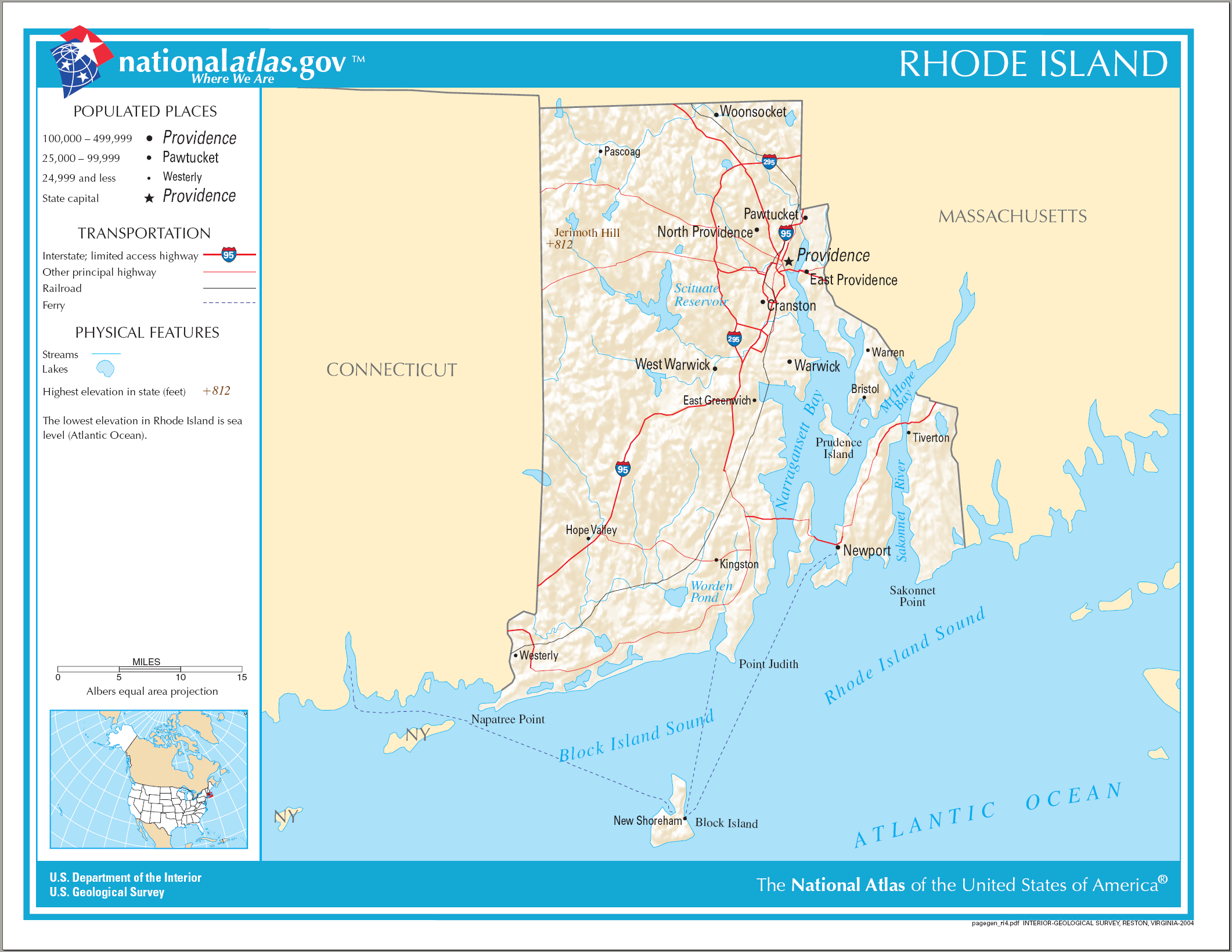
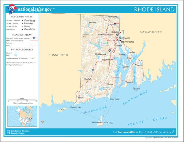
English: National Atlas map of Rhode Island. |
| Data | |
| Orixe | National Atlas |
| Autoría |
Licenza
This map was obtained from an edition of the National Atlas of the United States. Like almost all works of the U.S. federal government, works from the National Atlas are in the public domain in the United States.
Online access: NationalAtlas.gov | 1970 print edition: Library of Congress, Perry-Castañeda Library
|
Historial do ficheiro
Prema nunha data/hora para ver o ficheiro tal e como estaba nese momento.
| Data/Hora | Miniatura | Dimensións | Usuario | Comentario | |
|---|---|---|---|---|---|
| actual | 17 de abril de 2015 ás 14:16 | | 2.122 × 1.640 (822 kB) | RokerHRO | optipng -o7 -i0 → 18.34% decrease |
| 15 de agosto de 2006 ás 08:22 |  | 2.122 × 1.640 (1.007 kB) | Huebi~commonswiki | {{Information| |Description=Map of Rhode Island |Source=[http://www.nationalatlas.gov National Atlas] }} Category:Maps of the United States Category:Maps of Rhode Island {{PD-USGov-Atlas}} |
Uso do ficheiro
A seguinte páxina usa este ficheiro:
Uso global do ficheiro
Os seguintes wikis empregan esta imaxe:
- Uso en ang.wikipedia.org
- Uso en be.wikipedia.org
- Uso en ca.wikipedia.org
- Uso en de.wikipedia.org
- Uso en en.wikipedia.org
- Uso en fi.wikipedia.org
- Uso en ga.wikipedia.org
- Uso en hu.wikipedia.org
- Uso en hy.wikipedia.org
- Uso en ja.wikipedia.org
- Uso en ko.wikipedia.org
- Uso en lt.wikipedia.org
- Uso en mhr.wikipedia.org
- Uso en mr.wikipedia.org
- Uso en os.wikipedia.org
- Uso en sw.wikipedia.org
- Uso en tg.wikipedia.org
- Uso en tt.wikipedia.org
- Uso en www.wikidata.org
- Uso en zea.wikipedia.org