
Ficheiro:WGS84 angle to distance conversion.svg

Tamaño desta vista previa en PNG do ficheiro en formato SVG: 512 × 410 píxeles. Outras resolucións: 300 × 240 píxeles | 600 × 480 píxeles | 959 × 768 píxeles | 1.279 × 1.024 píxeles | 2.558 × 2.048 píxeles.
Ficheiro orixinal (ficheiro SVG; resolución de 512 × 410 píxeles; tamaño do ficheiro: 115 kB)
| Este ficheiro procede de Wikimedia Commons. A continuación móstrase a información da súa páxina de descrición. Commons é un repositorio libre de ficheiros multimedia. Pode contribuír alí cargando as súas imaxes. |
Resumo
| Descrición |
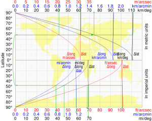
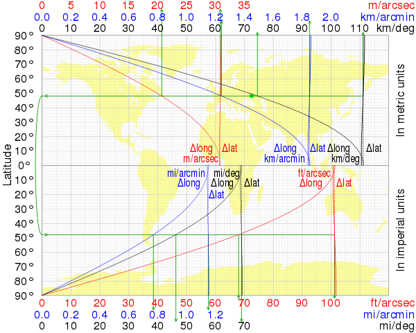
English: Length of one degree (black), minute (blue) and second (red) of latitude and longitude in metric (upper half) and imperial (lower half) units at a given latitude in WGS84 by CMG Lee. For comparison, dotted lines denote corresponding lengths assuming a spherical Earth of IUGG mean radius (R1 = 6,371.0088 km). For example, the green arrows show that Donetsk (green circle) at 48°N has a Δlong of 74.63 km/deg, 1.244 km/arcmin, 20.73 m/arcsec etc and a Δlat of 111.2 km/deg, 1.853 km/arcmin, 30.89 m/arcsec etc. The background bitmap is from http://commons.wikimedia.org/wiki/File:Equirectangular_with_Tissot%27s_Indicatrices_of_Distortion.svg . |
|
| Data | ||
| Orixe |
|
|
| Autoría | cmglee, Justin Kunimune |

Licenza
Este ficheiro está licenciado baixo a licenza Creative Commons recoñecemento compartir igual 4.0 internacional.
- Vostede é libre de:
- compartir – copiar, distribuír e difundir a obra
- facer obras derivadas – adaptar a obra
- Baixo as seguintes condicións:
- recoñecemento – Debe indicar a debida atribución de autoría, fornecer unha ligazón á licenza e indicar se se realizaron cambios. Pode facer isto de calquera forma razoable, mais non nunha forma que indique que quen posúe a licenza apoia ou subscribe o seu uso da obra.
- compartir igual – Se altera, transforma ou amplía este contido, debe publicar as súas contribucións baixo a mesma licenza ou outra compatible á orixinal.
Historial do ficheiro
Prema nunha data/hora para ver o ficheiro tal e como estaba nese momento.
| Data/Hora | Miniatura | Dimensións | Usuario | Comentario | |
|---|---|---|---|---|---|
| actual | 19 de setembro de 2018 ás 21:57 | | 512 × 410 (115 kB) | Cmglee | User created page with UploadWizard |
Uso do ficheiro
A seguinte páxina usa este ficheiro:
Uso global do ficheiro
Os seguintes wikis empregan esta imaxe:
- Uso en en.wikipedia.org