
Ficheiro:Western Empire-Europe870.JPG
Western_Empire-Europe870.JPG (428 × 317 píxeles; tamaño do ficheiro: 83 kB; tipo MIME: image/jpeg)
| Este ficheiro procede de Wikimedia Commons. A continuación móstrase a información da súa páxina de descrición. Commons é un repositorio libre de ficheiros multimedia. Pode contribuír alí cargando as súas imaxes. |
Resumo
| Descrición |
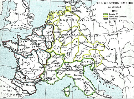
English: Frank king Charlemagne's kingdom survived the leader and covered much of Western Europe from 795 until 843 when a treaty split it amongst his grandsons: Central Franks ruled by w:Lothar I (green), East Franks ruled by w:Louis the German (yellow), and w:Charles the Bald led West Franks (purple). This particular map is from the Atlas to Freeman's Historical Geography, edited by J.B. Bury, Longmans Green and Co. Third Edition 1903. It is in the public domain and you may download it or print it for any use. |
| Data | |
| Orixe | Atlas To Freeman's Historical Geography |
| Autoría | J.B. Bury |
Transferido de en.wikipedia a Wikimedia Commons por Maksim.
Rexistro de cargas orixinal ====
|
Este material está no dominio público nos demais países onde os dereitos de autor se estenden por 70 anos (ou menos) trala morte do autor.
| |
| Este ficheiro foi identificado como libre de restricións baixo as leis de dereitos de autor, incluídos todos os dereitos relacionados. | |
Historial do ficheiro
Prema nunha data/hora para ver o ficheiro tal e como estaba nese momento.
| Data/Hora | Miniatura | Dimensións | Usuario | Comentario | |
|---|---|---|---|---|---|
| actual | 22 de xaneiro de 2006 ás 14:21 | | 428 × 317 (83 kB) | Maksim | La bildo estas kopiita de wikipedia:en. La originala priskribo estas: Frank king Charlemagne's kingdom survived the leader and covered much of Western Europe from 795 until 843 when a treaty split it amongst his grandsons: Cen |
Uso do ficheiro
A seguinte páxina usa este ficheiro:
Uso global do ficheiro
Os seguintes wikis empregan esta imaxe:
- Uso en ar.wikipedia.org
- Uso en ca.wikipedia.org
- Uso en cs.wikipedia.org
- Uso en da.wikipedia.org
- Uso en de.wikipedia.org
- Uso en en.wikipedia.org
- Uso en eo.wikipedia.org
- Uso en es.wikipedia.org
- Uso en et.wikipedia.org
- Uso en it.wikipedia.org
- Uso en ja.wikipedia.org
- Uso en la.wikipedia.org
- Uso en no.wikipedia.org
- Uso en pl.wikipedia.org
- Uso en sh.wikipedia.org
- Uso en simple.wikipedia.org