
Ficheiro:Stone Plan.jpg

Ficheiro orixinal (4.016 × 4.252 píxeles; tamaño do ficheiro: 1,91 MB; tipo MIME: image/jpeg)
| Este ficheiro procede de Wikimedia Commons. A continuación móstrase a información da súa páxina de descrición. Commons é un repositorio libre de ficheiros multimedia. Pode contribuír alí cargando as súas imaxes. |
Resumo
Druidic Calendar
| Descrición |
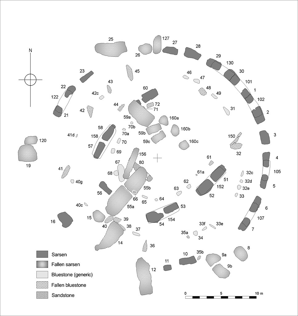
English: Plan of the central Stone Structure at Stonehenge as it survives today. Stone numbers are those conventionally used in the recent literature and following Petrie, F. 1880.
Note that the Term 'Sarsen' used on the key refers to the hard silicified tertiary rock local to the chalkland of the Stonehenge region, sarsen is an exceptionally obdurate form of sandstone: The reference to sandstone on the key is to other ‘non sarsen’ material. The term ‘bluestone’ conveniently, though somewhat controversially, describes a generic group of igneous rock exotic to Salisbury Plain. The major group of bluestones visible today are dolerite - whose province is regarded as south west Wales. A number of other igneous rocks are represented within the arrays. Those interested in the exact make up of the blustone assemblage are referred to Cleal 1995, and Cunliffe and Renfrew 1997. Cleal, R. M. J., Walker, K. E. & Montague, R., Stonehenge in its landscape (English Heritage, London, 1995) Cunliffe, B. & Renfrew, C. Science and Stonhenge (Proceedings of the British Academy - 92, Oxford University Press 1997) Johnson, A. Solving Stonehenge (Thames & Hudson 2008) |
| Data | |
| Orixe | Drawn by Author , a computer compilation of data from various surveys. |
| Autoría | Anthony Johnson |
| Licenza (Reuso deste ficheiro) |
By Author ©Anthony Johnson 2008 |
Licenza

|
Autorízase a copia, distribución e/ou modificación deste documento baixo os termos da licenza de documentación libre GNU, versión 1.2 ou calquera outra que posteriormente publique a Free Software Foundation; sen seccións invariables, textos de portada, nin textos de contraportada. Inclúese unha copia da devandita licenza na sección titulada GNU Free Documentation License. |
- Vostede é libre de:
- compartir – copiar, distribuír e difundir a obra
- facer obras derivadas – adaptar a obra
- Baixo as seguintes condicións:
- recoñecemento – Debe indicar a debida atribución de autoría, fornecer unha ligazón á licenza e indicar se se realizaron cambios. Pode facer isto de calquera forma razoable, mais non nunha forma que indique que quen posúe a licenza apoia ou subscribe o seu uso da obra.
Historial do ficheiro
Prema nunha data/hora para ver o ficheiro tal e como estaba nese momento.
| Data/Hora | Miniatura | Dimensións | Usuario | Comentario | |
|---|---|---|---|---|---|
| actual | 27 de setembro de 2008 ás 14:04 | | 4.016 × 4.252 (1,91 MB) | Sitehut~commonswiki | {{Information |Description={{en|1=Plan of the central stone structure at Stonehenge as it survives today. Conventional stone numbers shown. A eversion of the plan reproduced in 'Solving Stonehenge' (Thames & Hudson 2008).}} |Source=Drawn by Author , a com |
Uso do ficheiro
A seguinte páxina usa este ficheiro:
Uso global do ficheiro
Os seguintes wikis empregan esta imaxe:
- Uso en as.wikipedia.org
- Uso en de.wikipedia.org
- Uso en en.wikipedia.org
- Uso en es.wikipedia.org
- Uso en frr.wikipedia.org
- Uso en fr.wikipedia.org
- Uso en fy.wikipedia.org
- Uso en hr.wikipedia.org
- Uso en kw.wikipedia.org
- Uso en mt.wikipedia.org
- Uso en nl.wikipedia.org
- Uso en scn.wikipedia.org
- Uso en sr.wikipedia.org
- Uso en vi.wikipedia.org