
Ficheiro:Paramushir, Atlasov, Shumshu - Landsat 7.jpg

Tamaño desta vista previa: 542 × 599 píxeles. Outras resolucións: 217 × 240 píxeles | 434 × 480 píxeles | 695 × 768 píxeles | 926 × 1.024 píxeles | 1.852 × 2.048 píxeles | 3.600 × 3.980 píxeles.
Ficheiro orixinal (3.600 × 3.980 píxeles; tamaño do ficheiro: 3,16 MB; tipo MIME: image/jpeg)
| Este ficheiro procede de Wikimedia Commons. A continuación móstrase a información da súa páxina de descrición. Commons é un repositorio libre de ficheiros multimedia. Pode contribuír alí cargando as súas imaxes. |
Resumo
Čeština: Paramušir ( rusky Остров Парамушир; japonsky: 幌筵島, Paramuširu-tó nebo Horomuširo-tó; v ainštině znamená široká země (poro mošir)) je největším ostrovem severní části Kurilského souostroví a zároveň druhým největším ostrovem celého souostroví po ostrově Iturup.
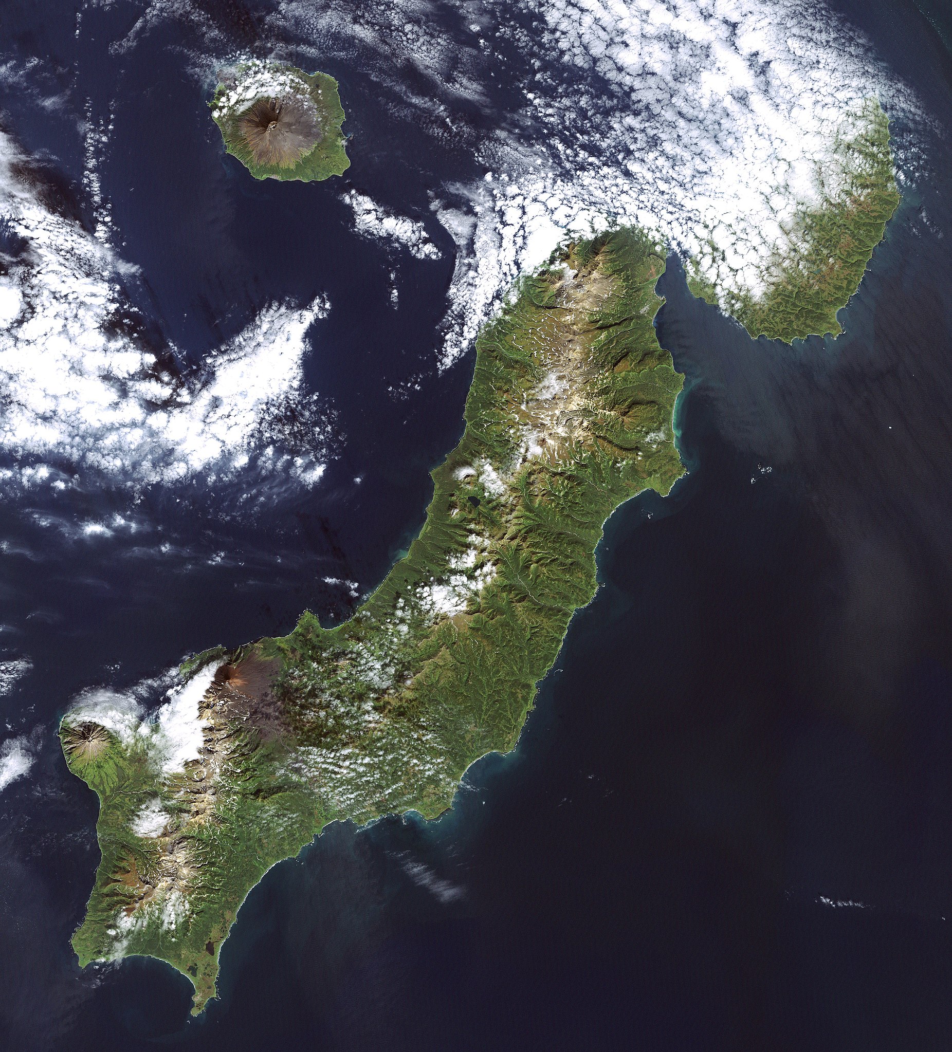
English: Paramushir () or Paramushiro is the second largest of the Kuril Islands, lying near the north of the archipelago. It is governed by Russia. It is home to several volcanoes, including Fuss Peak at 1,772m and Chikurachki at 1,816m. Severo-Kurilsk, the northernmost settlement of the islands, lies on Paramushir.
日本語: 幌筵島(ほろむしろとう・パラムシルとうとも読む)は、 千島列島の北東部にある島。、ロシア連邦の実効支配下にあるが、日本政府は国際法上は所属未定地であると主張している。ロシア名パラムシル島()
Русский: Парамушир ( парамусиру-сима, от айнского широкий остров) — один из островов Северной группы Большой гряды Курильских островов. Площадь 2479 км², это второй по площади после Итурупа остров архипелега. В длину — около 120 км, ширина до 30 км.
(This summary was created using Commons SumItUp)
| Descrición | Landsat 7 image of the Kuril Islands of Paramushir, Atlasov, and Shumshu, 28.5 meter resolution. (Shumshu is mostly cloud-covered.) Based on Global Orthorectified Landsat dataset (ETM+); WRS_PATH 100, WRS_ROW 025. Generated using "true-color" combination of bands 3, 2, & 1 as R, G, B respectively. Color curves enhanced in the Gimp. |
| Data | Data acquisition: 2000-09-20. Orthorectified version produced: 2002-12-04. Image created: 2007-02-04. |
| Orixe | Data from USGS GloVis server http://glovis.usgs.gov/. Landsat Orthorectified data generated through NASA's Commercial Remote Sensing Program. |
| Autoría | Data: NASA. Image: Dave Pape |
| Licenza (Reuso deste ficheiro) |
Original data PD-NASA; any copyright that exists from my creation of this image is dedicated to the public domain (PD-SELF) |
| Localización da cámara | | Esta e outras imaxes na súa localización en: OpenStreetMap |
|---|
Licenza
| Este ficheiro está no dominio público porque foi creado pola NASA. A política do copyright da NASA declara que "o material da NASA non está protexido polos dereitos de autor a non ser que se indique o contrario". (Páxina de políticas do copyright da NASA ou política de uso de imaxes JPL). | ||
 |
Avisos:
|
This work is based on a work in the public domain. It has been digitally enhanced and/or modified. This derivative work has been (or is hereby) released into the public domain by its author, Davepape. This applies worldwide.
In some countries this may not be legally possible; if so: |
Historial do ficheiro
Prema nunha data/hora para ver o ficheiro tal e como estaba nese momento.
| Data/Hora | Miniatura | Dimensións | Usuario | Comentario | |
|---|---|---|---|---|---|
| actual | 5 de febreiro de 2007 ás 19:56 | | 3.600 × 3.980 (3,16 MB) | Davepape | {{cs|'''Paramušir''' ( rusky ''Остров Парамушир''; japonsky: 幌筵島, ''Paramuširu-tó'' nebo ''Horomuširo-tó''; v ainštině znamená ''široká země'' (''poro mošir'')) je nej |
Uso do ficheiro
A seguinte páxina usa este ficheiro:
Uso global do ficheiro
Os seguintes wikis empregan esta imaxe:
- Uso en ace.wikipedia.org
- Uso en af.wikipedia.org
- Uso en arz.wikipedia.org
- Uso en bg.wikipedia.org
- Uso en ca.wikipedia.org
- Uso en ceb.wikipedia.org
- Uso en cs.wikipedia.org
- Uso en el.wikipedia.org
- Uso en en.wikipedia.org
- Uso en et.wikipedia.org
- Uso en eu.wikipedia.org
- Uso en fr.wikipedia.org
- Uso en id.wikipedia.org
- Uso en ja.wikipedia.org
- Uso en ko.wikipedia.org
- Uso en ky.wikipedia.org
- Uso en nn.wikipedia.org
- Uso en no.wikipedia.org
- Uso en pl.wikipedia.org
- Uso en pt.wikipedia.org
- Uso en ru.wikipedia.org
- Uso en sk.wikipedia.org
- Uso en tr.wikipedia.org
- Uso en uk.wikipedia.org
- Uso en vi.wikipedia.org
- Uso en www.wikidata.org
- Uso en zh.wikipedia.org